USGS scientists are monitoring volcanoes in California and Nevada for earthquakes and possible volcanic eruptions. USGS scientists monitor over 160 active and potentially active volcanoes in the United States out of the 1,350 potentially active volcanoes located around the world on the Earth’s surface. Most of these USGS-monitored volcanoes are located in Alaska, a state where eruptions occur almost every year. The rest of the volcanoes are located throughout the American West and in Hawaii. To research and report on the threat that exists in California and Nevada specifically, the USGS has a California Volcano Observatory, also known as USGS CalVO.
USGS CalVO was formed in 2012 and is headquartered in Menlo Park and Moffett Field, California. It replaced the former Long Valley Observatory (LVO), which was established in 1982 to monitor the restless Long Valley Caldera and Mono-Inyo Craters region of Eastern California. CalVO now monitors these and other potentially hazardous volcanoes in California and Nevada to help communities and government authorities understand, prepare for, and respond to, volcanic activity.
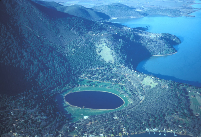
Sixteen young volcanoes designated as Low Threat to Very High Threat are dispersed throughout the area. According to CalVO, partially molten rock, also known as magma, resides beneath at least seven of these: Medicine Lake Volcano, Mount Shasta, Lassen Volcanic Center, Clear Lake Volcanic Field, the Long Valley Volcanic Region, Coso Volcanic Field, and Salton Buttes. Due to the presence of magma, these volcanoes exhibit volcanic earthquakes (seismicity), toxic gas emissions, hot springs, and/or ground movement which is also referred to as deformation.
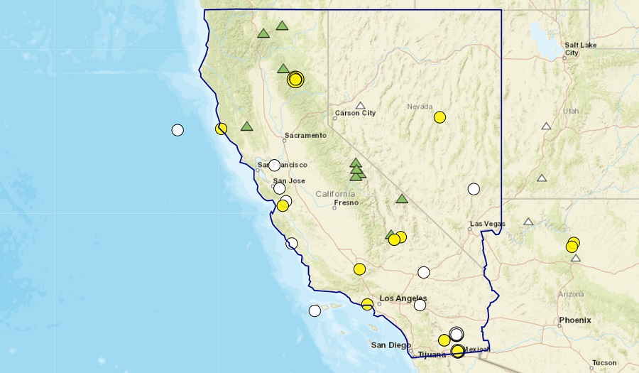
At this time, all volcanoes monitored by CalVO show normal background earthquake activity and ground movement and there is no imminent threat of eruption at any. However, some activity has been detected and measured over the last week.
At the Geysers geothermal field south of Clear Lake Volcanic Field, 99 earthquakes with a magnitude greater than 1.0 were detected, with the largest of the bunch being a magnitude 2.6 event.
In the Sierra Nevada range south of Long Valley Caldera, there were three earthquakes greater than a magnitude 1.0 but the strongest was only a magnitude 1.4 event. According to USGS, these earthquakes occured within a regional fault zone, was related to tectonic movement in the area, and was not associated with the volcano there.
Within the Coso Volcanic Field, CalVO recorded three earthquakes greater than magnitude 1.0, with the largest having a magnitude of 2.0.
Within the Salton Buttes, three earthquakes were also recorded, with the largest having a magnitude of 1.6.
In the U.S., the USGS and volcano observatory units are responsible for issuing Aviation Codes and Volcanic Activity Alert Levels. Aviation Codes are green, yellow, orange, or red. When ground-based instrumentation is insufficient to establish that a volcano is at a typical background level of activity, it is simply “unassigned.” While green means typical activity associated with a non-eruptive state, yellow means a volcano is exhibiting signs of elevated unrest above known background levels. When a volcano exhibits heightened or escalating unrest with the increased potential of eruption, it jumps to orange. Finally, when an eruption is imminent with significant emission of volcanic ash expected in the atmosphere or an eruption is underway with significant emission of volcanic ash into the atmosphere, the code becomes red. Volcanic Activity Alert levels are normal, advisory, watch, or warning. As with aviation codes, if data is insufficient, it is simply labeled as “unassigned.” When the volcano is at typical background activity in a non-eruptive state, it is considered normal. If the volcano exhibits signs of elevated unrest above background level, an advisory is issued. If a volcano exhibits heightened or escalating unrest, a watch is issued while a warning is issued when a hazardous eruption is imminent.