The USGS continues to monitor volcanoes around the United States; of the more than 160 they watch, 8 are experiencing elevated activity that could lead to possible eruption action. Due to that activity, one of them is at an elevated WATCH / ORANGE status while seven are at an ADVISORY / YELLOW level. All of the other volcanoes USGS is monitoring today are either at GREEN or unrated conditions.
All of the volcanoes in the United States are in western states, Alaska, and Hawaii. The Hawaii volcanoes are monitored by the Hawaii Volcano Observatory (HVO) while the Alaska volcanoes are monitored by the Alaska Volcano Observatory (AVO.) In addition to the AVO and HVO, there are also the California Volcano Observatory , Cascades Volcano Observatory, the Yellowstone Volcano Observatory, and the Northern Mariana Islands Volcano Observatory. Each of those additional volcano observatories within the USGS are monitoring volcanoes in their respective regions. At this time, only HVO and AVO are tracking unrest; none of those other observatories are reporting unusual activity or signs of anything more than background noise for now.
The U.S. is only home to a fraction of the world’s volcanoes: according to USGS, there are normally around 2 dozen erupting volcanoes around the world at any given time. The USGS says there are about 1,500 potentially active volcanoes worldwide, with about 500 of the 1,500 erupting in modern historical times.
Within the United States, the USGS tracks dozens of potentially active volcanoes, most of which are in Alaska. In Alaska alone, there are more than 130 volcanoes and volcanic fields which have been active within the geologically young last 2 million years. 50 have been active since the mid 1700s and AVO studies those too.
Another place famous for its volcanoes is Hawaii; on the Big Island of Hawaii, Kilauea, Mauna Loa, and Hualalai are considered active and potential threats. As of today, none are erupting but that could change in the coming days with continued unrest at Kilauea, the most active of the Hawaiian bunch.
In the U.S., the USGS and volcano observatory units are responsible for issuing Aviation Codes and Volcanic Activity Alert Levels. Aviation Codes are green, yellow, orange, or red. When ground-based instrumentation is insufficient to establish that a volcano is at a typical background level of activity, it is simply “unassigned.” While green means typical activity associated with a non-eruptive state, yellow means a volcano is exhibiting signs of elevated unrest above known background levels. When a volcano exhibits heightened or escalating unrest with the increased potential of eruption, it jumps to orange. Finally, when an eruption is imminent with significant emission of volcanic ash expected in the atmosphere or an eruption is underway with significant emission of volcanic ash into the atmosphere, the code becomes red. Volcanic Activity Alert levels are normal, advisory, watch, or warning. As with aviation codes, if data is insufficient, it is simply labeled as “unassigned.” When the volcano is at typical background activity in a non-eruptive state, it is considered normal. If the volcano exhibits signs of elevated unrest above background level, an advisory is issued. If a volcano exhibits heightened or escalating unrest, a watch is issued while a warning is issued when a hazardous eruption is imminent.
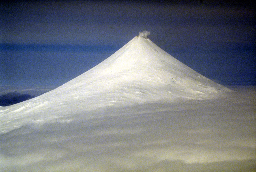
USGS and the AVO unit just upgraded the Shishaldin volcano in Alaska from ADVISORY/NORMAL to YELLOW/GREEN. Strongly elevated surface temperatures at the summit of Shishaldin Volcano have been observed in satellite data over the last 24 hours while intermittent tremor and low-frequency earthquakes over the past week have gradually become more regular and consistent in the past day. AVO cautions, “These observations represent a departure from normal background activity at Shishaldin, but do not necessarily indicate that an eruption will occur.”
Shishaldin Volcano is located on Unimak Island in the Aleutian Islands chain of Alaska; it is the highest mountain peak of the Aleutians, rising to 6,500 feet. It is a large stratovolcano; in 1967, it was designated as a National Natural Landmark by the National Park Service.
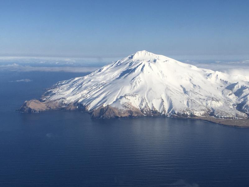
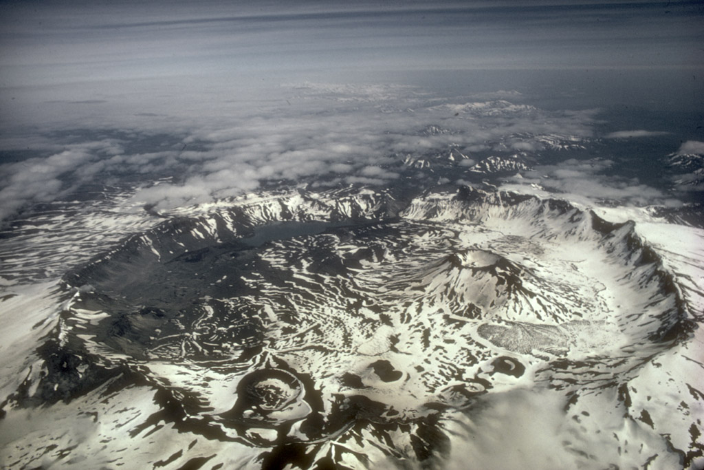
The Great Sitkin Volcano is a basaltic andesite volcano that occupies most of the northern half of Great Sitkin Island, a member of the Andreanof Islands group in the central Aleutian Islands. It’s located roughly 26 miles east of Adak, which is 1,192 miles southwest of Anchorage. According to the AVO, the volcano has a composite structure consisting of an older dissected volcano and a younger parasitic cone with a 1.8 mile diameter summit crater. A steep-sided lava dome, emplaced during an eruption in 1974, occupies the center of the crater. Within the past 280 years, a large explosive eruption here produced pyroclastic flows that partially filled the Glacier Creek valley on the southwest flank.
According to AVO, a slow eruption of lava is continuing at the volcano, producing a thick lava flow within the summit crater. “An eruption of lava began at Great Sitkin Volcano in July 2021 and has continued to slowly erupt since, but no explosive events have occurred,” wrote AVO in today’s daily update. Due to the active eruption, AVO has the Volcano Alert Level here at WATCH while the current Aviation Color Code is ORANGE.
Based on its location on the globe at 179°46′ East, Semisopochnoi is the easternmost land location in the United States and North America, located just 9.7 miles west of the 180th Meridian in Alaska. Semisopochnoi is part of the Aleutian Islands, a chain of 14 large volcanic islands and 55 smaller other islands. These islands, with their 57 volcanoes, make the northernmost part of the Pacific Ring of Fire. Semisopochnoi is monitored by local seismic and infrasound sensors, satellite data, regional infrasound, and lightning detection instruments.
According to the AVO, “Seismicity was low at Semisopochnoi over the past day. No evidence of explosive activity was observed in geophysical or remote sensing data. No activity was observed in partly cloudy satellite and web camera views over the past 24 hours. ” However, USGS adds caution: “Small explosions and associated ash emissions may continue and could be difficult to detect, especially when thick cloud cover obscures the volcano.”
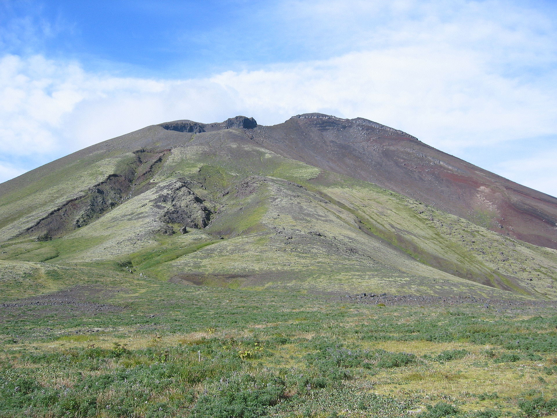
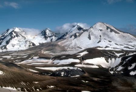
Mount Takawangha is a stratovolcano located in Tanaga Island, Alaska. It sits in close proximity with another volcano known as Mount Tanaga, which shares the same name as the island itself. Older and more eroded volcanoes can also be found east of Takawangha. “Seismicity was low at Tanaga Island over the past day. No activity was observed in cloudy satellite and web camera images,” AVO wrote in their latest update report. For now, Takawangha is at a Yellow aviation color code level and an Advisory volcano alert level.
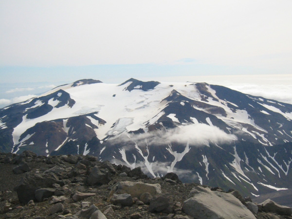
The Trident Volcano is on the Alaska Peninsula inside of the Katmai National Park. There are 23 domes that make up the complex stratovolcano, with the greatest elevation at 6,115 feet. According to USGS, the volcano earned its name from Robert Fiske Griggs of the National Geographic Society; he named it because of the three major peaks he saw there in 1916, similar to the three prongs of a trident fork.
Today, AVO released an update on Trident: “Seismic activity near Trident Volcano remained elevated over the past 24 hours. No activity was observed in partly cloudy satellite and web camera views over the past day. ” The current period of seismic unrest began on August 24, 2022.
Aniakchak Volcano is located within the Aniakchak National Monument and Preserve which is maintained by the National Park Service. In 1967, the volcanic caldera located here was designated as a National Natural Landmark by the National Park Service. The volcano is roughly 3,700 years old and has a caldera that is roughly 6 miles in diameter. The volcano is classified as a stratovolcano.
In their latest volcano update, AVO wrote, ” Seismicity was low at Aniakchak volcano over the past day. No activity was observed in cloudy satellite and web camera views over the past 24 hours… We expect additional shallow seismicity and other signs of unrest, such as gas emissions, elevated surface temperatures, and additional surface deformation to precede any future eruption, if one were to occur.”
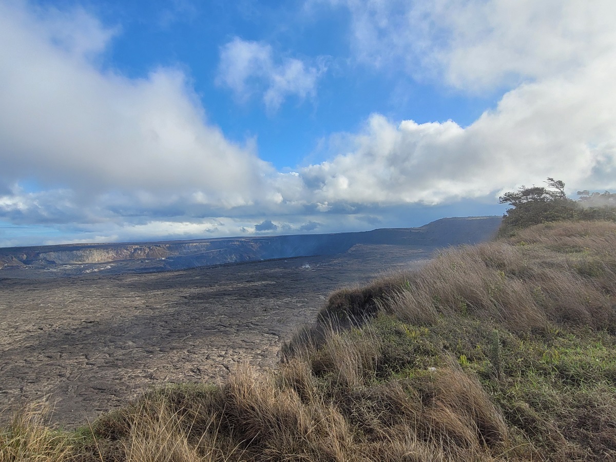
On the Big Island of Hawaii, the Kilauea volcano is not erupting, and no active lava has been observed since the last eruption paused on June 19, 2023. No significant changes have been observed at the summit or in either rift zone over the past week. While seismicity over the past week was at background levels and tilt deformation has been stable, the volcano continues to emit some volcanic gasses, albeit minimal quantities. Sulfur dioxide (SO2) emissions from the summit remain low; the most recent SO2 emission rate, of approximately 170 tonnes per day, was measured on July 6. Measurements from continuous gas monitoring stations downwind of Puʻuʻōʻō in the middle East Rift Zone remain below detection limits for SO2, indicating that SO2 emissions from Puʻuʻōʻō are negligible,” HVO wrote.
HVO/USGS urges visitors of Hawaii Volcano National Park and Kilauea Volcano there to exercise extreme caution at all times. “Other significant hazards also remain around Kīlauea caldera from Halemaʻumaʻu crater wall instability, ground cracking, and rockfalls that can be enhanced by earthquakes within the area closed to the public. This underscores the extremely hazardous nature of the rim surrounding Halemaʻumaʻu crater, an area that has been closed to the public since early 2008. ”
