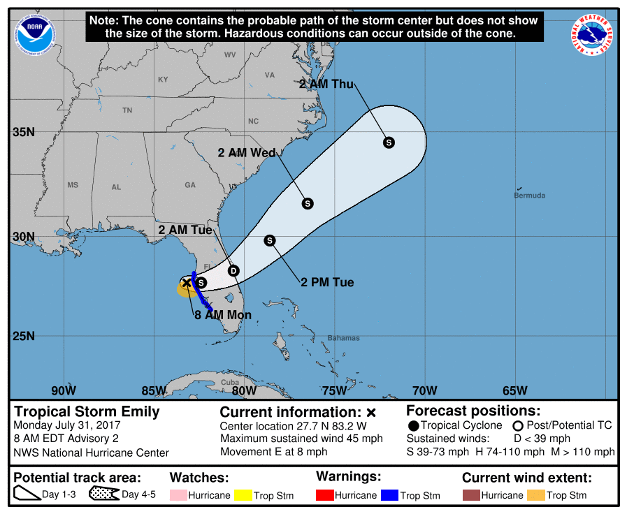
Update: 11:25am 7/31/17: Tropical Storm Emily just made landfall on Anna Maria Island, south of Tampa and north of Sarasota, Florida.
Emily, the fifth named system of the 2017 Atlantic Hurricane Season has formed, prompting authorities to issue Tropical Storm Warnings for the west coast of Florida. At this time, Tropical Storm Warnings have been issued from the Anclote River south to Bonita Beach; this includes Sanibel and Captiva Islands as well as the Tampa/Clearwater area. As of 8am, the center of Tropical Storm Emily was near latitude 27.7 North, longitude 83.2 West and was moving east near 8 mph. According to the National Hurricane Center (NHC), this general motion is expected to continue today with a turn toward the northeast and an increase in forward speed are expected tonight or Tuesday.
On its current forecast track, the center of Emily is expected to move inland over the the west-central Florida peninsula later today and move across central Florida through tonight. Emily is expected to move offshore of the east-central Florida coast early Tuesday.
NOAA Doppler radar data from Tampa, Florida, indicate that maximum sustained winds have increased to near 45 mph with higher gusts. The NHC says little change in strength is forecast until landfall occurs this afternoon. The official NHC forecasts pegs Emily to weaken to a tropical
depression while it moves across the Florida peninsula tonight, but re-intensify back to storm status when it emerges over the Atlantic ocean.
At this time, tropical storm-force winds extend outward up to 60 miles from the center. The estimated minimum central pressure is 1006 mb (29.71 inches).
The two primary hazards associated with this landfalling system are wind and rain.
WIND
Tropical storm conditions are likely within the warning area through this afternoon. Doppler velocity data from the NWS Tampa Bay WSR-88D radar indicate average velocities of 48-50 kt on the south side of the circulation center between 4,500-6,500 ft altitude during the past hour. Using a standard adjustment factor of 80 percent yields an equivalent surface wind of about 40 kt or 46mph. These winds will impact primarily the central west coast of Florida. Waterspouts are also possible along Emily’s path over water leading up to landfall.
RAIN
Locally heavy rainfall across portions of the Florida peninsula during the next few days are possible, with amounts in excess of 4″ expected along the path of the storm.
Experts believe this Atlantic Hurricane Season, which runs through to the end of November, will be a busy one. Dr. Phil Klotzbach and the experts at Colorado State University updated their seasonal outlook again on July 5, showing a much more active than normal season expected. The National Oceanic and Atmospheric Administration (NOAA) also released their own forecast which shows this hurricane season to be likely more active than others.
