It hasn’t officially formed yet, but that hasn’t stopped authorities from issuing watches and warnings for it. Tropical Storm Warnings and Watches are now in effect in the Bahamas and Florida ahead of what the National Hurricane Center expects to become Hurricane Humberto over time. In the latest advisory, the National Hurricane Center says it is still too soon to classify the system as a tropical cyclone because of poor structure, but they add that it is likely the system located near the Bahamas today will become a tropical storm by tonight.
With the threat of at least tropical storm conditions impacting people soon, a Tropical Storm Warning is in effect for the Northwestern Bahamas excluding Andros Island while a Tropical Storm Watch is in effect for portions of the Florida coast from Jupiter Inlet to the Flagler-Volusia County line. A Tropical Storm Warning means that tropical storm conditions are expected somewhere within the warning area within 36 hours. A Tropical Storm Watch means that tropical storm conditions are possible within the watch area, generally within 48 hours. The National Hurricane Center (NHC) cautions the southeastern United States that additional watches and warnings may be required for portions of this area later today.
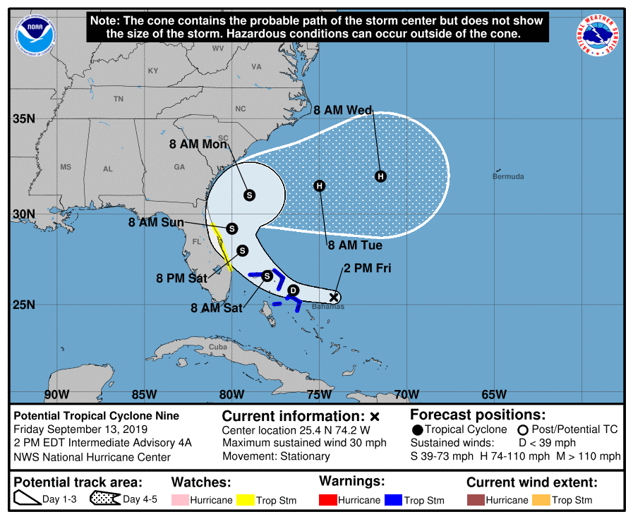
In the latest afternoon update from the National Hurricane Center, the system now known officially as Potential Tropical Cyclone #9 was centered near latitude 25.4 North, longitude 74.2 West. According to the NHC, the system has been meandering during the past few hours, but is expected to resume a slow motion toward the northwest and north-northwest later today. On the forecast track, the system is anticipated to move across the central and northwestern Bahamas tonight, and along or near the east coast of Florida Saturday and Saturday night.
For now, maximum sustained winds are near 30 mph with higher gusts, making it to weak to reach tropical storm status for now. However, preliminary data from an Air Force Reconnaissance plane indicate that the disturbance is becoming better organized, and it is anticipated that a tropical depression or a tropical storm will likely form later today or tonight. The National Hurricane Center believes there’s a 90% chance that this formation will occur over the next 2 days.
For now, the storm is bringing additional misery to people suffering from Hurricane Dorian’s impacts: wind and heavy rain. Tropical storm conditions are expected within the warning area in the northwestern Bahamas later today. Tropical storm conditions are possible in the watch area on the Florida peninsula by Saturday or Saturday night. The potential tropical cyclone is expected to produce 2-4″ of rain in the Bahamas with isolated amounts up to 6″; the U.S. southeast coast from central Florida into central South Carolina can also expect 2-4″ of rain. Fortunately, with winds low and pressures high, this system is not expected to product significant storm surge in the northwestern Bahamas for now.
Where this storm heads next remains a mystery for now. Because it lacks structure, computer forecast models that meteorologists use to aid in their forecasting have been conflicted. Some global guidance runs have forecast significant impacts from a sizeable hurricane on the Mid Atlantic to New England coasts while others suggest a harmless turn out to sea. Others suggest the system won’t be able to form into a tropical cyclone, simply moving into Florida as a weak wet weather event instead. The National Hurricane Center says their confidence is low in their current forecast, which does curve the storm out to see after brushing by Florida’s east coast.
Regardless of the track, it’s important that residents of the entire U.S. East Coast make sure they have a Hurricane Action Plan in place. It may become necessary for people to act on those plans in the coming days.
