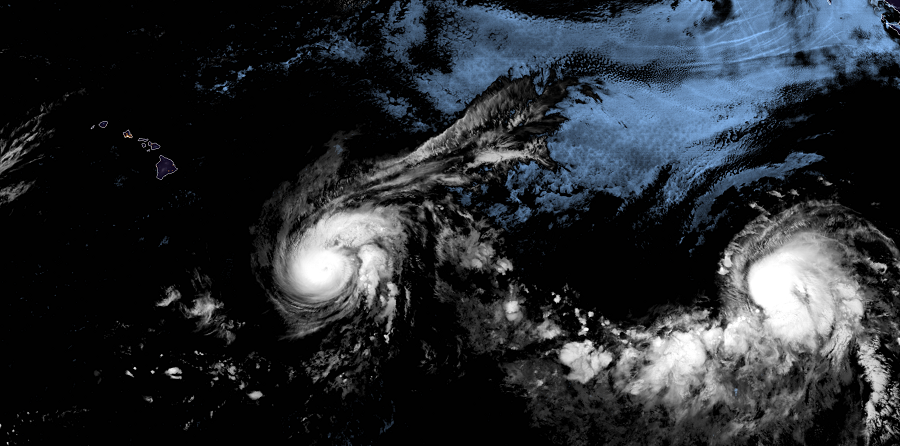
Hurricane Erick reached major Category 4 status on Tuesday but has since weakened to a still formidable Category 3 storm. In the latest advisory from the National Hurricane Center, Erick’s center was located near latitude 14.2 North and longitude 146.3 West and was moving toward the west near 12 mph. According to the Central Pacific Hurricane Center in Honolulu, Hawaii, little change in motion is forecast during the next 48 hours.
While Erick’s direction and speed shouldn’t change much over the next 48 hours, meteorologists believe the hurricane will continue to weaken as it moves towards Hawaii. Right now, maximum sustained winds are near 125 mph with higher gusts. Hurricane-force winds extend outward up to 30 miles from the center and tropical-storm-force winds extend outward up to 125 miles. As the intensity drops, the wind field of tropical storm winds will expand as will the system’s ability to produce heavy rain well away from its center. At this time, Erick is forecast to track well south of Hawaii, but it’ll be wide enough to bring heavy rain and gusty winds to the state.
The first hazard to arrive in Hawaii will be dangerous surf. Swells generated by Erick will arrive in the Hawaiian Islands by early Thursday, if not sooner, potentially producing dangerous surf conditions, mainly along east facing shores. Tropical Storm Watches are in effect for off-shore waters along Hawaii Island’s west and south facing coasts. Hurricane Warnings are in effect further out around the state. At this time, there are no watches or warnings in effect for the islands themselves.
Heavy rain and gusty winds will begin to impact Hawaii island later Thursday and continue into Friday, with rain showers spreading through the rest of the state from east to west on Friday into Saturday. Rain will be heaviest on Hawaii’s Big Island, especially east facing slopes, where several inches of rain will fall. As Erick approaches Hawaii, it should weaken to a tropical storm. The core of sustained tropical storm force winds should remain well off-shore. However, some tropical storm force wind gusts are possible at times, especially on eastern sides of Hawaii Island, the summit areas of Mauna Kea and Mauna Loa, and along Saddle Road between the two summits. Gusty winds are also possible around Haleakala on Maui. Thunderstorms with frequent lightning are also possible in the state as the wide outer bands of the storm rotate their way through the Aloha State.
The storm will exit the region on Saturday, but by Tuesday, another system, Hurricane Flossie, is due to approach Hawaii, perhaps on a direct-hit approach.
NOAA’s Central Pacific Hurricane Center (CPHC) Director, Chris Brenchley, described to us today how his Honolulu team coordinates, collaborates, & even swaps staff with Miami-based National Hurricane Center (NHC) to keep America #HurricaneStrong?@NWSHonolulu pic.twitter.com/W1WM2EeXeC
— the Weatherboy (@theWeatherboy) May 23, 2019
