Defying seasonal norms, it appears yet another winter storm will blast portions of the Mid Atlantic and Northeast with heavy snow yet again this weekend. While snow in April does happen from time to time, it is rare to have back-to-back snow producing storms in March and April.
A robust cold front will plow into the eastern United States today, bringing strong gusty winds, showers, and storms. This cold front will allow the upper air pattern to amplify again towards the end of the week and remain that way into early next week. With a trough pattern returning for the Great Lakes and the Northeast states, temperatures will return to below normal levels for the weekend. A frontal system will approach the region on Friday. Low pressure will again be crossing Ontario and Quebec, Canada and an associated front will cross the area during the afternoon. On Saturday, a wave of low pressure will move along this front’s southern end and move north into the northern Mid Atlantic.
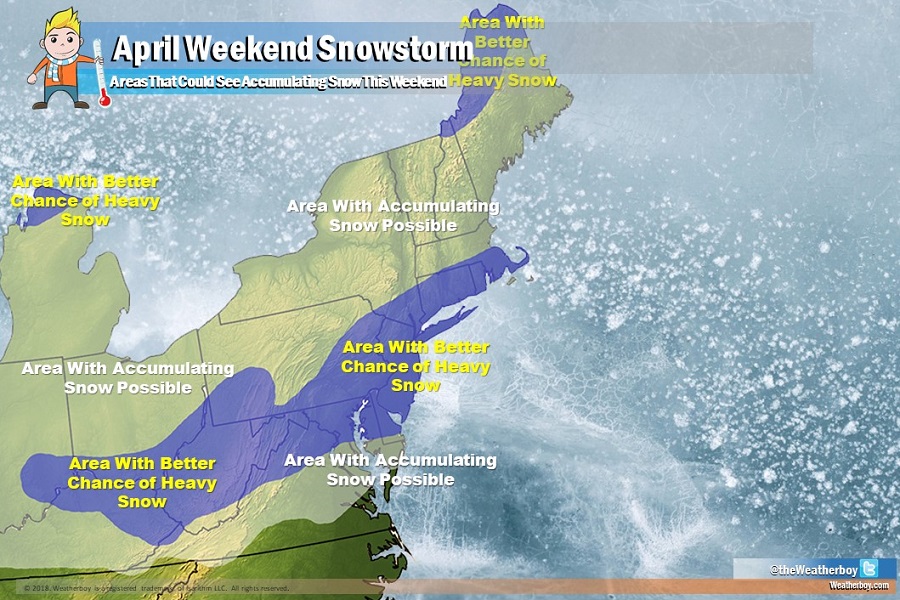
Computer forecast guidance that aids meteorologists with their forecasts agree that a snowstorm will form, but there’s significant differences in the size, intensity, and direction each model suggests the storm will evolve. The overnight run of the European ECMWF model suggests a record-breaking heavy snowstorm late Saturday for the Mid Atlantic, with the heaviest snow stretching from near the Pennsylvania/Maryland border east to the Jersey Shore; it suggests more than a foot of snow could fall in the Washington, DC area with heavy snow possible in Baltimore, MD and Philadelphia, PA too. The American GFS suggests two storms, with the first dropping significant snow across West Virginia, northern Virginia, Maryland, southeastern Pennsylvania, Delaware, New Jersey, the New York City metro area, Rhode Island, and southern Connecticut. It suggests a second storm coming 36 hours later will drop another round of heavy snow over West Virginia and western Maryland, as well as interior New England. As more data is digested by the models in the coming days, it is likely they’ll gel around a similar solution as the storm time nears.
Timing is especially critical with mid-April snow events. Falling snow needs to combat solar radiation which limits snow accumulations even on cloudy days with heavy precipitation. Should the heaviest precipitation fall at night, deep accumulations of heavy, wet snow will occur. If the heaviest precipitation falls during the day, while visibility will be low, snow will struggle to accumulate, especially on roadways.
At this time, it appears widespread accumulating snow is possible and some will see 6 or more inches of accumulation. It is too soon, though, to know where exactly the heavy snow will fall, but odds for the heaviest snow are greatest over West Virginia, Maryland, and the Washington, DC to New York City, NY I-95 corridor area.
