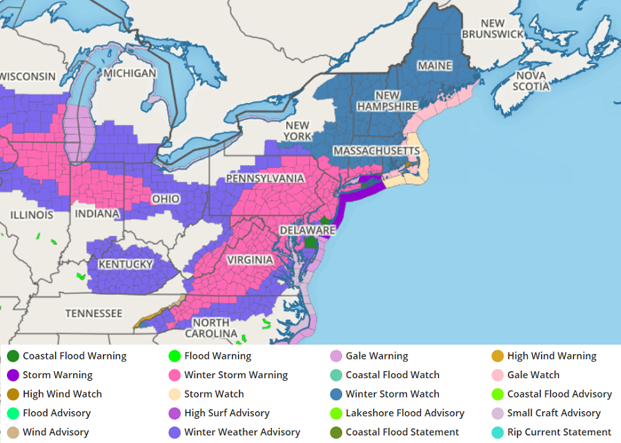
A significant winter storm will begin to unfold later today across portions of the Mid Atlantic, with heavy snow, gusty winds, and coastal flood threats spreading up to New England in the coming days. Before all is said and done, more than a foot of snow is expected to fall across a broad area, making it the most significant storm of the 2020-2021 winter in the east. Due to severe winter weather conditions expected, the National Weather Service has expanded Winter Storm Warnings into the New York City area and southern Connecticut and has expanded Winter Storm Watches north throughout eastern Upstate New York and all of New England.
Accumulating snow falling now in Virginia will expand north and east into Maryland and Delaware by lunch, into southeastern Pennsylvania and southern New Jersey by dinner, and into the rest of Pennsylvania and New Jersey and the New York City metro area by 8-10 pm.
As the snow expands into New York City, snow will begin to mix with and change to rain across eastern Virginia and Maryland, the southern 2/3rds of Delaware, and Cape May County, New Jersey. Places a bit further inland around the Washington, DC and Baltimore, MD metro areas will mix with or change to sleet and freezing rain at about the same time. Sleet and freezing drizzle will extend north into southeastern Pennsylvania by 3am Monday while rain will push north towards central New Jersey. By 11am, the rain should stop its northward advance in New Jersey just south of I-195. North of there, in the New York City area and the northern half of New Jersey, snow will become heavier.
On Monday morning, snow will push into southern New England. By 11am, the snow should approach the Massachusetts/Vermont-New Hampshire state lines. Snow should also break out across southeastern New England, including Cape Cod and the nearby islands. By 2pm Monday, snow should change over to rain over extreme eastern Long Island and extreme southeastern New England. By 5pm, rain will push into southeastern New England just south of Boston as snow advances north into upstate New York and central and northern New England.

As the rain advances in New England, wrap-around cold air should turn rain back to snow over New Jersey, Delaware, and eastern Maryland. By 6pm Monday, any rain falling anywhere in New Jersey and Delaware should change back to snow. Snow showers will continue across portions of the DelMarVa Peninsula , New Jersey, and Pennsylvania throughout Tuesday morning as heavier snow takes hold over northern New England. Snow showers should continue throughout the northeast during the day and evening on Tuesday as rain showers persist over southeastern New England.
By midnight Wednesday morning, rain should change back to light snow over southeastern New England while snow showers continue over the rest of New England. Scattered snow showers will linger around New Jersey and the New York City metro area until about 6am on Wednesday. By 3pm Wednesday, snowfall in the northeast should be confined to northern New York, Vermont, New Hampshire, and much of Maine.
By midnight Wednesday night / Thursday morning, the snow should be wrapped up across the northeast as high pressure builds in. While high pressure is building in, a stray flurry or two is possible over northern and central Vermont and New Hampshire, with the greatest threat for flurries over the highest terrain.
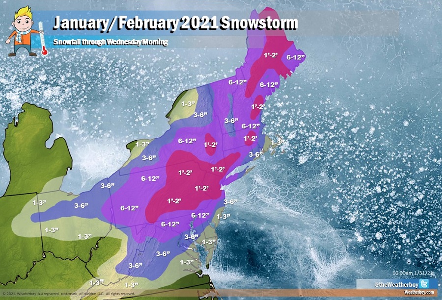
When the storm is completely wrapped up, the highest snowfall amounts should come in at about 22-24″. Boston, Baltimore, and Washington, DC should get 6-8″ while Philadelphia will see 6-12″. New York City should get about a foot, with more west in New Jersey. New Jersey and Massachusetts will see significant differences in snow totals over short distances due to the prolonged presence of rain south of the rain/snow line. While Boston should see 6-8″, Hyannis should only see an inch or two while Worcester could see a foot or more. While Freehold should get more than a foot of snow, Toms River should only get 2-5″. While Philadelphia and Wilmington will see 6-12″, Atlantic City and Georgetown will likely only see an inch or two total. Note that areas that get accumulating snow before the change-over to rain will see some, if not all, of the earlier snowfall wash away.
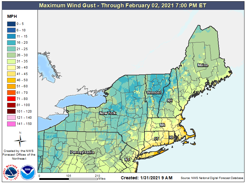
In addition to heavy snow, there will be other storm hazards to contend with. Gusty winds will help to blow and drift snow, which will make visibility low and travel difficult if not impossible at times. While widespread damaging winds aren’t expected, some isolated areas could see power outages due to localized gusts.
The National Weather Service also has Coastal Flood Warnings for portions of the coast. In New Jersey, a Coastal Flood Warning is in effect from 7am tomorrow through to 5pm Tuesday for the possibility of 1-2′ of coastal inundation above ground level in low-lying shoreline areas of Middlesex, Monmouth, Ocean, and Burlington counties. Minor to moderate flooding is possible here and elsewhere up and down the coast from Delaware beaches to southern Maine. The National Weather Service doesn’t expect coastal flooding to reach “major” levels at this time.
