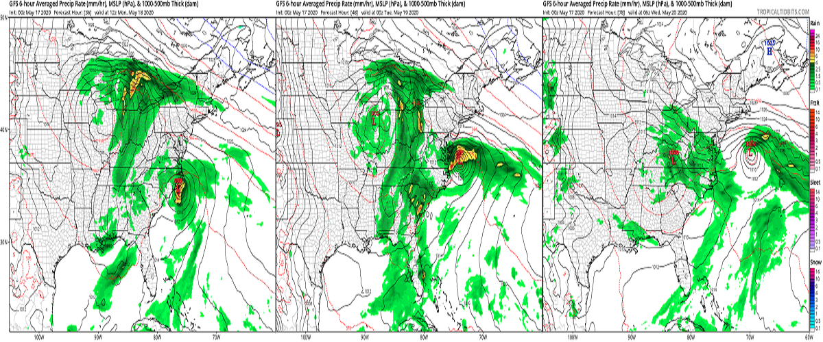
The National Hurricane Center (NHC) in Miami, Florida has upgraded Tropical Storm Watches to Tropical Storm Warnings this morning for the North Carolina coast. While the odds of tropical storm conditions arriving in the Mid Atlantic are increasing, odds are also increasing that an area of low pressure moving through the eastern half of the country will help boot Tropical Storm Arthur out to sea before it can do too much harm.
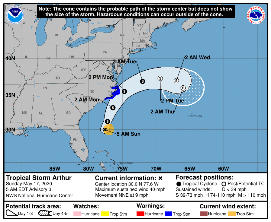
As of the 5:00am update from the NHC, the center of Tropical Storm Arthur was located near latitude 30.0 North, longitude 77.6 West. Arthur is moving toward the north-northeast near 9 mph. Based on the current forecast track released by the NHC, a turn toward the northeast with an increase in forward speed is expected during the next 24 to 48 hours. On the forecast track, Arthur will remain well offshore the east coast of Florida, Georgia, and South Carolina today, and then move near or just east of the coast of North Carolina on Monday.

For now, maximum sustained winds are near 40 mph with higher gusts. According to the NHC, some strengthening is forecast during the next 48 hours. However, beyond that, the NHC expects Arthur to lose its tropical characteristics on Tuesday. The current estimated minimum central pressure is 1006 mb or 29.71 inches.
An approaching low pressure system that’ll move into the Ohio Valley will likely steer Arthur away from the Mid Atlantic coast, protecting places like Delaware, New Jersey, and New York with the worst impacts from this storm. Yesterday, computer forecast models were split in how the two systems would interact; some suggested the Ohio Valley low would help draw the system into the coast while others suggested the storm would head out to sea. The NHC embraced the out-to-sea track in their first forecast, where it also remains with their latest track update.
While the worst of the storm will remain off-shore, gusty winds and heavy rains are still likely for some, especially coastal North Carolina where Tropical Storm Warnings are in effect. The Tropical Storm Warning is up for Surf City to Duck, North Carolina; it includes the Pamlico and Albermarle Sounds. A Tropical Storm Warning means that tropical storm conditions are expected somewhere within the warning area within 36 hours.
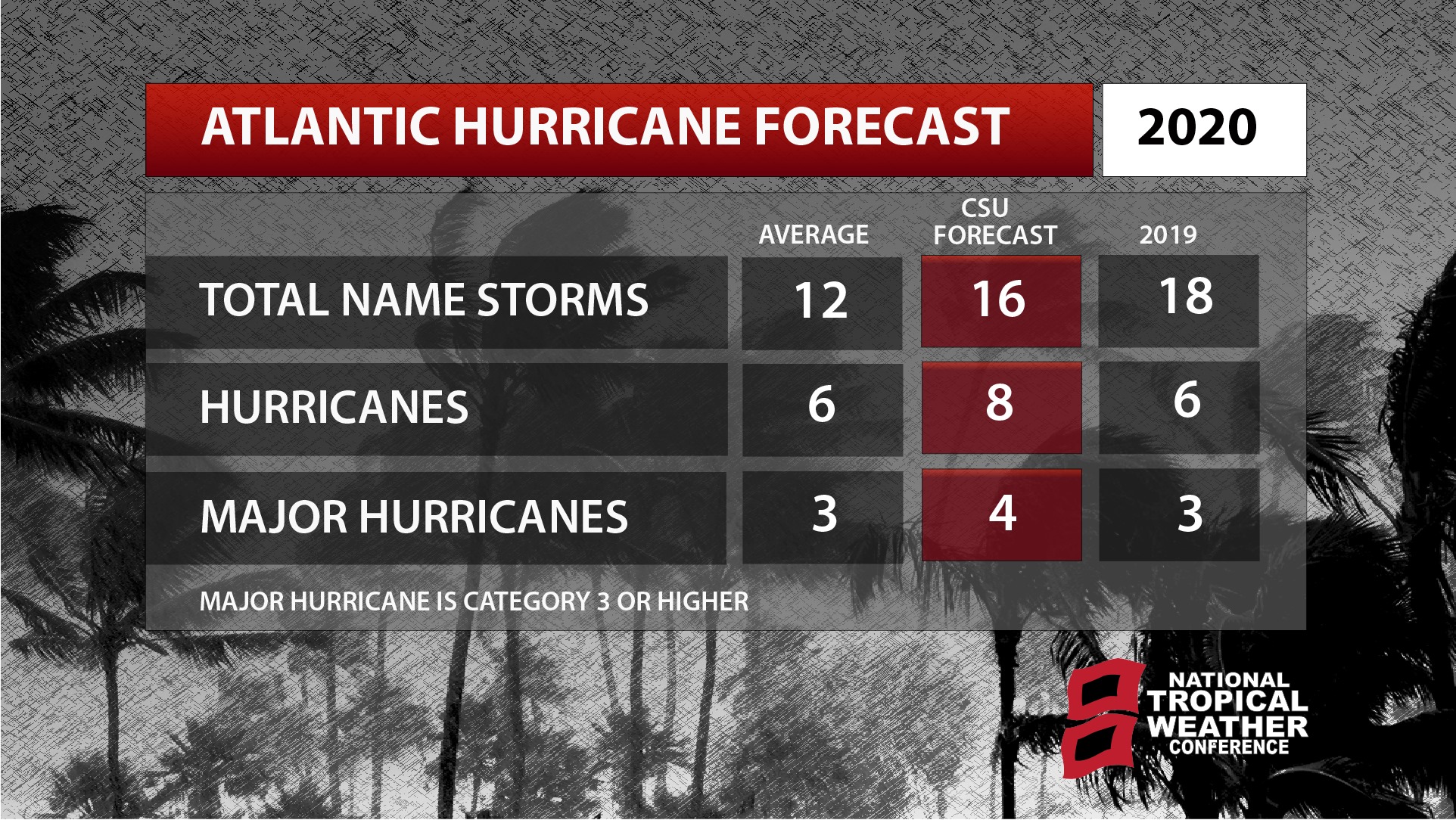
Experts with the Tropical Meteorology Project at CSU believe the upcoming hurricane season will be a particularly busy one with increased chances of a landfalling tropical system compared to typical seasons. NOAA is scheduled to unveil their official outlook for the season next week for both the Atlantic and Central Pacific hurricane basins and seasons.
