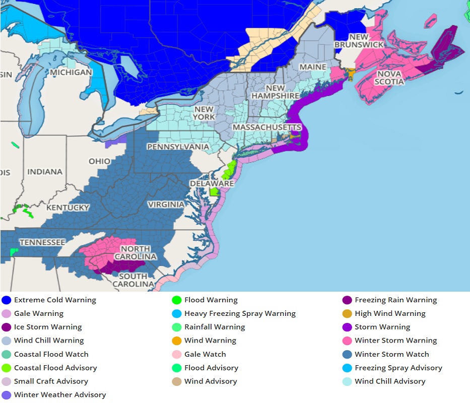
The National Weather Service continues to issue watches, warnings, and advisories ahead of a major winter storm forecast to bring a variety of wintry conditions from the southeast to the northeast; Winter Storm and Ice Storm Warnings are among the many now in effect.
The stage is set for a low pressure system to consolidate and intensify as it moves across the Deep South into the Southeast during the weekend. Arctic air settling into the Plains and the Ohio Valley will interact with the low pressure system to push an area of moderate to locally heavy snow
down the mid-section of the country through tonight. As the arctic air oozes to the south, rain that initially falls in areas farther south is forecast to change over to a period of freezing rain and/or sleet before changing over to snow. This change over from rain to snow is expected to impact areas as far south as Arkansas and Tennessee Saturday to Saturday night. The rain will then expand across the Deep South as the low pressure system begins to intensify and track eastward across the region.
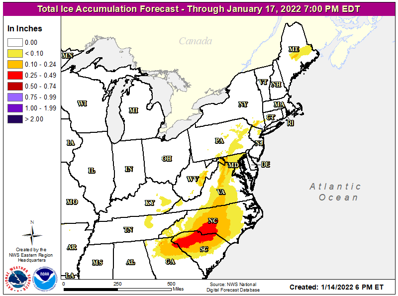
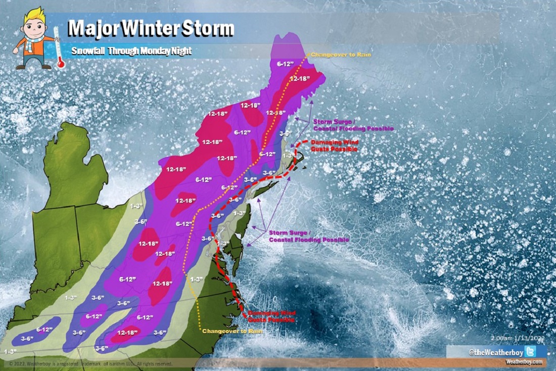
Farther east over the Piedmont section of Georgia and the Carolinas, it appears that a significant icing event is in store beginning Saturday night before spreading up the I-95 corridor during the day on Sunday as the low pressure system tracks up the East Coast. Meanwhile, arctic air farther inland will support widespread snow and areas of mixed precipitation from the Tennessee Valley and upper Ohio Valley to much of the Appalachians on Sunday. The combination of snow and ice will likely cause hazardous driving conditions on roads. Closer to the coast, rain could become heavy on Sunday along with gusty winds and a chance of thunderstorms as the low center is forecast to track through the Southeast.
Due to the hazards created by this storm, Winter Storm Watches are being issued for most of Tennessee, eastern Kentucky, northern Georgia, central North and South Carolina, western Virginia, eastern Ohio, all of West Virginia, much of Pennsylvania, and portions of Maryland, New Jersey, and New York. Winter Storm Warnings and Ice Storm Warnings are now in effect for portions of western North Carolina and the northern third of South Carolina, where freezing rain accumulations may be significant.
As winds pick up, especially along the coasts of the Mid Atlantic and New England, coastal flooding threats will increase. For now, the National Weather Service has issued a Coastal Flood Advisory for the Jersey shore and southern Delaware beaches. Significant storm surge flooding and coastal flooding at times of high tide are possible as this storm intensifies Sunday into Monday.
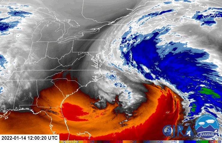
While this new winter storm takes shape, the northeast will need to deal with one that is exiting east coast waters and impacting Canada. A rapidly deepening area of low pressure system well off the East Coast will drag arctic air from eastern Canada into the Northeast, bringing frigid conditions, strong gusty winds and dangerous wind chill temperatures through tonight and into Saturday. Because of that, Wind Chill Warnings and Wind Chill Advisories are up throughout the northeast tonight into tomorrow morning.
