A winter storm is forecast to bring upwards of 6-12″ of snow to portions of the northeast in the final days of February, making a region that has seen little snow this season get covered in a substantial layer of snow. While the I-95 corridor from Philadelphia north will likely see some snow, milder air mixing into the storm will change any frozen precipitation to liquid in southern portions of the storm while snow continues over central, interior New England.
A strong low pressure system is forecast to track into the Great Lakes later Monday and weaken while another low pressure system is forecast to develop off of the northern Mid-Atlantic coast. This system will bring widespread precipitation to the the northeast on Monday night before lifting away to the north and east on Tuesday. Weak high pressure will make a brief return on Wednesday before another storm brings another round of precipitation to the northeast later Wednesday evening into Thursday and Friday.
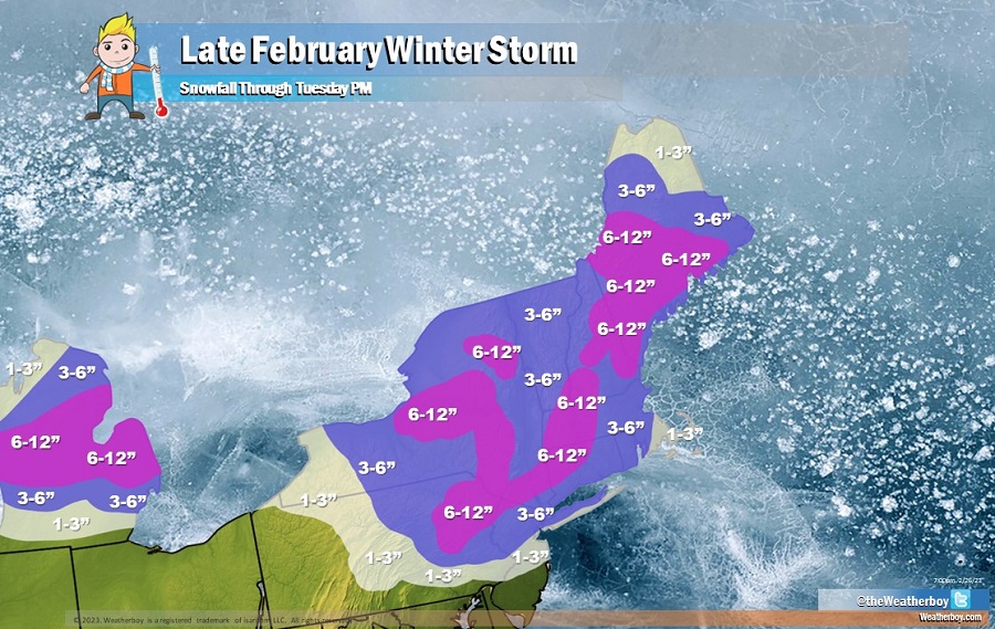
Before the storm wraps up on Tuesday, several inches of snow will fall. 1-3″ of snow is possible across central New Jersey, the South Shore of Long Island, and southeastern New England; however, milder air being drawn up into this system will likely change snow over to rain, washing away snow that falls earlier. Philadelphia could see a brief coating of snow before rain arrives; New York and Boston could see a few inches of snow before a wintry mix of rain/snow or plain rain arrives. North of the major I-95 cities, the colder air will win out over the milder air. Across northeastern Pennsylvania, northern New Jersey, Upstate New York, and interior New England, 3-6″ of snow is expected to fall. There will also be areas of 6-12″ snow amounts, primarily over the highest terrain of New York, Pennsylvania, Connecticut, New Hampshire, Vermont, Massachusetts, and southern Maine.
Areas that see significant snow from this storm will likely see more accumulating snow from the system moving through later in the week. However, along the I-95 corridor and coastal areas south of Boston, mainly rain is expected from that new system.
