A winter storm is forecast to bring snow, wind, and rain to the northeast in time for Thanksgiving Day and Black Friday. A dynamic mid-latitude cyclone will track through the Mississippi Valley, Tennessee Valley, Upper Ohio Valley, and near the New England coast
through Thanksgiving day. Scattered showers and thunderstorms will spread into the East Coast tonight and progressively shift eastward. While rain will fall across the I-95 corridor including in and around the big cities of the Northeast, a swath of moderate to heavy snowfall is likely to develop across portions of the interior Northeast.
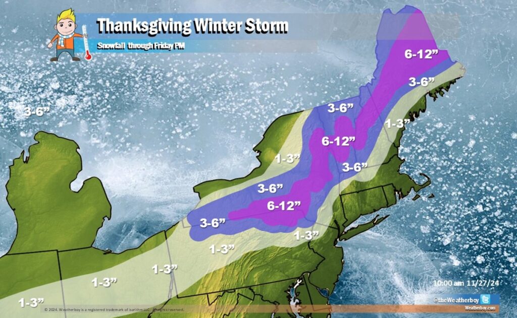
Due to the threat of heavy snow, the National Weather Service has issued Winter Storm Watches for counties likely to see heavy snow.
This winter storm will also help allow for a reinforcing blast of colder air to spread over much of the eastern United States. A disturbance aloft will allow for the development of a new cold front late on Thanksgiving which moves east and south ahead of a strong and cold surface high. In the wake of this front, as temperatures cool further, lake effect snows should expand and intensify as they interact with record warm Great Lakes water temperatures for so late November. Florida will remain mild to warm.
While early forecast guidance suggested the possibility of a snowstorm for the I-95 corridor, guidance now continues to remain in solid agreement showing a low track over the I-95 corridor which is an unfavorable track for any widespread snowfall along and to the south and east of the highway. For now, it looks like 6-12″ of snow will fall in northern Pennsylvania, southern and eastern Upstate New York, portions of Vermont and New Hampshire, and central and northern Maine. More snow will fall as the lake effect process kicks-off later as this storm departs with additional heavy snow expected there beyond Friday PM.
As the system moves away, cold high pressure will build into the eastern United States with record low temperatures possible in the southeastern U.S.
