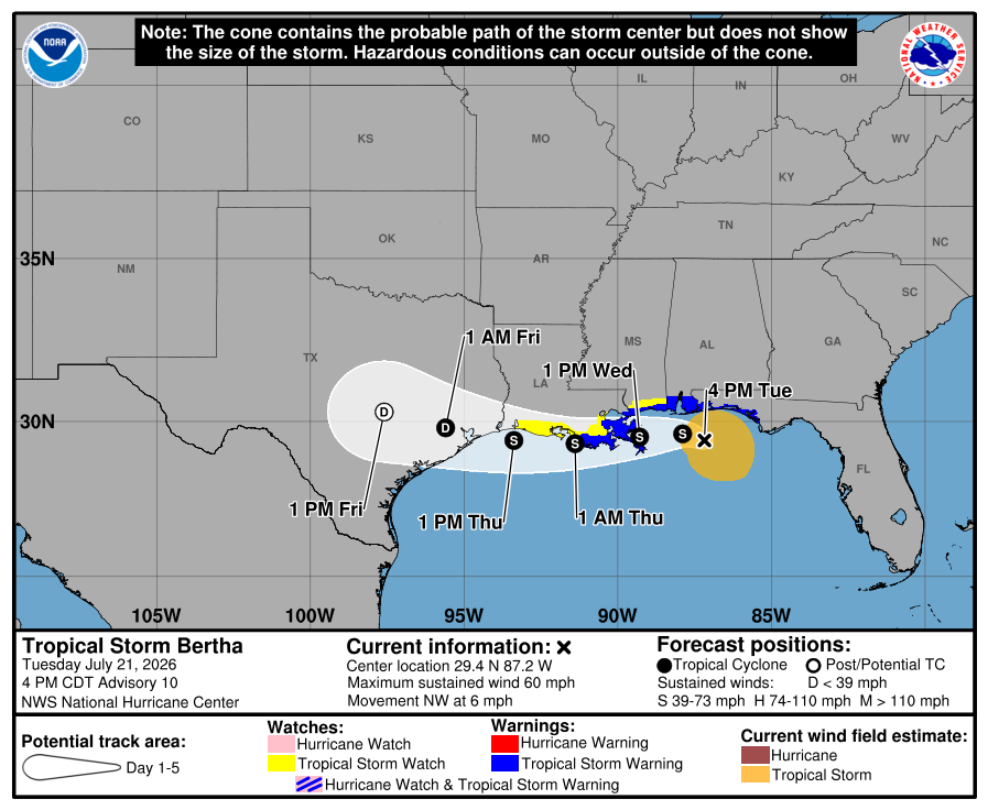
Tropical Storm Bertha continues to head in a westward direction, prompting the National Hurricane Center to expand their advisories west along the central Gulf of America Coast. As of the last advisory from the National Hurricane Center (NHC), Bertha was located about 105 miles west-southwest of Panama City, Florida and about 105 miles south-southeast of Panama City, Florida.
Bertha’s maximum sustained winds are up to 60 mph while its minimum central pressure is down to 995 mb or 29.39″. The storm is moving to the northwest slowly at 6 mph.
Today, the NHC expanded the Tropical Storm Warning westward to Morgan City, Louisiana. The Tropical Storm Watch has also been upgraded to a Tropical Storm Warning for Metropolitan New Orleans and Lake Pontchartrain. The Tropical Storm Watch has also been extended westward to Cameron, Louisiana. As such, the Tropical Storm Warning is now in effect from the Bay/Gulf County line in Florida to Morgan City, Louisiana and the metropolitan New Orleans and Lake Pontchartrain areas. The Tropical Storm Watch is up from west of Morgan City, Louisiana to Cameron, Louisiana and for Lake Maurepas. A Tropical Storm Warning means that tropical storm conditions are expected somewhere within the warning area within 36 hours. A Tropical Storm Watch means that tropical storm conditions are possible within the watch area, in this case in the next 24 to 48 hours.
The NHC expects Bertha will make a turn toward the west-northwest and west tonight, with a continued westward motion forecast Wednesday through Friday. On the forecast track, Bertha will move near or along the northern Gulf Coast during the next couple of days or so. Little change in strength is expected tonight, and gradual weakening is forecast Wednesday through Friday.
Tropical storm conditions will continue spreading across portions of the northern Gulf Coast within the warning area tonight through Wednesday. Tropical storm conditions are possible within the watch area in Louisiana by Wednesday night.
The combination of storm surge and the tide will cause normally dry areas near the immediate coast to be flooded by rising waters moving inland from the shoreline. The water could reach up to 2-4 feet from the Mouth of the Mississippi River to the Mississippi/Alabama border if the peak surge occurs at the time of high tide. A 1-3 foot storm surge is also possible from Cameron, Louisiana to the mouth of the Mississippi River, from the Mississippi / Alabama border to the Aucilla River in Florida, and across Lake Pontchartrain. The deepest water will occur along the immediate coast. Surge-related flooding depends on the relative timing of the surge and the tidal cycle, and can vary greatly over short distances.
Bertha is expected to produce total rainfall amounts of 2-4″ with isolated higher totals around 6″ through Thursday along the central Gulf Coast from western Florida into southern Louisiana. This rainfall may produce isolated flash
flooding, especially in urban areas. However, it appears most of the rain and wind associated with this storm will remain over the open waters of the Gulf of America moreso than inland locations along the Gulf of America coast.
