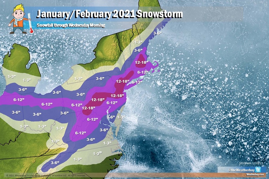
The National Weather Service is in the process of expanding an area covered by Winter Storm Warnings in the east, indicative of increasing confidence of a major storm that is likely to drop a lot of snow in a region that hasn’t seen much yet this season. Up to a foot or more of snow is expected to fall around the Mid Atlantic, with the heaviest amounts over central Pennsylvania, central and northeastern New Jersey, southeastern upstate New York, and just inland in southeastern New England.
Winter Storm Warnings are issued when heavy snow and/or significant accumulations of ice are expected. When it comes to snow, in the southern Mid Atlantic, 5″ or more necessitates a Winter Storm Warning while 6″ or more necessitates a Winter Storm Warning in the northern Mid Atlantic and places north.
This will be a multi-day event stretching from the last day of January into the first few days of February, with snow arriving in the southern Mid Atlantic late Sunday and exiting New England by early Wednesday. Most areas should see a 48 hour window of some falling precipitation.
The system responsible for the snow originated in the Pacific days ago. Starting as an atmospheric river event, the storm dumped rain measured in feet and snow measured in yards across portions of California and Nevada. Left-over energy associated with that disturbance will reorganize and re-intensify off of the Mid Atlantic coast, creating a new winter storm in the east.
Some areas will see more than just snow. While precipitation will start as snow across Washington, DC, Baltimore, all of Maryland and Delaware, and southern New Jersey Sunday evening, it will likely change to plain rain by early Monday morning. Snow could mix with sleet and rain and change to plain rain as far north as I-195 across central New Jersey by Monday afternoon. However, as the storm intensifies and moves off-shore, the precipitation should change back to snow by Monday night in those areas. By Tuesday morning, snow should fall throughout eastern Maryland, Delaware, and New Jersey. But on Tuesday morning, the snow falling in southern New England should change to rain, where it will change back to snow by Tuesday night. Most precipitation will end early Wednesday, with the exception being a few lingering snow showers across portions of New England which won’t completely clear out until Wednesday night.
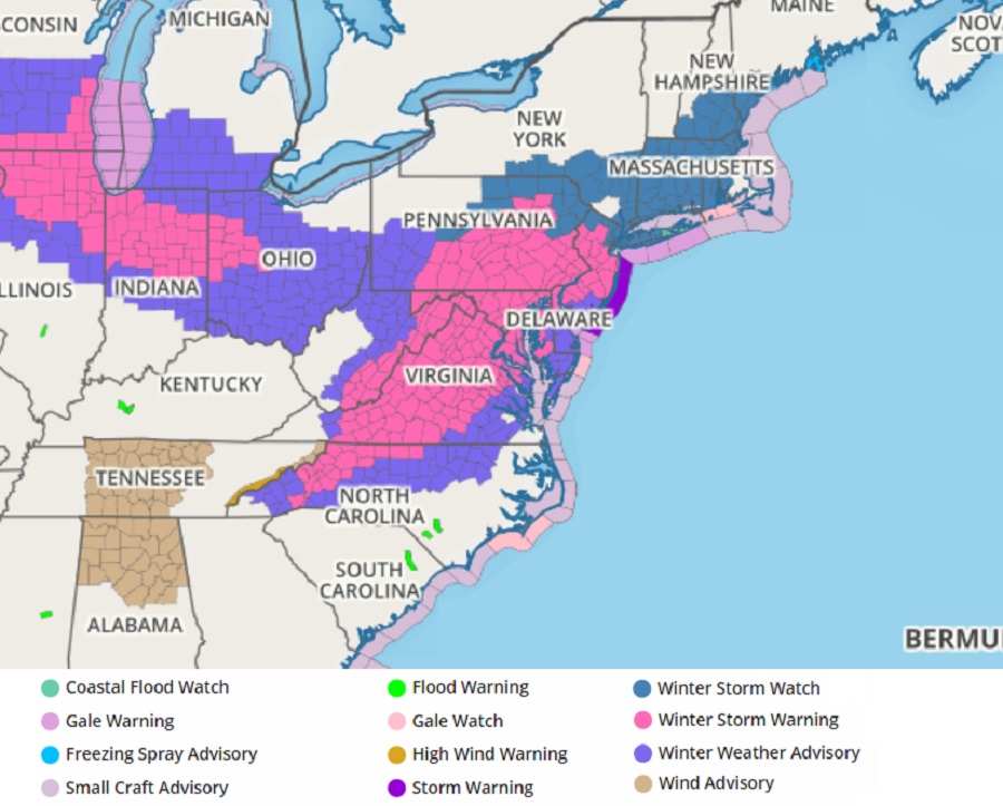
Where rain is expected to keep snow totals lower in southern New Jersey, Delaware, and eastern Maryland, the National Weather Service has issued Winter Weather Advisories.
Just north and west of the rain/snow line, though, very heavy snow will fall. Up to 18″ is possible for central New Jersey towns north of I-195; the same is true for Philadelphia’s northern and western suburbs.
There’s a risk of thundersnow, especially on Monday night across southeastern Pennsylvania, and central and interior southern New Jersey. The National Weather Service cautions: when thunder roars, head indoors; lightning can kill in any season. If thunder is close enough to be heard, lightning is likely close enough to kill.
Along the coast, coastal flooding, beach erosion, and rough surf are all possible as the coastal storm intensifies as it slides north and east. Because of these threats, advisories have been posted for portions of the coastline and adjacent maritime areas.
