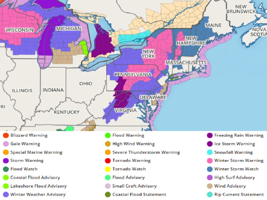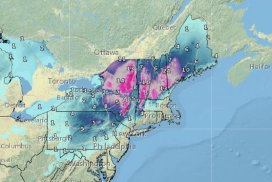
The National Weather Service has expanded the area covered by Winter Storm Warnings, Winter Weather Advisories, and other related watches and warnings for a winter storm moving through the Northeast tomorrow into Friday. A significant coastal storm is forecast for the northeast, with heavy rain, heavy snow, accumulating freezing rain, strong winds, and even the potential for coastal flooding along portions of the Northeast and Mid Atlantic coast.
The National Weather Service has been busy not only issuing advisories, but upgrading ones that were previously in effect. As examples, the Winter Storm Watch was upgraded to a Winter Storm Warning for Monroe County and to a Winter Weather Advisory for Carbon County in Pennsylvania. The previously issued Winter Weather Advisory was expanded to include Kent and Queen Anne’s Counties in Maryland where forecaster confidence has increased that a light glaze of ice may impact the morning commute. Winter Weather Advisories remain in effect for other eastern and southeastern Pennsylvania counties as well as the New Jersey counties adjacent to the Philadelphia Metro area.
A cold and dry surface high over Quebec ridging southward into the mid Atlantic region tonight will give away to a a large surface low impacting the north central United States and Mississippi River Valley today. Low clouds will increase overnight as the large storm system inches closer to the northeast. The cold, dry airmass in place will be an important factor as the large low pressure system moves into the region, beginning early Thursday morning, setting the stage for slick and icy conditions at the start on the southern edge of this winter storm.
The low pressure will consolidate along the coast on Thursday while deepening and moving north and east. The strong high banked to the north supplying the cold air for this system will help snow accumulate quickly, especially over interior New England where more than a foot of snow is possible. Two feet of snow are even possible at the highest elevations of New Hampshire from this storm.

The strong high will also force a very strong pressure gradient causing strong east to north-east winds by Thursday night into early Friday. These high winds will also help drive seawater on-shore creating coastal flooding problems for some communities where the wind is driving the water to land at just the right trajectory.
The onset of precipitation will begin early Thursday morning across the DelMarVa region, southeast Pennsylvania, and extreme southern New Jersey. Around daybreak, the precipitation will start light with primarily snow northwest of the I-95 corridor with a light mix of rain, snow, sleet, and freezing rain near and southeast of the I-95 corridor, including southern Delaware and the Eastern Shores of Maryland. Through the morning, precipitation will spread gradually north and east across the region while increasing in intensity. This is when the morning commute along the I-95 corridor and points north looks to become wintry, with frozen precipitation totals of a light glaze of ice and perhaps a dusting of snow and sleet.
Easterly winds increasing throughout the day on Thursday will begin to usher in warmer maritime air across the northern Mid Atlantic, transitioning any snow to become a wintry mix of snow/sleet/freezing rain, and eventually to all rain. For now, the National Weather Service expects this transition to a wintry mix across much of the I-95 corridor to begin just after daybreak Thursday, impacting the morning rush hour and resulting in hazardous travel.
“This wintry mix may only last a couple hours or even less before turning into all rain along the I-95 corridor and points south and east, but the impacts will be ill-timed with the morning commute,” cautions the Mount Holly, New Jersey office of the National Weather Service in their latest forecast discussion.
The easterly winds will bring in mild enough air above freezing to locales near and north of Trenton before precipitation begins, so much of central and north central New Jersey near and north of I-195 should experience mostly rain and no wintry travel impacts are expected.
The wintry precipitation will last longer farther north where it may persist through most of the day for places like the Lehigh Valley and points northward into the southern Poconos and Northwest New Jersey. However, even in much of this region the initial snow should start to mix with sleet and freezing rain into the afternoon as warmer air moves in aloft. By Thursday evening and overnight, any frozen or freezing precipitation is expected to change to rain for most of the region with the southern Poconos hanging on the longest to a wintry mix through perhaps as late as the predawn hours Friday.
The coastal low will track slowly north across the coastal plain through the night reaching southern New Jersey by Friday morning. This will mean a very stormy night and it is during this time areas south of New York City should see the heaviest
precipitation and strongest winds. Rain, heavy at times, could even be enough to result in some localized flooding issues. There is even the risk of thunderstorms from southern New Jersey to central Virginia from this developing story.
Winds will be powerful during the storm. East winds of 20 to 30 gusting to 40 to 50 mph along the coast and winds of 15 to 25 gusting 25 to 40 mph inland are expected. These winds could lead to some power outages for coastal areas; it’s also possible in the southern Poconos and far northwest New Jersey due to the combination of the winds plus the load of snow and/or ice on wires. Due to high winds expected, the National Weather Service has issued a Wind Advisory for portions of the Atlantic coast of Delaware and New Jersey.
On Friday, the low will track slowly from southern New Jersey towards southern New England. Precipitation should slowly begin winding down southwest to northeast as the day progresses. Strong east to northeast winds will persist into the
morning but then shift around to the northwest in the afternoon and start to diminish in intensity on the backside of the low.
The whole system should clear the northeast completely by late Friday night, allowing portions of the northeast to dig-out from a hefty early season snowstorm.