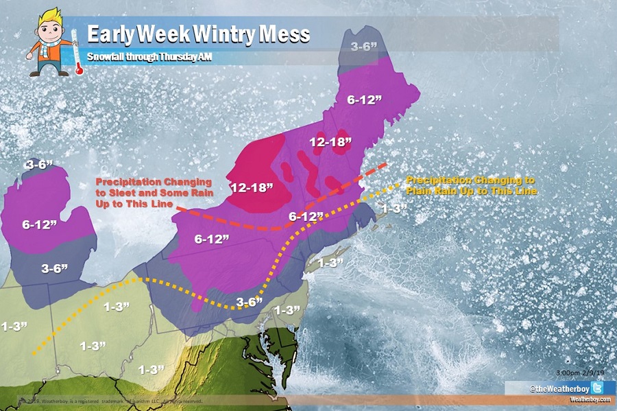
A wintry mess will be heading east in the coming days, bringing a mixed bag of precipitation to the Great Lakes, Mid Atlantic, and Northeast. Snow will fall in the I-95 corridor cities between Baltimore and Boston, but much of that will change to plain rain , especially south of Connecticut, which will wash away much of what snow falls and/or leave behind a slushy mess. Even portions of central New England will change to sleet and some plain rain, which will keep at least the top layers of what snow does fall as a slushy, heavy, wet mess.
High pressure will build into the Northeast tonight before moving offshore Sunday. A weak system will move through the Mid Atlantic Sunday night and Monday. Then the primary storm arrives as a strong surface low is forecast move from the central plains Monday night to the Great Lakes region Tuesday night, with a secondary low developing in vicinity of the Mid-Atlantic on Tuesday. Precipitation will continue in New England on Wednesday before high pressure arrives in the eastern U.S. by Thursday morning, drying the region out.
Monday’s disturbance should put down a light blanket of snow across portions of West Virginia, northern Maryland, northern Delaware, southern Pennsylvania, and southern New Jersey. More precipitation will push into this area early on Tuesday, adding to frozen precipitation totals. But during Tuesday morning and afternoon, milder air will surge north, changing snow to plain rain across much of Ohio, Pennsylvania, New Jersey, southeast New York, Connecticut, and Rhode Island. While a few inches of snow could accumulate prior to this change over, much of it will wash away or turn to a messy slush as the change over occurs. A change-over is expected as far north as upstate New York and northern Massachusetts; because it’ll happen later after more snow falls, it will only knock down snowfall amounts slightly, especially over upstate New York. North of central upstate New York and in the higher elevations of Vermont and New Hampshire, it’s possible more than a foot of snow will fall with no change-over to plain rain expected there. Most precipitation will end Tuesday night into Wednesday morning; however, snow shower activity will linger across northern New England Wednesday afternoon into Wednesday night. By Thursday morning, all precipitation should be done, even in northern Maine.
High pressure will return on Thursday, allowing people to dig or dry out. But it appears another system will bring another round of rain to the northeast Friday and Saturday, even in areas that pick up snow from this early-week system.