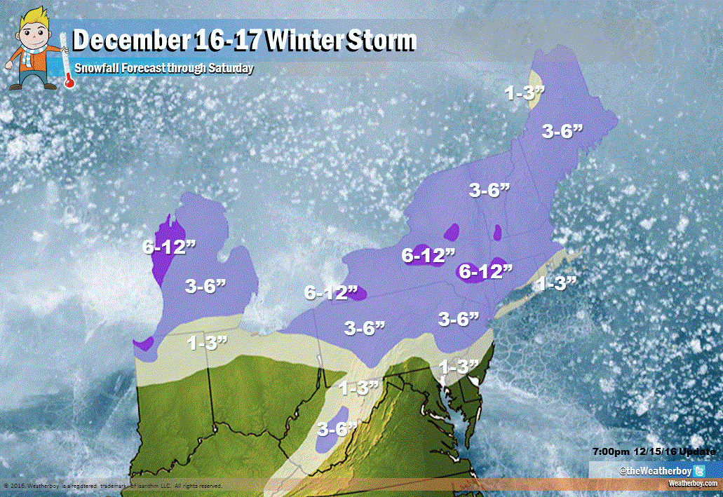
A large area of low pressure will bring snow, sleet, freezing rain, and plain rain to portions of the eastern US to end the week and begin the weekend. The center of the Arctic air mass responsible for today’s frigid weather in places like New York City and Philadelphia today will move from the Ohio River Valley this evening to Virginia around daybreak Friday. Winds will diminish slowly overnight; passing flurries and squalls will also die-off during the overnight hours.
Tonight will feature the coldest temperatures since last winter; it’ll also feature the coldest December readings in more than 10 years across much of the Mid Atlantic and New England regions. As an example, temperatures will drop to the low teens in much of northeastern Maryland, Delaware, New Jersey, and southeastern Pennsylvania. Readings will be colder yet –in the single digits– in the Pocono region, northwestern New Jersey, and upstate New York. With winds, wind chill factors will remain near zero with readings below zero in the higher terrain of the northeast.
Friday will be an extremely cold day with temperatures remaining below freezing all day. The Arctic high responsible for the cold conditions will slowly shift east, allowing a southwesterly flow to develop. A low pressure system will begin to take shape over the Plains and will move northeastward toward the Great Lakes region later Friday night into Saturday. This low will drag a warm front up the coastal plain on Saturday.
With cold air firmly in place Friday, precipitation that moves into the Mid Atlantic and Northeast will start as plain snow. But as that warm front moves up the coastal plain on Saturday, the snow will gradually mix with and change to sleet, freezing rain, and eventually plain rain as far north as southern New Hampshire.
Prior to the change-over to freezing and liquid precipitation, a few inches of snow will fall across portions of West Virginia, northeastern Maryland, northern Delaware, much of New Jersey, New York, Pennsylvania, and points north. Areas escaping the warm-up the longest will see the most snow; a widespread 3-6″ is expected there away from the coast. The Great Lakes will enhance heavier snowfall in western Michigan, northwestern Indiana, and parts of New York state.
On Saturday, the transition from snow to sleet to freezing rain and eventually plain rain will evolve from south to north. This transition should happen before breakfast on Saturday for Philadelphia and places south; it’ll happen by lunchtime around New York City and nearby areas. The change-over will occur later Saturday afternoon in southeastern new England. Frozen and freezing precipitation could be heavy right before the change-over to liquid precipitation.
A dry-slot will set-up later Saturday, leading to a temporary break in the precipitation along the I-95 corridor. Another wave of precipitation will approach on Sunday as a cold front associated with this weather system moves through. While most precipitation Sunday will fall in liquid form, it could change to sleet and snow before ending, especially north and west of the I-95 corridor in the northeast.
This weather will impact NFL football games this weekend; see how here.