The National Hurricane Center (NHC) in Miami, Florida has issued Hurricane and Storm Surge Warnings in advance of Francine’s expected arrival, a tropical storm today that’s expected to intensify into a hurricane before making landfall in Louisiana. The Hurricane Warning is in effect for the Louisiana coast from Sabine Pass east to Morgan City while the Storm Surge Warning is in effect from High Island Texas to the Mouth of the Mississippi River in Louisiana and includes Vermilion Bay. These types of warnings are issued for the likelihood of life-threatening conditions caused by a hurricane and residents in the warning area should active their hurricane action plan and rush storm preparations to completion.
A Storm Surge Warning means there is a danger of life-threatening inundation, from rising water moving inland from the coastline, during the next 36 hours in the indicated locations.
A Hurricane Warning means that hurricane conditions are expected somewhere within the warning area. A warning is typically issued 36 hours before the anticipated first occurrence of tropical-storm-force winds, conditions that make outside preparations difficult or dangerous.
A Tropical Storm Warning is also in effect for the areas between Morgan City and Grand Isle, from High Island to Sabine Pass, from the Mouth of the Rio Grande to Port Mansfield, and from La Pesca to the Mouth of the Rio Grande. A Tropical Storm Watch is in effect for the areas between Barra del Tordo to La Pesca Mexico, Port Mansfield to High Island Texas, East of Grand Isle, Louisiana to the Mouth of the Pearl River, including metropolitan New Orleans, as well as all of Lake Pontchartrain and Lake Maurepas. A Tropical Storm Warning means that tropical storm conditions are expected somewhere within the warning area within 36 hours while a Tropical Storm Watch means that tropical storm conditions are possible within the watch area, generally within 48 hours.
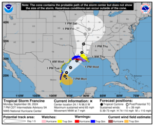
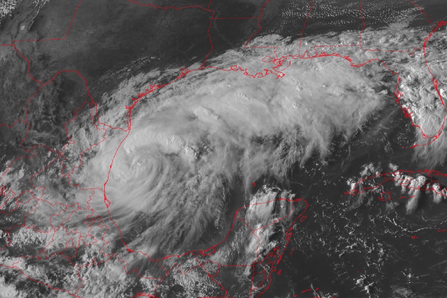
As of the latest advisory from the NHC, Francine was located roughly 145 miles south-southeast of the Mouth of the Rio Grande and about 425 miles south-south-west of Cameron, Louisiana. The storm had maximum sustained winds of 65 mph and was moving north-northwest at 7 mph. Minimum central pressure is down to 993 mb or 29.32″.
The NHC expects Francine will continue its north-northwest motion through this evening followed by a turn to the northeast with some acceleration beginning Tuesday. On the forecast track, Francine is anticipated to be just offshore of the coasts of northeastern Mexico and southern Texas through Tuesday, and nearing the Louisiana and Upper Texas coastline on Wednesday. While the storm’s maximum sustained winds remain near 65 mph now, the NHC says that significant strengthening is forecast over the next couple of days.
Hurricane conditions are expected within the warning area on Wednesday. Hurricane conditions are possible in the hurricane watch area on Wednesday, with tropical storm conditions expected by Wednesday morning within the warning areas. Tropical storm conditions are expected in the warning area in Mexico and south Texas through Tuesday afternoon. Tropical storm conditions are possible within the watch area along the northern coast of Mexico tonight. Tropical storm conditions are also possible along portions of the Texas coast in the watch area Tuesday and Tuesday night, and are possible in the watch area in eastern Louisiana on Wednesday.
The storm will create heavy rains that could lead to considerable flash and urban flooding. Total rainfall amounts of 4-8″ with localized amounts to a foot are possible from northeast Mexico northward over the far lower and far upper Texas coasts, across southern Louisiana, and southern Mississippi into Thursday morning.
A significant storm surge of 5-10′ is also possible in Louisiana. Residents in storm surge flood zones of the Texas, Louisiana, Mississippi, and Alabama coasts should heed the advice of local officials and evacuate if asked to. The deepest water will occur along the immediate coast near and to the east of the landfall location, where the surge will be accompanied by large and dangerous waves. Surge-related flooding depends on the relative timing of the surge and the tidal cycle, and can vary greatly over short distances.
The NHC writes, “Storm surge is not expected to pose a threat to the risk reduction system levees. However, there may be some overtopping of local levees.”
