Considerable flash flooding will be possible in Texas in the coming days, prompting the National Weather Service and local authorities in the Lone Star State to take action.
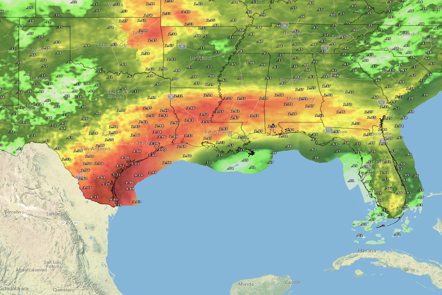
Heavy rainfall will return to portions of south Texas Monday evening and continue through the mid week, resulting in the potential for locally considerable flash and urban flooding.
According to the National Weather Service, flash and urban flooding will also be possible through Monday across much of the Texas Hill County and East Texas ahead of the heaviest rain arriving Monday night.
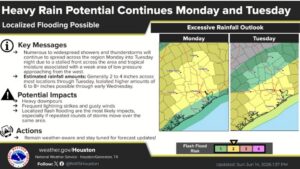
Rainfall totals of 4-8″ are expected with locally higher amounts through to Wednesday; the highest totals are expected across south Texas and along the Texas coast.
“Flash and urban flooding could pose a significant threat to life and property,” warns the National Weather Service.
Fortunately, drier antecedent conditions will help to mitigate widespread river flooding from this event. But even so, the National Weather Service cautions that minor and isolated moderate river flooding will be possible from these heavy rains.
The Texas Division of Emergency Management (TDEM) wants people in Texas to be prepared. They wrote on X, “Most of Texas faces a threat of heavy rainfall and flash flooding. State emergency response resources activated by TDEM at Gov. Abbott’s direction continue to remain available to support local response operations. Monitor your local forecast, pack a go-kit, and make a plan.”
The Galveston/Houston office of the National Weather Service explains the forecast set-up in their latest forecast discussion: ” Rain chances really begin to increase early on Monday, as a frontal boundary drifts southward and provides a renewed focus for convection. Given the abundance in moisture , rainfall will be heavy at times and the flash flooding potential will increase, especially in areas that see the multiple rounds of heavy rain.”
“This will increase further by Tuesday, as the aforementioned boundary drifts further south and our moisture continues to increase. Although there isn`t a lot of upper level forcing, instability will remain high so robust thunderstorms are still possible. In the more organized storms, rainfall rates could exceed 2 inches at times,” they add.
Due to the concern, a Flash Flood Watch has been issued for much of south Texas through to Wednesday morning.
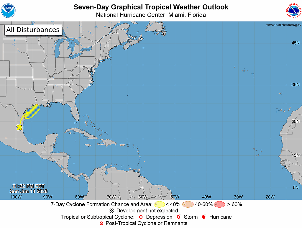
There is also tropical cyclone concern that is being monitored this week. While Tropical Storm Cristina dissipated over western Mexico days ago, its remnant moisture lingers over eastern Mexico.
The National Hurricane Center continues to track an area of concern over northeastern Mexico that could develop into a tropical cyclone in the coming days. The NHC has raised the odds to 30% of a tropical cyclone forming here; in their latest Tropical Outlook, they write, ” A trough of low pressure located over northeastern Mexico is producing disorganized shower and thunderstorm activity. Development is not expected during the next day or so while the trough remains inland and drifts northward over northeastern Mexico or southern Texas. The system is then forecast to move northeastward and could re-emerge over the northwestern Gulf of America late Tuesday or Wednesday, where environmental conditions may support some development around midweek.”
But like the Galveston/Houston National Weather Service office says, they are concerned about the flood threat over Texas anyway. The NHC says, “Regardless of formation chances, heavy rainfall and flash flooding are possible across portions of eastern and southern Texas and Louisiana this week.”
While computer forecast guidance is fairly consistent on this low developing and tracking eastward, there remains discrepancies in the location and timing of the surface low. If the system takes shape later in the week, the flood threat would stretch well beyond Wednesday for this part of the country.
The National Weather Service’s Weather Prediction Center echoes concerns for this flood threat. They write today, “As this feature pushes northeastward out of the mountains of Mexico towards south Texas, it will not only increase the low level inflow of tropical moisture, but will provide ample forcing to organize the storms into slow-moving lines of training cells that track northward/northwestward with time up the Rio Grande. Any and all storms will have impressive amounts of moisture to work with to produce heavy rain given the fully saturated lower atmosphere all the way up to the tropopause per some forecast soundings.”
