A Tropical Storm Watch has been issued for portions of the Texas and Louisiana Coast ahead of Potential Tropical Cyclone #1 which could briefly become Tropical Storm Arthur before impacting the Gulf Coast. In addition to the Tropical Storm Watch issued by the National Hurricane Center, National Weather Service offices in Texas and Louisiana have been busy issuing Flash Flood Watches and Warnings for extremely heavy rainfall.
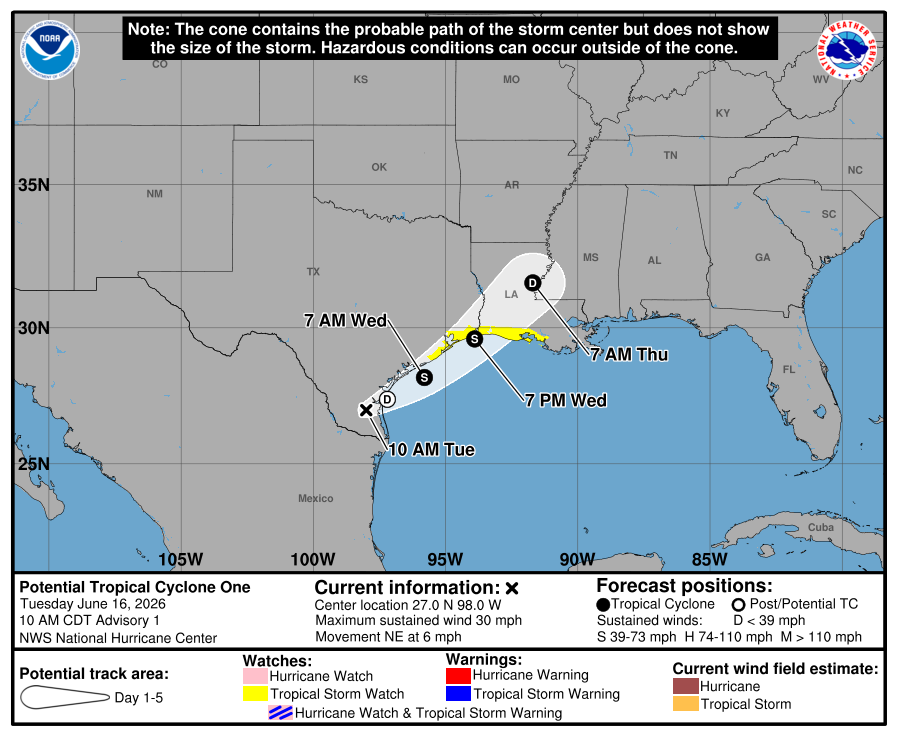
The disturbance that the National Hurricane Center (NHC) has been tracking for several days across the southern Gulf of America into northeastern Mexico has moved into southern Texas. While the system is producing plentiful convection, it still lacks a well-defined center. However, according to the NHC, most of the guidance suggest that it will move offshore tonight, and winds will increase to tropical-storm-force on Wednesday.
With tropical storm force winds arriving, advisories have been initiated on Potential Tropical Cyclone One by the NHC and Tropical Storm Watches have been issued for portions of the Upper Texas and southwestern Louisiana coasts. Regardless of whether the system becomes a tropical cyclone, heavy rainfall and life-threatening flash flooding will be the primary hazards with this system.
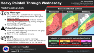
The National Weather Service (NWS) office in Houston/Galveston says, “Life-threatening flooding remains possible through Wednesday. An additional 4-10″ is possible.” Even with the storm not near the Houston/Galveston area yet, heavy rain has been soaking the Texas coast and rainfall rates have exceeded 2-5″ per hour in some locations.
The NWS adds, “Life-threating flash flooding will likely occur. Urban and low lying areas will be especially at risk as well. Rises in rivers, creeks and streams will result in minor river flooding at least. Risk of runoff continues to grow as additional rounds of rainfall saturate soils. Once again, Moderate Rainfall Risks are seldom issued, only when there is strong confidence that significant, life-threatening flash flooding could occur. Around 1 out of 5 fatalities from flooding occur on a
Moderate risk days”
A Flood Watch remains in effect for all of southeast Texas until Thursday morning; the same is true for much of Louisiana.
“Make sure to have multiple ways of receiving warnings and remain weather aware,” the National Weather Service wrote in their latest Forecast Discussion. “Do not attempt to drive through flooded roadways. TURN AROUND, DONT DROWN!”
In the first advisory issued by the NHC for this storm, they put the center of Potential Tropical Cyclone #1 about 65 miles southwest of Corpus Christi, Texas and about 360 miles southwest of Lake Charles, Louisiana. Maximum sustained winds are up to 30 mph while minimum central pressure is down to 1007 mb or 29.74″. The system is moving northeast slowly at 6 mph.
In advance of the storm, a Tropical Storm Watch has been issued for the northwestern Gulf Coast from Sargent, Texas to Morgan City, Louisiana. A Tropical Storm Watch means that tropical storm conditions are possible within the watch area, in this case within 24 to 36 hours.
The NHX expects that the disturbance will move offshore the Texas coast tonight or early Wednesday, move roughly parallel to the upper Texas coast later on Wednesday and move back inland in extreme eastern Texas or southwestern Louisiana late Wednesday or early Thursday. The disturbance is forecast to gradually strengthen and could become a tropical storm early on Wednesday. If that happens, it would be given the first name of the 2026 Atlantic Hurricane Season, Arthur. Weakening is anticipated on Thursday after the system moves back on land. Right now the NHC believes there’s a 60% chance the tropical cyclone will form.
