
Tropical Storm Arthur could form near Texas this week. The National Hurricane Center has been monitoring a disturbance for the last several days over the Gulf of America, the Bay of Campeche, and eastern Mexico; they now believe this disturbance has a 50-50 shot of becoming a tropical storm in the coming days. Whether the system develops into a tropical storm or not, one thing is certain: the National Weather Service says very heavy rain will soak south Texas.
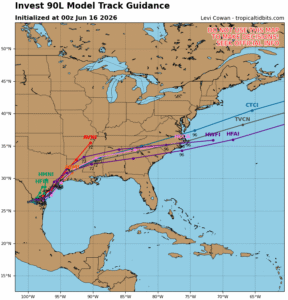
A trough of low pressure located over northeastern Mexico is producing a large area of disorganized showers and thunderstorms. According to the National Hurricane Center (NHC), development is not expected during the next day or so while the trough remains inland. However, the system could re-emerge over the northwestern Gulf of America late Tuesday or Wednesday, and environmental conditions there are marginally conducive for the formation of a short-lived tropical storm on Wednesday into Thursday.
If the system became a named tropical storm, it would be called Arthur as the first named storm of the 2026 Atlantic Hurricane Season.
“Regardless of tropical cyclone formation, interests across southern and eastern Texas and portions of Louisiana and Mississippi should prepare for periods of intense rainfall over the next several days which could produce widespread, life-threatening flash, urban, and river flooding,” warns the National Hurricane Center, adding that “Gusty winds and coastal flooding are also possible along portions of the northwestern Gulf Coast, and Tropical Storm Watches or Warnings could be required on Tuesday.”
Across the Texas Gulf Coast, National Weather Service offices are warning of the flood threat whether or not a storm forms. The Houston/Galveston National Weather Service office says, “Periods of moderate to heavy rain and storms expected through at least Thursday. There is an increased danger to lives and property due to flash flooding. Life-threatening flooding possible somewhere in the Flood Watch area. Rainfall amounts of 4-7″ expected, with isolated totals of 10″+. Rainfall rates will range from 2-5″/hour.”
With a flash flooding threat, the National Weather Service is reminding people of flood hazards. “Flash flooding is a rapid, highly dangerous hazard that can catch people off guard whether they are driving or camping,” says the National Weather Service. They emphasizes the importance of proactive preparedness by advising people to enable mobile weather alerts, immediately seek higher ground when warned, and never attempt to cross flooded areas by foot or in a vehicle.
