
Tropical Storm Olana has formed in the Central Pacific Ocean and the National Weather Service and National Hurricane Center are warning that flooding rains from the storm could impact the state of Hawaii in the coming days. Hawaii continues to recover from numerous tropical cyclone impacts in recent weeks, with Lala, Lowell, Moke, and Nolo bringing rain, wind, and rough surf to the state since August.
In their latest Hydrologic Outlook, the National Weather Service in Honolulu on the Hawaiian island of Oahu writes, “A significant pattern change is expected Monday night through at least Thursday as deep tropical moisture is brought north. A combination of surface lows and troughs will bring exceptionally moist air over the eastern end of the state beginning Monday night and extending to all islands Tuesday. Heavy rain and thunderstorms are possible throughout this period.” The National Weather Service says that computer forecast models have not converged on details yet, so exact locations, timing, and rainfall amounts are not yet certain.
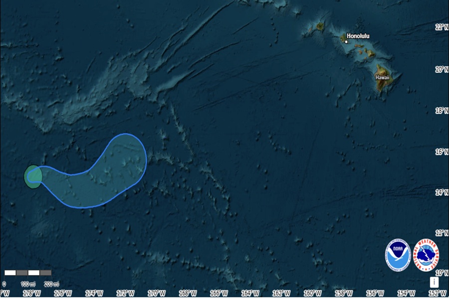
While Tropical Storm Olana has formed, its center of circulation is not expected to impact Hawaii; in fact, the latest advisory from the National Hurricane Center forecasts that the structure of the storm will collapse in the coming days. However, it is very likely that deep moisture associated with the storm will impact Hawaii.
According to the latest update from the National Hurricane Center, Tropical Storm Olana was located about 580 miles west-southwest of Johnston Island. With maximum sustained winds of 40 mph and a minimum central pressure of 1002 mb or 29.59″. Olana is moving toward the east-northeast near 8 mph and a general eastward motion is expected for the next several days. The National Hurricane Center says some slight intensification is possible later today, but weakening is forecast to begin on Monday.
The tropical cyclone will join forces with other weather disturbances to set the stage for soaking rains in Hawaii. On Monday afternoon, a low to the north of Hawaii will drift slowly southeast, both aloft and at the surface. At the same time, Tropical Storm Olana and a new surface low will form to the south and west of Hawaii. A trough will connect these lows and the resulting southerly winds will bring deep tropical moisture northward as this trough moves north toward and then through the state Monday night through Thursday.
Heavy rain and thunderstorms will be possible through this period over most of the state, but models are slow to converge on areas of maximum concern. A Hydrologic Statement describing the
concern for flooding was issued yesterday afternoon. Yesterday it appeared likely that the heaviest rains would be somewhere between Oahu, Maui, and Hawaii islands; today, the same models suggest the heaviest rain will be closer to Kauai and Oahu. With a lack of run to run continuity in the forecast output, there is low confidence where the heavy rain and greatest flood threat will be. Once the models continue to show the potential for heavy rain in the same area, the National Weather Service says they will issue a Flood Watch for potentially impacted islands.
In addition to flooding rains from the deep tropical moisture streaming into Hawaii, upper level winds may be just strong enough to enable the development of organized convection. These thunderstorms may become severe and contain damaging wind gusts, the possibility of hail, and isolated tornadoes or water spouts. The overall weather system won’t produce damaging winds, but these localized thunderstorms that develop inside the storm could create pockets of danger or damage at times.
By Thursday afternoon, the system and its moisture should move out, allowing Hawaii to recover again from yet another tropical system in the Pacific during a hyperactive El Nino weather phenomena.
