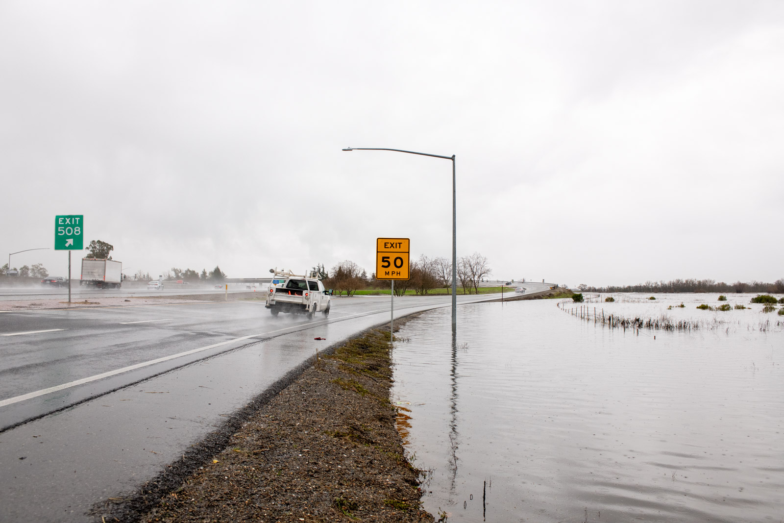
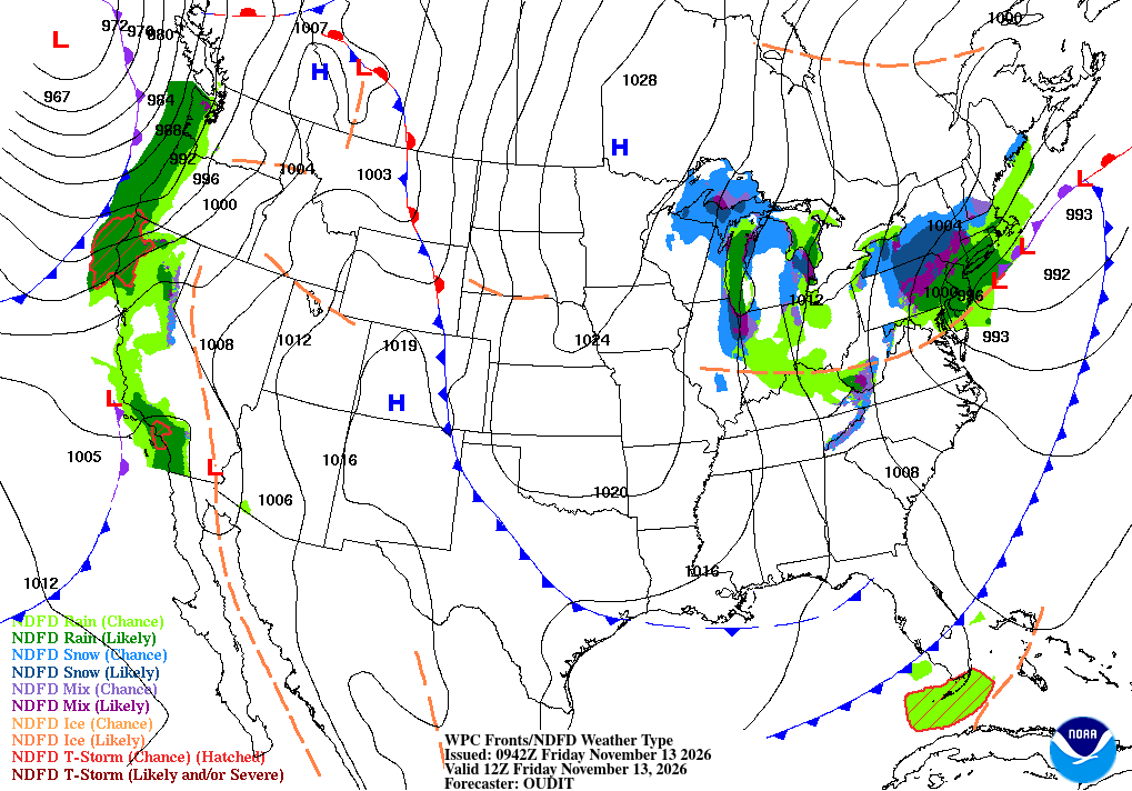
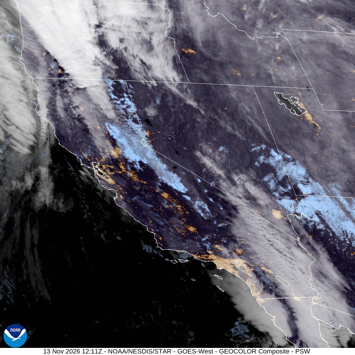
The first in a series of Pacific storms pushed into California on Friday, Nov. 13, bringing heavy mountain snow, gusty winds, dangerous surf and bursts of rain to a state that has seen little rain so far this fall.
The National Weather Service posted winter storm warnings across the Sierra Nevada, wind advisories in the Sacramento Valley and high surf and coastal flood warnings along the Central Coast. Forecasters said the storm would hit hardest from late Friday morning into early Saturday before a brief break, with another system due Sunday into Monday.
The weather service office in Sacramento said in its Friday morning forecast discussion that a pair of storms would bring widespread rain, heavy mountain snow and gusty to strong southerly winds through Monday. It said the first storm “will be the stronger system in terms of winds and heavy snow.”
Mountain Travel Expected to Turn Difficult
In the northern Sierra, a winter storm warning runs from 10 a.m. Friday to 10 a.m. Saturday for elevations above 6,000 feet, including Interstate 80, U.S. Highway 50 and state routes 4 and 108, as well as Lassen Volcanic National Park. The Sacramento office forecast 6 to 12 inches of snow above 6,000 feet, with up to 18 inches at the highest peaks and about 2 inches possible down to 5,000 feet. Winds could gust to 60 mph, it said.
“Travel could be very difficult,” the warning said. “The hazardous conditions will impact the Friday evening commute.”
The weather service office in Reno, Nevada, which covers the Lake Tahoe area, forecast heavy wet snow of about 12 inches above 7,000 feet and up to 20 inches along the crest west of the lake. It warned of wind gusts of 70 to 90 mph over ridges and 45 to 55 mph in Truckee and lakeside communities, with waves of 2 to 5 feet on Lake Tahoe.
Reno forecasters said heavy snow would target the Tahoe Basin between 2 p.m. and 8 p.m. Friday and Mono County between 3 p.m. and 10 p.m., with snowfall rates of 1 to 2 inches an hour and up to 3 inches an hour on the Sierra crest. The office warned that “Sierra cement,” its term for dense wet snow, combined with strong winds “could cause damage to trees and power lines.”
Farther south, the weather service office in Hanford posted a winter storm warning for Yosemite National Park outside the valley floor and for Kings Canyon and Sequoia national parks. It forecast up to 20 inches of snow above 6,000 feet and gusts as high as 50 mph from 10 a.m. Friday until 4 a.m. Tuesday, saying the conditions would affect both the Friday evening and Monday morning commutes.
Caltrans said it had prepared for the storm. “Our maintenance crews are prepped, they are ready to go,” Jeremy Linder, a public information officer for Caltrans District 3, told ABC10 in Sacramento. He urged drivers to carry chains and emergency supplies.
“You don’t know if it’s going to be 30 minutes or if it’s going to be several hours,” Linder said. He noted that the speed limit on Interstate 80 drops to 30 mph when chain controls are in effect.
AccuWeather projected 6 to 10 inches of snow around Donner Pass, which sits near 7,200 feet, with snow beginning later Friday afternoon.
The snow is welcome news for ski areas. Northstar California Resort is hoping for about 2 feet of fresh snow before its scheduled opening next Friday, spokesperson Dennis Baggett told CBS Sacramento. “When it lines up, like it’s about to with the snow coming just in time for opening, it really makes us excited for the season,” he said.
Valley Wind, Rain and Thunderstorms
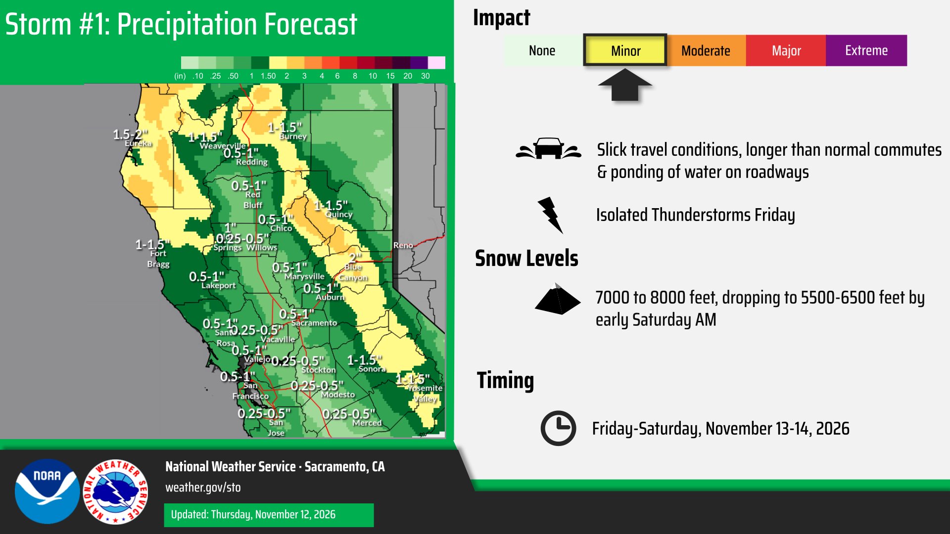
In the Sacramento Valley and the Delta, a wind advisory runs from 4 a.m. to 7 p.m. Friday, with south winds gusting to 35 to 45 mph. Forecasters said there was a 60% to 80% chance of gusts topping 45 mph near Red Bluff.
The Sacramento office forecast 0.25 to 0.75 inch of rain in the valley and Delta and up to nearly 3 inches in the mountains and foothills, with higher amounts possible under thunderstorms. Forecasters put the chance of thunderstorms at 15% to 25% Friday afternoon and evening and said strong wind shear raised “some potential for severe storms” capable of frequent lightning, gusty winds and small hail.
A separate flood advisory for abnormally high tides covers low-lying areas along San Pablo Bay, the Carquinez Strait and Suisun Bay in Solano County until 4 p.m. Friday. The weather service forecast a tide 1 foot above normal at Port Chicago at 2:56 p.m. Friday.
Sacramento County officials said dry ground should absorb much of the early rain. “If we end up seeing storm after storm after storm and the ground becomes saturated and can’t hold that water, then it’s time to become nervous,” county spokesperson Matt Robinson told CBS Sacramento.
AccuWeather said San Jose had received only 0.27 inch of rain since the start of September, 22% of its historical average for that period.
Burn Scar Flood Advisory in Los Angeles County
Southern California got an early start. Scattered heavy showers moved over the Eaton burn scar around 3:40 a.m. Friday, and the weather service office in Los Angeles posted a flood advisory for northeast Pasadena, Altadena and Sierra Madre until 5:45 a.m. Radar estimated rainfall rates of 0.5 to 0.7 inch an hour, and the office said “minor flooding or shallow debris flows” were ongoing or expected.
In San Diego, Orange and Riverside counties, thunderstorms prompted a flood advisory until 6:15 a.m. for urban and small stream flooding. The weather service said 0.25 to 0.5 inch of rain had fallen and listed Chula Vista, Irvine, Oceanside, Carlsbad, El Cajon and San Clemente among the places that could see flooding.
The Los Angeles office said a cold front would bring a second round of light to moderate rain Friday night into Saturday morning. Rainfall totals through Saturday morning were expected to range from 0.25 to 0.75 inch for most areas, with isolated totals near 1 inch.
Surf Could Damage Piers and Roads
Along the coast, long-period swells are expected to build through the weekend. The Los Angeles office forecast breaking waves of 18 to 25 feet on west-northwest-facing beaches of San Luis Obispo and Santa Barbara counties, with a high surf warning from 9 p.m. Friday to 3 a.m. Sunday and a coastal flood warning from 3 a.m. to 6 p.m. Saturday.
Forecasters said the Central Coast faces the highest risk, with the potential for localized damage to piers, roads and structures in the most vulnerable areas. They cited breaking waves at the Morro Bay Harbor entrance and near the Pismo and Cayucos piers, along with flooding of sandy beaches such as Oceano Dunes State Park.
Off the North Coast, the weather service office in Eureka said a “very large” northwest swell of about 28 feet would reach coastal waters Friday evening.
More Storms on the Way
Forecasters said the stormy pattern will continue. The Reno office said a colder system will bring mountain snow and valley rain Sunday night through Tuesday, with 3 to 8 inches possible on Sierra passes. The Los Angeles office forecast more rain Monday and again Wednesday and Thursday.
In Plumas County, the weather service has retired special flash flood thresholds for the Dixie Fire burn scar because enough recovery has been observed, The Plumas Sun reported, though officials cautioned that mud and rocks can still move in heavy rain.
