Image: NOAA/National Weather Service Melbourne
The St. Johns River west of Cocoa rose past its highest level on record early Thursday as bands of heavy rain kept moving ashore along Florida’s Space Coast. The National Weather Service warned the river would stay above record levels into the weekend.
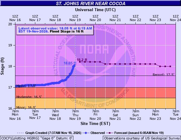
Image: NOAA/National Water Prediction Service
The river gauge near Cocoa read 18 feet at 5:15 a.m. EST Thursday and 18.05 feet an hour later, according to the weather service and its National Water Prediction Service. The previous record was 17.55 feet, set Oct. 11, 1953, Newsweek reported, citing weather service data. Flood stage at the gauge is 16 feet. Forecasters expected a crest near 18.2 feet Thursday afternoon.
Flooding along the St. Johns was already underway earlier this week. What’s new Thursday is the record crest, more flash flood warnings in Brevard County and a possible weekend coastal storm.
“Ongoing extreme rainfall over the headwaters of the St. Johns River has caused the river near Cocoa to rise through Major Flood Stage and has now quickly passed record flood stage,” the weather service office in Melbourne said in a 6:11 a.m. flood statement. “Additional heavy rainfall over the next 48 hours will continue to produce river rises above record flood levels through late week and into this weekend.”
Homes and Roads in the River’s Path
The weather service said water enters homes along the river in the Lake Poinsett area west of Cocoa once the river reaches 17.2 feet. The same applies to low-lying homes in the Silver Pines subdivision in Rockledge and the Shakespeare Park area of Cocoa. The river is now well above that level.
At that stage, the Providence Road area west of Cocoa becomes impassable, cutting off access to homes along Mullet Lane and Bass Road, the agency said. Docks flood and water reaches the parking lot at Lone Cabbage Fish Camp.
Brevard County officials said they had prepared for a flood that could last several days.
“We’ve had time to prepare, we’ve had time to get sandbags out to our residents,” Don Walker, communications director for the Brevard County Emergency Operations Center, told Spectrum News 13. “We’ve had time to set up our emergency operations center — we’re ready to open shelters if the need happens.”
Flash Flood Warnings Overnight
A flash flood warning issued at 4:50 a.m. covered central Brevard County. The weather service said radar showed 4 to 6.5 inches of rain had fallen in the past 12 hours and that 3 to 5 more inches were possible. The agency called the flooding life-threatening for places including Titusville, Cocoa, Cocoa Beach, Merritt Island and Port St. John. That warning ran until 7:45 a.m.
A second flash flood warning went out at 6:39 a.m. for southeastern Brevard County, including Palm Bay and Melbourne. It was in effect until 9:45 a.m. Forecasters said 1 to 3 inches had already fallen there, with 1 to 3 more inches possible.
Florida Today reported that about 15 inches of rain had fallen at Port Canaveral. The newspaper said Brevard Public Schools and Florida Tech had canceled classes for the day.
Brevard County Emergency Management urged people to stay home and off the roads if possible and never to drive through flooded streets. The county said Thursday morning that flooding had forced it to close its landfills for the day. It also asked residents to cut back on water use, saying heavy rain and flooding can strain the wastewater system and cause backups.
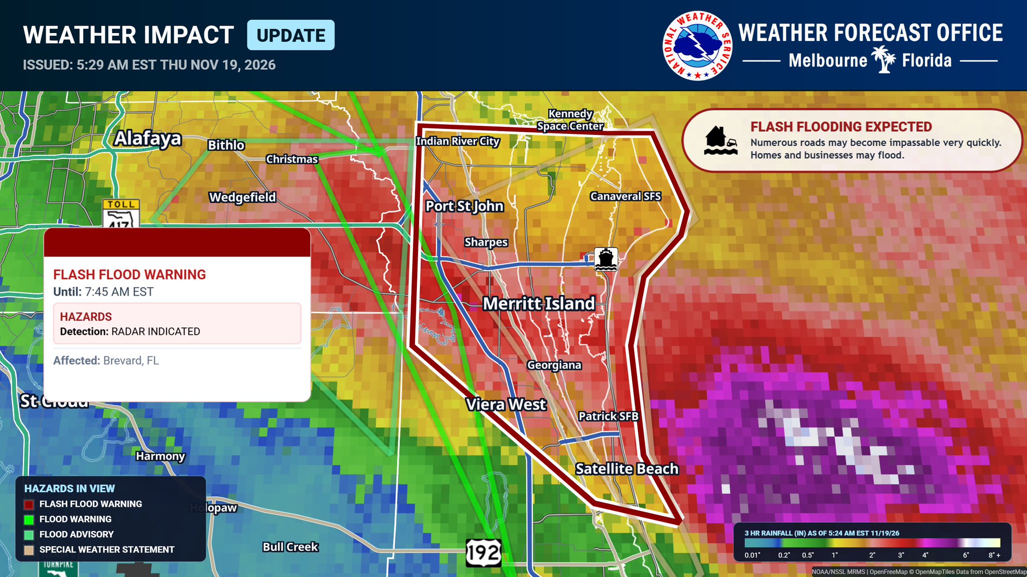
Image: NOAA/National Weather Service Melbourne
Flooding Along the River
Flood warnings were also in effect Thursday at several gauges downstream as the St. Johns flows north through Seminole, Volusia and Lake counties.
Near Geneva above Lake Harney, the river was at 9.4 feet early Thursday, in moderate flood. The weather service expects it to reach major flood stage overnight Thursday into Friday morning and to rise to about 10.4 feet by Sunday. At 10.5 feet, the agency said, water covers many secondary roads near the river, so some homes can be reached only by boat or high-clearance vehicle.
Downstream, the river near Sanford and near DeLand was in minor flood Wednesday evening, with slow rises expected into next week. At Astor, the river was in moderate flood and forecast to keep rising into Monday. Forecasters said strong onshore winds were pushing water up the river there.
More Rain in the Forecast
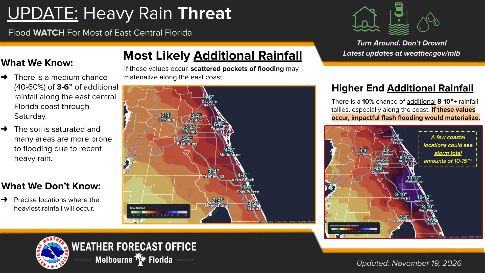
In its Thursday morning forecast discussion, the Melbourne office said 3 to 6 inches had already fallen near the coast from Indian River County north through Brevard and Volusia counties. Another 4 to 8 inches is possible in some of those areas through Friday night. Isolated totals above 15 inches are “within reach,” the office said, especially near the coast.
The Weather Prediction Center has a moderate risk of excessive rainfall, level 3 of 4, along parts of the east-central Florida coast through Friday. Most of the interior is under a slight risk, level 2 of 4. A flood watch covers most of east-central Florida through 7 p.m. Friday. The Jacksonville office has a separate flood watch for northeast Florida, where it forecast 3 to 6 inches, with local amounts up to 12 inches.
Strong onshore winds are adding to the trouble. Sustained winds of 15 to 25 mph were gusting to 35 mph, with some gusts near 40 mph at the coast, the weather service said. A high surf advisory runs through Saturday. The agency warned of rough, pounding surf, moderate to locally major beach erosion and a high risk of rip currents.
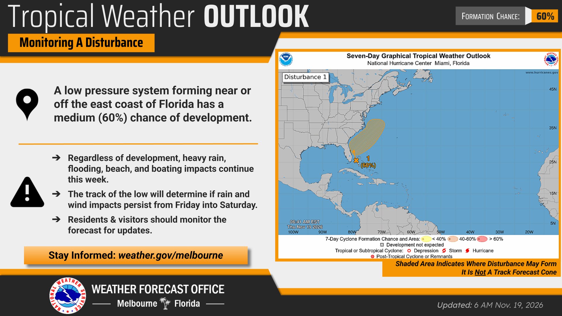
Image: NOAA/National Weather Service Melbourne
Low Pressure May Form Offshore
In its 7 a.m. EST tropical weather outlook, the National Hurricane Center said a non-tropical low was expected to form along a front near the northwestern Bahamas on Friday. The center said the system could become a subtropical or tropical storm as it moves north or northeast near or just off the southeastern U.S. coast through the weekend.
The hurricane center gave the system a 20% chance of forming within 48 hours and a 60% chance within seven days. Regardless of development, the center said, strong winds, dangerous surf and coastal flooding are likely along portions of the Southeast and mid-Atlantic coasts into early next week.
The Melbourne office said reconnaissance aircraft were being scheduled for the weekend. It said it was still unclear how close the low would come to Florida’s east coast. A track closer to the coast would bring more rain and wind, while a track farther offshore could pull drier air into the region this weekend, forecasters said.
If the low moves away as models suggest, rain chances should fall to 25% to 50% Saturday, with drier weather Sunday into Monday. Even so, the weather service said the St. Johns would keep rising for a while. The Melbourne office said extensive flooding along the river would continue because of “exceptional rainfall in the upper reaches of the basin over previous weeks.” It said more heavy rain would push river levels higher into the weekend, early next week and beyond.
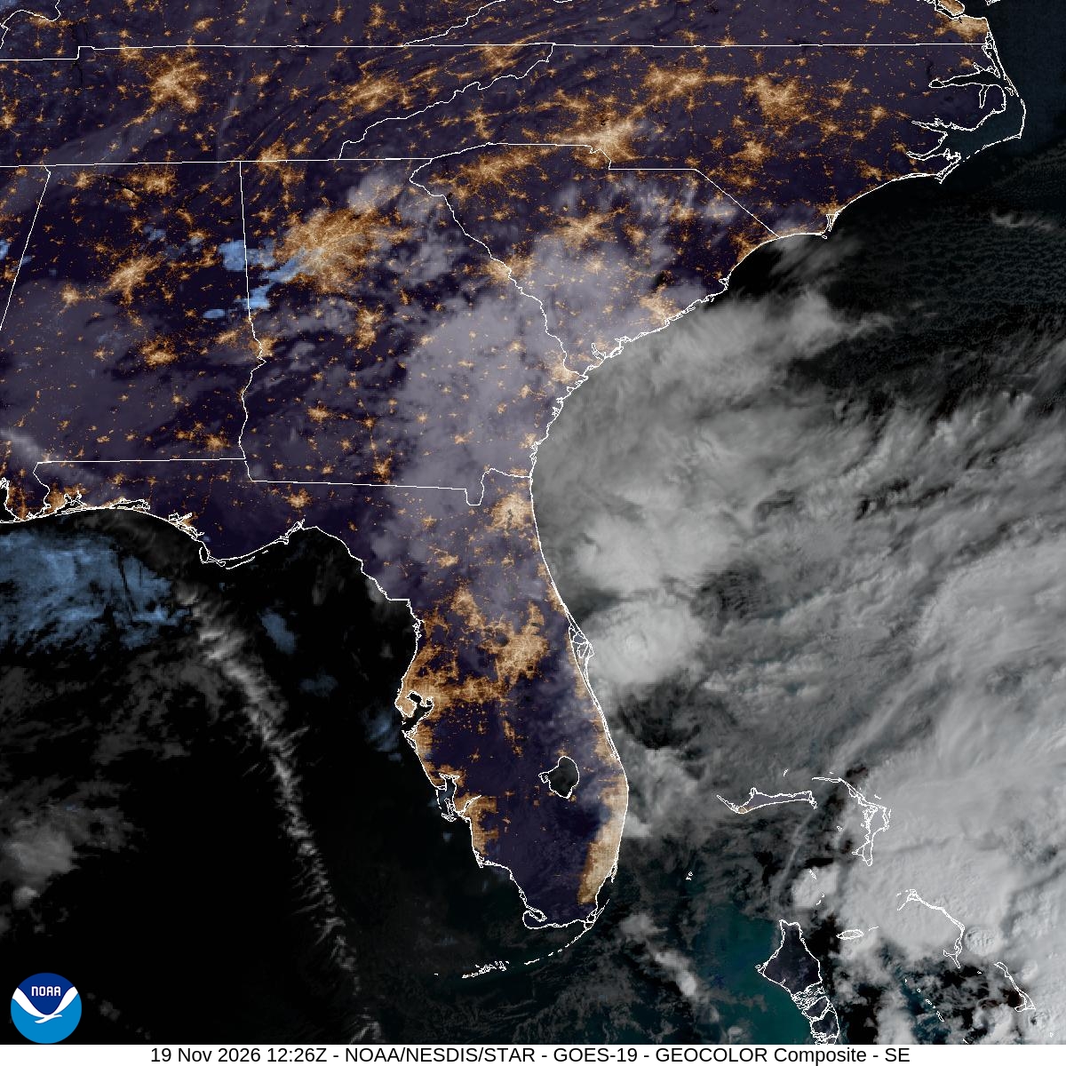
Image: NOAA/NESDIS/STAR
Second Flood in a Month
This flooding comes soon after another one. WKMG-TV reported Thursday that people in Palm Bay were bracing for more water two weeks after what the station called historic, deadly flooding in parts of Brevard County.
“Turn around, don’t drown,” the weather service said, noting that most flood deaths happen in vehicles.
The next river statement from the Melbourne office was scheduled for 6:15 p.m. EST Thursday.
