A complex, volatile weather pattern will produce a significant winter storm followed by a dramatic warm-up in the eastern United States.
In the short-term, Old Man Winter will be dominating the pattern and the news over the next week. Three distinct systems will bring snow to an area that hasn’t seen much of it this winter.
The first system, known as a clipper system, will drop light snow across northern Pennsylvania, New Jersey, the New York City metro area, and southern New England on Friday.
The second system will drop much further south, bringing snow to portions of Tennessee, North Carolina, and southern Virginia.
The third but likely to be largest of the storms could bring very heavy snow to portions of the I-95 corridor from Philadelphia to Boston, with the heaviest snow possible over the northern half of New Jersey, northeastern Pennsylvania, the New York City metro region, Connecticut, Rhode Island, and southeastern Massachusetts.
While snow shovels will be in use for many, the warm-up advertised earlier is still on its way …and will be arriving in a big way.

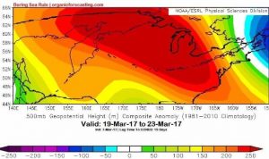
Joseph Renken, founder of the Bering Sea Rule (BSR) said, “When we look at what happened in the Bering Sea from about February 22nd into early March, a huge ridge dominated the region and was centered over the International Date Line (IDL) for those 10 days or so. That tells us a ridge will develop over the United States mid to late next week and will last well into late March. In our research, we have found that the IDL teleconnects to a line found from New Orleans stretching due north to the Canadian border. Thus, the ridge should be centered in that approximate region.”
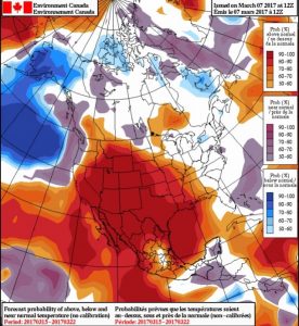
Warm weather develops under a ridge as the jet stream is pushed well to the north while abundant sunshine warms the land. Temperature departures will be very positive as the ridge takes hold and strengthens. That sets up an interesting battleground in the Northeast, especially in New England, as we see a clash between winter and spring. Much below average temperatures will be the rule in New England the next week or so. Right behind this Arctic air, though, temperatures will rebound to much above average reading in a matter of a few days.

“It now seems like after the third and final snow threat early to middle part of next week, warm air will flow into the Northeast, including New England, late next week, around the 16th or a bit afterwards. The issue with New England is that the axis, or center, of the ridge will be centered further west than the huge ridge that was found in the East in late February. This leaves the region vulnerable for backdoor cold fronts,” says Renken.
A backdoor cold front is a cold front that moves from northeast to southwest, instead of the normal northwest to southeast. Thus, the front can be described as “sneaky”, or coming through the “backdoor”, as meteorologically you look for cold front to approach from the northwest. Factors that make New England especially susceptible to backdoor cold fronts are their northern latitude and being near a source of cold air (the chilly north Atlantic Ocean and southeastern Canada). Early spring is the prime season for backdoor cold fronts in New England.
Renken describes when he expects such backdoor fronts to arrive. “The threat for backdoor cold fronts for New England first appears around the 18th. The good news for warm weather fans is that the airmass behind this backdoor cold front shouldn’t be that cold nor will it stick around for long. By the 26th of the month, the threat for any lingering chill will be over and warm west to southwest breezes will send temperatures soaring to way above normal readings once again. “
The result in the of this tumultuous weather pattern will be quite the roller coaster for people in the northeastern US. Winter readings dominate after a cold front and associated wave of low pressure develops on it Thursday into Friday of this week. This cold sticks around until about the 14th or as late as the 16th, depending on your longitude (western areas seeing the warm-up first, New England seeing the warm-up last). Backdoor cold fronts look probable for New England and the mid-Atlantic regions a few days (starting around March 18th) after the warmth arrives and will cut short the mild weather. After about 4-7 days where the threat of chilly weather exists, the warm air moves back in and really means business. New England will see this anomalous warmth move in around the 26th while areas to the south and west will see the mild weather sooner than this.