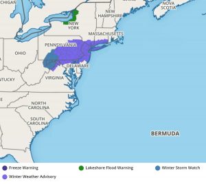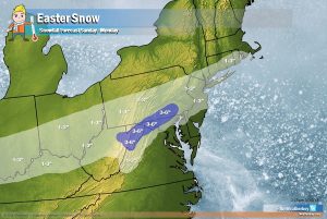
The National Weather Service has issued Winter Storm Watches and Winter Weather Advisories ahead of a snowstorm expected to dump several inches of snow later today, Easter Sunday. Another chance at a bigger snowstorm exists later in the new week as yet another winter storm threatens the Mid Atlantic in April.
A 1020mb high pressure system passing north of the Mid Atlantic will position itself north of new England late tonight and tomorrow morning. This high will allow cold air advection to seep southward into the region, but probably not until well after midnight, and towards the pre-dawn hours Monday. Meanwhile, a weak upper trough with some shortwave energy will move in from the west this evening, and buoyed by a vigorous upper jet, weak low pressure will form along the stationary boundary over the Mid-Atlantic just southwest of the Appalachians. That low lifts towards the Delmarva Peninsula after midnight, and then moves off the Mid-Atlantic Coast Monday morning.
With this snow event unfolding mainly late at night, daytime heating and sun angle will not have an impact on changing precipitation from snow to rain. There are also signals in the models that there’ll be banding of snow, and once that banding starts, it will be heavy enough to accumulate at a fairly rapid pace. Surface temperatures vary, with roadways milder than vegetative surfaces. As a result, snow accumulations will be uneven throughout the region, with more snow accumulating on grassy surfaces than on paved surfaces.

Nevertheless, accumulating snow is likely, and some areas could see 3-5″ of snow before the system exits Monday morning. As the sun rises Monday morning, some snow could mix with or change to plain rain, especially over southern portions of the snow. This will limit snow accumulations there. Precipitation will wrap up fairly quickly from west to east during the mid-morning hours Monday, with high pressure returning with fair weather.
With temperatures forecast to rise back into the 40s, with some places approaching 50, the snow won’t last. With milder temperatures and a higher sun angle, the snow should melt off throughout the region by Monday evening.
Once this system exits, eyes will begin to focus on the potential of yet another significant winter storm next weekend; this weather pattern could support more than 6 additional inches of snow in the Mid Atlantic by next Sunday.