The National Weather Service often looks to change or improve their forecast and warning products and today is no different: they announced starting in October later this year, they will begin issuing “Particularly Dangerous Situation” wording to some Blizzard and Ice Storm Warnings.
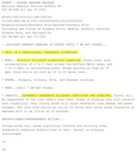
In a statement released by the National Weather Service (NWS) today, they wrote, “This language has been used in other NWS Watch and Warning Products to highlight when a specific weather event has a particularly high risk to life and property. Since this has been used effectively and the public and partner response to this proposed change has been overwhelmingly positive, the NWS is expanding the use of this language to Blizzard Warnings and Ice Storm Warnings.”
The NWS adds, “While blizzards and ice storms are already amongst the most impactful winter storms, there are variations in their severity. The use of this language will allow the NWS to alert the public and our partners when there is high confidence of a blizzard or ice storm that is of extreme and historic severity and poses an exceptional threat that is above and beyond the “typical” blizzard or ice storm.”
The NWS points out that there is no way for them to differentiate between more commonly observed blizzard and ice storm conditions and extreme conditions that are rarely observed. With this change, the NWS is aiming to improve the public response to winter warnings when these extreme conditions occur.
