On Saturday into the overnight hours of early Sunday Morning, Severe Thunderstorm Watches and Warnings and Tornado Watches and Warnings were issued, including a series of Tornado Warnings in central and northern New Jersey after 1 am. While significant wind damage did occur with many of these storms, the National Weather Service said no additional tornadoes touched-down in New Jersey Sunday morning. The National Weather Service, which has been busy confirming tornadoes elsewhere in New Jersey, Pennsylvania, and the broader Mid Atlantic in recent days, though, cautions that more severe weather including the threat of tornadoes is returning on Monday.
It was a rough night for many in central and northern New Jersey. And unfortunately, it looks like another round of severe storms, flooding rains, & even tornado threats return to the Mid Atlantic tomorrow. https://t.co/JmlXlVKCxD
— the Weatherboy (@theWeatherboy) August 14, 2023
New Jersey may break their record for the most tornadoes to be confirmed within a year. The two tornadoes to hit New Jersey on Thursday became the 12th and 13th tornado touch-down for the year, inching closer to the record 18 tornadoes that hit in 1989. Many states in the Northeast and Mid Atlantic, like New Jersey, have seen an unusually high number of tornadoes confirmed this year.
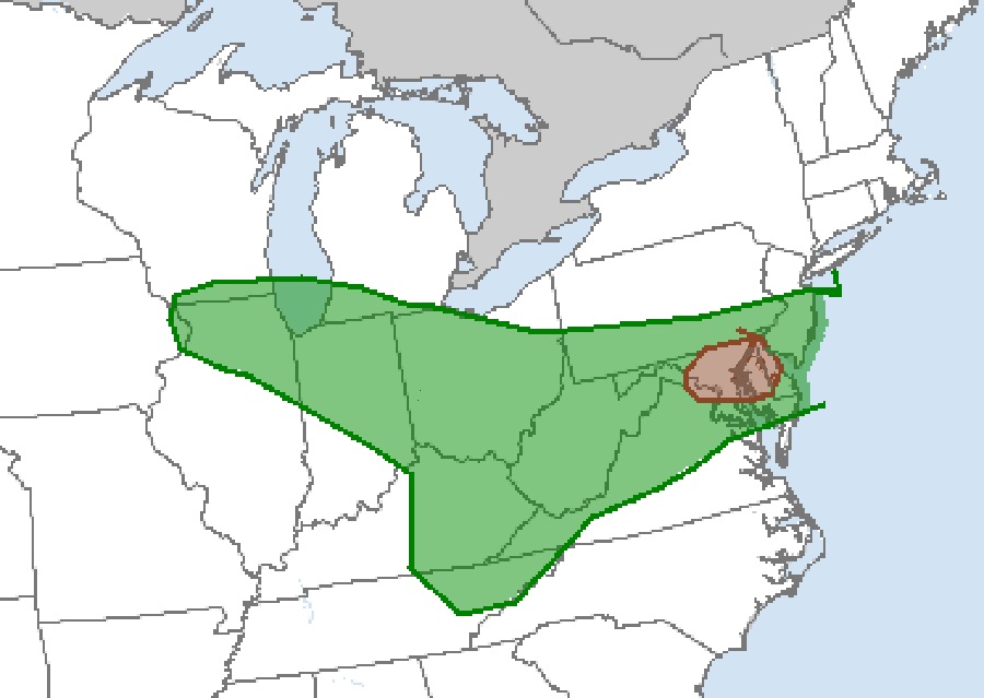
According to the National Weather Service’s Storm Prediction Center, central and southern New Jersey, southern Pennsylvania, northern Virginia, all of West Virginia, Maryland, and Delaware, eastern Kentucky, northeastern Tennessee, northern Indiana, much of Ohio, southern Michigan, and northern Illinois are at risk of tornadic thunderstorms tomorrow. Within this zone, the area near the I-95 corridor near Washington DC and Baltimore, including northern Delaware and northeastern Maryland is at greatest risk of tornadic thunderstorms.
While not everyone in these areas will see severe thunderstorms or tornadoes, the National Weather Service said atmospheric ingredients will be there to create an elevated level of risk.
In their latest Convective Outlook report, the National Weather Service’s Storm Prediction Center (SPC) says a shortwave trough in the mid and upper layers of the atmosphere oriented from the Upper Midwest to the southern Plains will develop eastward, extending from the eastern Great Lakes to the Mid-South by Tuesday morning. This will bring a belt of enhanced deep-layer southwesterly flow stretching across the Ohio Valley vicinity to the Mid-Atlantic and southern New England. A cold front slicing through this moist southerly flow will trigger thunderstorm development.
According to the SPC, moderate to strong vertical shear and steep low-level lapse rates will support a damaging wind risk from eastern Kentucky into West Virginia and into the Mid-Atlantic. Where low-level flow is expected to remain more southeasterly in the vicinity warm front in the Delmarva vicinity, a locally higher tornado risk is possible.

Another severe weather threat will persist across portions of southern New Jersey, Delaware, and eastern Maryland and Virginia on Tuesday. The extent of that severe weather will be dependent on how Monday’s severe weather unfolds.
Either way, soaking, potentially flooding rains are possible with slow moving thunderstorms and rain showers from this weather system throughout the Mid Atlantic.
