• Skip to primary navigation
  • Skip to main content
  • Skip to primary sidebar

Weatherboy

Weatherboy Weather News, Maps, RADAR, Satellite, and Forecasts.

  • Local
  • Earth Science News
  • RADAR
  • Current Warnings
  • Satellite
  • Current Maps
  • Forecast Maps
  • Video

Shaking Reported from Earthquake Northeast of Atlanta, Georgia

by Weatherboy Team Meteorologist - July 29, 2026

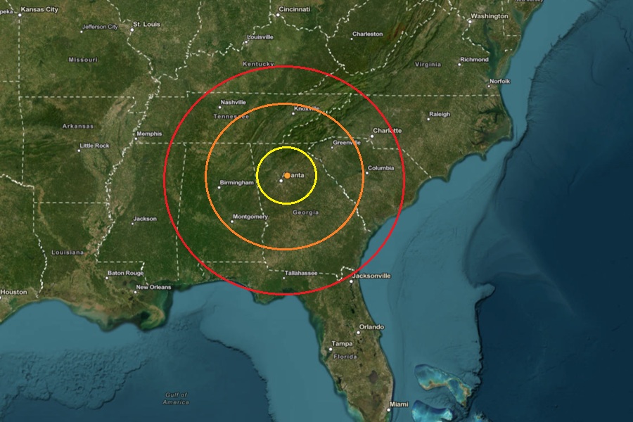
The epicenter of today's earthquake is at the orange dot inside the colored concentric circles on this map.  Image: USGS
The epicenter of today’s earthquake is at the orange dot inside the colored concentric circles on this map. Image: USGS

People have reported to USGS they felt shaking from an earthquake which struck north east of Atlanta earlier today. According to USGS, at 11:01 am this morning, a relatively weak magnitude 2.3 earthquake struck from a depth of 4.6 km near the town of Lilburn, Georgia which is about 25 miles northeast of downtown Atlanta, Georgia. There were no reports of any damage or injuries.

According to USGS, earthquakes with a magnitude of 2.0 or less are rarely felt or heard by people, but once they exceed 2.0 more and more people can feel them. While damage is possible with magnitude 3.0 events or greater, significant damage and casualties usually don’t occur until the magnitude of a seismic event rises to a 5.5 or greater rated event.

This map illustrates earthquake activity in and around Georgia cataloged by the USGS between 1903 and 2020. Image: Georgia Earthquake Awareness Guide 2020

According to Georgia’s Emergency Management and Home Security Agency (GEMA), approximately 15 percent of the world’s earthquakes are scattered over areas like Georgia that lack clearly defined active faults. Although earthquakes in Georgia are comparatively rare, scattered earthquakes caused significant damage and are an important consideration for homeowners. Georgia’s northwest counties, South Carolina border counties, and central and west central Georgia counties are most at risk.

GEMA recommends that people in Georgia plan for the risk of damaging earthquakes, especially if they’re in the northern Georgia counties of Bartow, Catoosa, Chattooga, Dade, Fannin, Floyd, Gilmer, Gordon, Murray, Pickens, Rabun, Towns, Union, Walker, and Whitfield, the South Carolina border counties of Burke, Chatham, Columbia, Effingham, Elbert, Lincoln, Richmond, and Screven, and central and west-central counties of Twiggs, Bibb, Jones, Baldwin, Hancock, Greene, Putnam, Butts, Jasper, Newton, Morgan, Walton, Harris, and Muscogee.

GEMA writes, “It’s important to be aware of your earthquake risk and to know how to protect yourself.” They encourage people to take a moment now to learn basic steps they should take before, during, and after an earthquake.


Primary Sidebar

Sponsored Ad

Search

Latest News

  • Kilauea Volcano Erupts as Hurricane Fausto’s Remnants Pass Hawaii
  • Shaking Reported from Earthquake Northeast of Atlanta, Georgia
  • Experimental Explosion Unleashed off Florida Coast; No East Coast Tsunami Threat
  • Bullseye of Heavy Rain / Flood Threat over New Jersey, New York, Connecticut
  • Hurricanes Fausto & Genevieve To Dodge Hawaii But Pound Island with Rough Surf
  • Weak Earthquake Rattles Southeastern Tennessee During Overnight Hours
  • Hurricane Fausto Forecast to Dodge Hawaii But Bring Dangerous Surf
  • Hurricane Strengthens, Heads to Hawaii, All While Volcano About to Erupt
About | Careers | Contact | Contests
Terms | Privacy | Ad Choices
Weatherboy is a (R) Registered Trademark of isarithm LLC, All Rights Reserved.
All content herein is Copyright by Isarithm LLC 1997-2022

Insert/edit link

Enter the destination URL

Or link to existing content

    No search term specified. Showing recent items. Search or use up and down arrow keys to select an item.