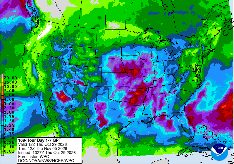
Arizona faces two rounds of heavy rain in three days starting Friday, and forecasters warned that storms falling on ground still saturated from last week’s destructive flooding could quickly send water racing through washes, creeks and low-water crossings from metro Phoenix to the Mogollon Rim.
The National Weather Service issued flood watches for Friday covering the Phoenix metro area, rural Maricopa County, western Pinal County and parts of Gila and Yavapai counties. A second, longer-lasting storm fed by an atmospheric river is expected Saturday night into Sunday, and the weather service office in Phoenix said a “more expansive” flood watch will likely be needed for that event.
“Wet weather in on its way with two weather events Friday through Sunday, both of which could produce heavy rainfall,” the Phoenix office said in its forecast discussion early Thursday.
Key Takeaways
1. Flood watches cover metro Phoenix, rural Maricopa County, western Pinal County and parts of Gila and Yavapai counties on Friday, when storms could produce rainfall rates of 1 to 2 inches per hour.
2. A stronger atmospheric river is expected Saturday night into Sunday, with forecasters calling for 1 to 1.5 inches of rain in Phoenix and 2 to 3 inches over higher terrain north and east of the city.
3. Ground across much of Arizona is still saturated from last week’s flooding, which displaced families on the Hopi and White Mountain Apache reservations and prompted rescues on the Navajo Nation.
Round One: Friday storms
The weather service said the watch for the Phoenix metro, rural Maricopa County and western Pinal County runs from Friday morning through Friday afternoon. A separate watch for Superior, Globe and Miami, the Tonto Basin, San Carlos, the Mazatzal and Pinal-Superstition mountains and southeast Gila County runs from Friday afternoon through Friday evening.
“Any strong thunderstorms will have the potential to produce rainfall rates as high as 1-2 inches per hour,” the watch said, adding that localized rainfall amounts of 1 to 2 inches are expected.
Farther north, the weather service office in Flagstaff issued a flood watch from 10 a.m. to 10 p.m. MST Friday for Yavapai County and northern Gila County, including Oak Creek and Sycamore canyons. That watch cited “excessive rainfall over saturated soils and waterways that flooded as recently as last week.” Forecasters there expect general rainfall totals of half an inch to an inch, with up to 2 inches possible in thunderstorms.
Flash flooding will be possible in creeks, dry washes, swimming holes and burned areas, the office said.
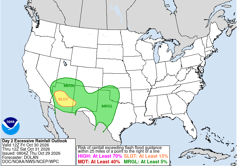
The Weather Prediction Center placed parts of central and southern Arizona in a slight risk of excessive rainfall, level 2 of 4, for Friday. The center said the amount of moisture in the atmosphere over the southern half of the state would rise to 2 to 3 standard deviations above normal. High-resolution forecast models showed a 30% to 60% chance that more than 2 inches of rain would fall within six hours in some areas, the center said.
“Given the sensitive terrain in the area and relatively moist soils across central and southern Arizona, this setup will likely produce scattered instances of flash flooding,” the center said.
The Phoenix office said showers and storms could develop around the metro area as early as 4 a.m. Friday and become more widespread by early afternoon. A few could turn severe, and storms could train, or repeatedly move over the same areas, forecasters said.
Round Two: an Atmospheric River
After a brief lull Saturday, forecasters expect a stronger system to arrive Saturday night. The Phoenix office described it as “one of our stronger ARs that can affect the Desert Southwest,” referring to an atmospheric river, a long plume of moisture that can deliver heavy rain.
“This weather event is shaping up to be a classic El Nino season AR event which would normally occur from late December through February,” the office said.
The weather service said moisture levels could reach record or near-record values for this time of year, at 300% to 350% of normal. Rain rates are expected to be modest, but forecasters said the long duration of the event would make up for it. Rainfall totals Sunday are forecast to average 1 to 1.5 inches in Phoenix and 2 to 3 inches over higher terrain. The office said the National Blend of Models showed a 25% chance of more than 2 inches in Phoenix and as much as 3 to 4 inches in the high terrain.
“Even if the average forecast rainfall totals come to fruition on Sunday, the bulk of the rain will runoff as it will be falling on already saturated soils,” the Phoenix office said. Forecasters said many area washes could fill or overflow and that larger creeks and rivers could flood Sunday into Monday as water works through the basins.
The Flagstaff office forecast 1 to 3 inches of precipitation from early Sunday through early Monday, with locally higher amounts in the southern part of its area. A cold front late Sunday could also bring severe weather and lower snow levels.
“This is a somewhat crazy situation and although there is still some timing/phasing issues Sunday, confidence is growing for yet another major precipitation event,” the Flagstaff office said. “Let us get through Friday first.”
The Weather Prediction Center’s outlook for Saturday morning through Sunday morning again shows a slight risk of excessive rainfall over central Arizona.
Jonathan Erdman, a senior meteorologist at weather.com, said the areas of greatest concern include the north and east sides of the Phoenix metro area. He said ground scorched by recent wildfires is particularly susceptible to fast-moving debris flows and that hikers with weekend plans in Arizona parks should consider canceling.
Last Week’s Flooding
The new rain follows days of severe storms during the week of Oct. 19 that flooded communities across northern and eastern Arizona.
The Hopi Tribe declared a state of emergency Oct. 22 after flash flooding damaged property across the reservation, KNAU reported. The Moenkopi Wash gauge reached 33.92 feet on Oct. 22, nearly 4.9 feet above major flood stage, the station reported, citing U.S. Geological Survey and weather service data. At least eight families were displaced in Moenkopi near Tuba City, AZFamily reported.
On the White Mountain Apache Reservation, about 50 people were evacuated along Cibecue Creek as storms swelled the creek to bridge level, AZFamily reported. On the Navajo Nation, crews rescued 30 people from flooded homes in Dennehotso, KTAR reported, citing the Navajo Police Department.
In the eastern Arizona mining town of Clifton, floodwaters and rockslides damaged homes, vehicles and infrastructure, AZFamily reported. Greenlee County Sheriff Eric Ellison said Ward Canyon Road was washed out again about two hours after crews reopened it, the Eastern Arizona Courier reported.
Staying Safe
The weather service urged residents to monitor forecasts and be ready to act if flash flood warnings are issued, and it warned that low-water crossings may be flooded.
“Turn around, don’t drown when encountering flooded roads. Most flood deaths occur in vehicles,” the weather service said in a flood watch for New Mexico issued Thursday, repeating its standard safety message.
ABC15 in Phoenix forecast 1 to 2 inches of rain in the Valley from Friday through Sunday, with 2 to 3 inches or more in parts of the high country.
High pressure is expected to bring warmer and drier weather from Tuesday onward next week, the Flagstaff office said.
