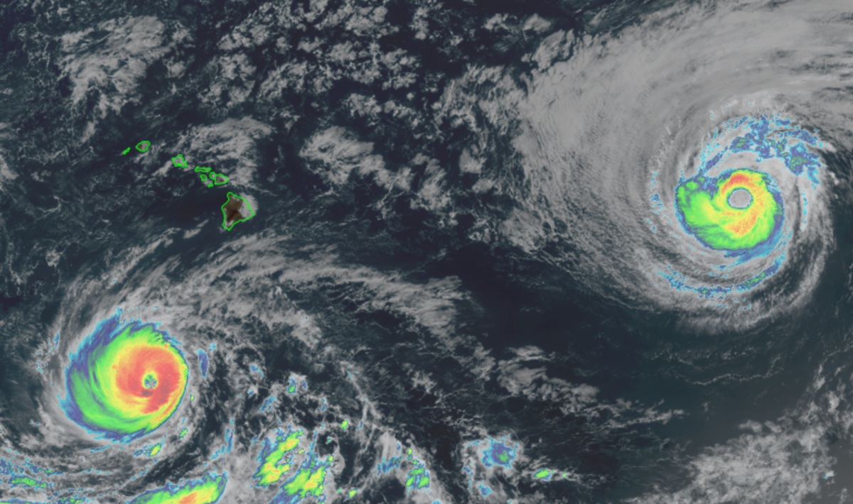
Authorities in Hawaii are encouraging residents and visitors to brace for the possibility of impacts from two monster hurricanes that are approaching the islands. Major Hurricane Lowell is south of Hawaii, packing maximum sustained winds of 140 mph. Major Hurricane Karina is north east of Hawaii, packing maximum sustained winds of 105 mph. Both are large systems that have covered a lot of territory on their march across the Pacific. The big question remains: will either bring direct impacts to Hawaii?
The National Weather Service in Honolulu on the island of Oahu is one entity urging people to be prepared for possible impacts, especially from Lowell. Today, they cautioned people, “Interests in Hawaii should continue to closely monitor the progress of Lowell through the upcoming Labor Day weekend, listen to the advice of officials, and ensure they have their hurricane plan and supply kit in place.”
The County of Kauai is urging people to prepare for possible impacts. They caution, “Please take a few minutes today to check your emergency supplies. Make sure you have at least 14 days of food, water and medications, along with flashlights, a battery-powered radio, and other essentials. It’s also a good idea to have a smaller go-kit ready in case you need to leave home.”
The Hawaii Emergency Management Agency, also known as HI-EMA, is telling people state-wide more of the same: “Forecasters are more confident today that Lowell will make a northward turn towards the Hawaiian Islands on Sunday, but the location of this turn and the subsequent path of the hurricane remain uncertain…Review your family emergency plan and prepare for possible hazards. Hurricane season continues through November, so preparations for a storm that may pass are still useful for any future storms.”
It appears Karina and Lowell will approach Hawaii as if they were dancing tropical cyclones, with atmospheric forces both bringing them closer and steering them apart. Unfortunately for Hawaii, the Aloha State remains in the middle of both storms and the storms could become dangerously close as they dance about in the Pacific.
Even if there isn’t a direct impact, there will be indirect impacts which are already starting to impact the state. A strong pressure gradient between Hurricane Lowell and the subtropical high to the north will bring windy conditions through Friday, before tapering this weekend. Swells and rough surf from both systems will reach Hawaii, with Lowell’s impacts already here on southeastern portions of the state’s shorelines.
The Central Pacific Hurricane Center says Hurricane Lowell will approach the western end of the main Hawaiian Islands late Sunday, bringing possible surf, rain, wind and flooding impacts particularly to the western portion of the state. The extent of impacts will be determined by the eventual track of Lowell.
Lowell now is about 450 miles south-southwest of Hilo on Hawaii (Big Island) and about 605 miles south-southeast of Lihue on Kauai. The official track forecast moves Lowell slowly westward through Friday night with an abrupt northward turn and increase in forward speed on Saturday. The storm could also turn more northeast than north, which has the potential for threatening more of the state.
“While confidence is low whether a direct impact will occur or not, Lowell will likely bring some impacts to the state including storm surge, high surf, wind, and rainfall impacts to portions of Hawaii, particularly as it moves closest to Kauai County Monday and Monday night,” says the National Weather Service. “The extent of these impacts could range from minor to major depending on the eventual path of the storm, and more specifically when the abrupt turn to the north occurs. Regardless, Lowell is forecast to be a category 3 hurricane at its closest proximity. Coastal inundation could also be exacerbated by the peak monthly high tides that are expected to occur Monday.”
While Lowell is forecast to turn north, meteorologists aren’t completely sure when/where this will occur in the next few days. They will be better able to call out specific impacts to islands once that turn occurs. Until then, though, all of these agencies want people in Hawaii prepared for the worst.
