• Skip to primary navigation
  • Skip to main content
  • Skip to primary sidebar

Weatherboy

Weatherboy Weather News, Maps, RADAR, Satellite, and Forecasts.

  • Local
  • Earth Science News
  • RADAR
  • Current Warnings
  • Satellite
  • Current Maps
  • Forecast Maps
  • Video

Blizzard Warnings up as Nor’Easter #3 Arrives

by Weatherboy Team Meteorologist - March 12, 2018

Heavy snow is expected to fall in the northeast from the third nor'easter to impact the region in less than 2 weeks.  Image: Weatherboy
Heavy snow is expected to fall in the northeast from the third nor’easter to impact the region in less than 2 weeks. Image: Weatherboy


Winter Weather Advisories (purple) and Winter Storm Warnings (pink) are up across portions of the Mid Atlantic and Northeast. Blizzard Warnings (red) are up for extreme southeastern New England.  Image: Weatherboy.com
Winter Weather Advisories (purple) and Winter Storm Warnings (pink) are up across portions of the Mid Atlantic and Northeast. Blizzard Warnings (red) are up for extreme southeastern New England. Image: Weatherboy.com

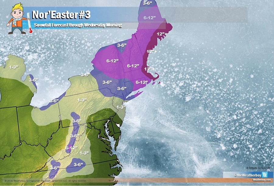
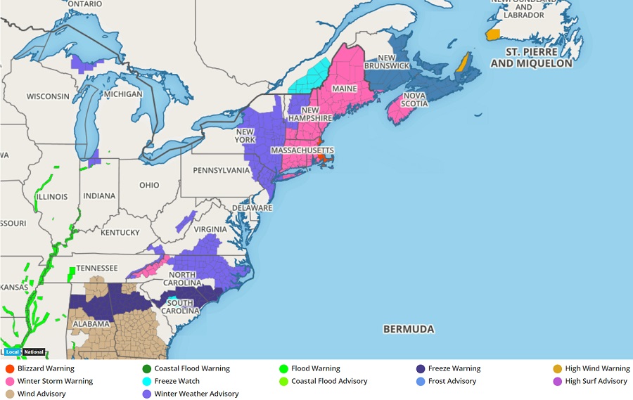
The National Weather Service has issued Blizzard Warnings for portions of southeastern New England ahead of the third major coastal storm to impact the region in less than two weeks. The Nor’Easter will bring wind-whipped heavy snow to the northeast later today into tomorrow, with additional snow shower activity adding to deep accumulations later Wednesday into Thursday. More than a foot of snow is expected over southeastern Maine, coastal New Hampshire, and eastern Massachusetts including Boston by Wednesday morning; an additional 8-12″ more may fall from this storm beyond Wednesday morning.

While most people associate a large snow storm with the word “blizzard”, that is meteorologically incorrect. Blizzards are defined by their winds and visibility; it is even possible to have a blizzard without any fresh snow falling. To meet blizzard criteria, bad weather conditions need to persist for more than 3 hours: namely, winds need to be at 35mph or more and visibility due to either fresh falling snow or blowing fallen snow needs to be reduced down to a quarter mile or less. This blizzard criteria is expected over the southeasternmost portions of New England.


The heavy snow and strongest winds should push into the northeast tonight into tomorrow morning and  begin to wind down from southwest to northeast late Wednesday as low pressure pulls north and east of New England. But with snow showers and gusty northwest winds lingering into Thursday, visibility may drop again from time to time in blowing snow.


Primary Sidebar

Sponsored Ad

Search

Latest News

  • Tropical Storm Watches Issued for East Coast as Tropical Depression Forms
  • System to Impact Southeast U.S. This Weekend Says National Hurricane Center
  • Hurricane Center Says East Coast System Likely to Develop
  • National Hurricane Center Increases Odds of Cyclone Development Near Florida
  • Severe Weather Outbreak Likely in Mid Atlantic
  • July to Start with Severe Weather Event in New Jersey, Pennsylvania, Delaware, & Maryland
  • Tropical Storm Barry Forms; Additional Storm Possible Near Florida
  • Severe Weather Threat & Tornado Risk Returns to Northeast Today
About | Careers | Contact | Contests
Terms | Privacy | Ad Choices
Weatherboy is a (R) Registered Trademark of isarithm LLC, All Rights Reserved.
All content herein is Copyright by Isarithm LLC 1997-2022