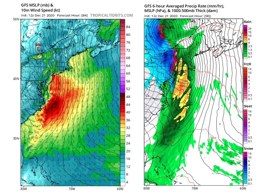
A storm system moving across the eastern portions of North America will produce heavy precipitation and strong, potentially damaging winds on Christmas Eve and Christmas Day. There’s even the threat of some severe storms as the system moves through. And while many people dream of a “white Christmas”, this event will produce more rain than snow in the northeast.
For now, the weather is mainly quiet in the East as high pressure builds across the Mid Atlantic region later tonight into tomorrow. On Wednesday afternoon, the high will shift off-shore, setting the stage for an arriving frontal passage from the west.
On Thursday and Friday, a strong cold front associated with an area of low pressure in Canada will sweep across the northeast. Computer forecast guidance is still not aligned on the timing of this frontal passage. The American GFS model continues to be the fastest of all available guidance, bringing the cold front Thursday evening, while the European ECMWF, Canadian CMC, and other guidance have sped up some bringing the cold front through the area later in the night although not as quick as the GFS suggests. While the time isn’t etched in stone yet, it is more likely than not that frontal passage will occur late Christmas Eve.
Ahead of the front, milder south winds will race north. Some winds could be especially strong; as rain or thunderstorms mix air down from above the surface, there could even be damaging wind gusts in excess of 50 mph in parts of the Mid Atlantic. Sustained winds of 20-30 mph will be likely, especially at the immediate coast. Some winds could dislodge outdoor holiday decorations; isolated power outages are possible too. With milder air surging north ahead of the front on these strong winds, plain rain will fall all the way north to the U.S. / Canada border.
Some of that rain will be heavy at times; some embedded thunderstorms could also drop very heavy amounts of rain over a short period of time. With 1-2″ of rain possible over a relatively short period, combined with snow pack that exists in portions of the northeast, there could be flooding concerns. No flood advisories have been posted yet but that could change as the storm system approaches.
Temperatures for most of the event are expected to remain above freezing, keeping the precipitation rain for most of the event. However, as the precipitation is coming to an end behind the front, temperatures will be falling, and any precipitation on the back side could change over to snow, especially if the front passes through early enough and snow showers can develop in the west-northwest flow behind the front. While little to no accumulation is expected across the Mid Atlantic, a few inches of snow could accumulate, especially over the higher terrain of northern New England.
By Christmas Day, the front will be moving offshore and a northwest flow will developing behind as the low pressure system drifts across eastern Canada and high pressure builds across the deep south. With northwest winds building in behind the frontal passage, lake effect snow is possible over northwestern Pennsylvania and western upstate New York. Some very isolated snow showers from these lake effect snows could travel down-wind into portions of the Mid Atlantic. While they may result in some festive snowflakes on Christmas Day, no widespread accumulations of any kind are expected beyond the typical lake effect snow areas closer to the Great Lakes.
Fair weather will build in later Christmas Day as winds relax, setting up a fair and dry start to the weekend for many in the eastern U.S..