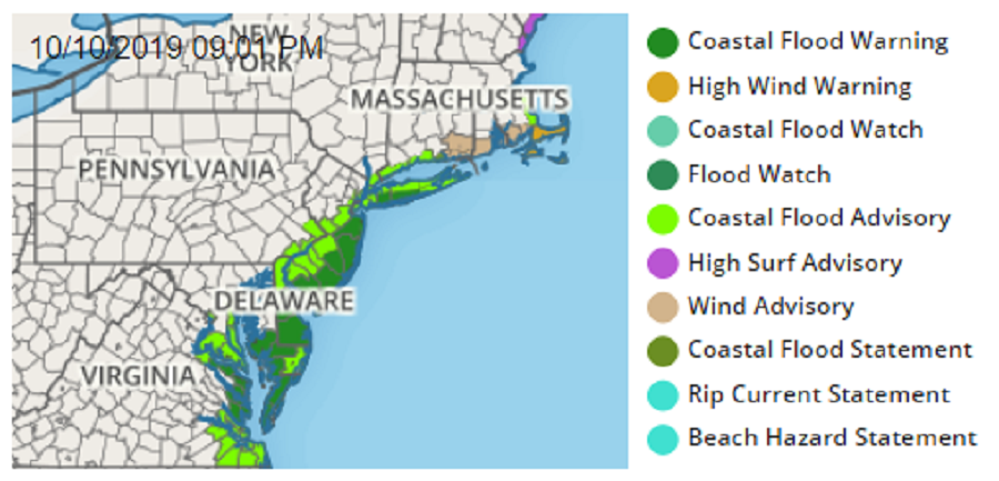
A long duration coastal flood event is expected to continue through Friday, and in some cases Saturday, for portions of the Mid Atlantic and southeast New England coast. Coastal Flood Warnings are up now where flooding is happening right now.
Moderate to major coastal flooding is possible with water from the ocean and back bays inundating land in low-lying areas near shorelines and tidal waterways occuring or imminent. In places where flooding hasn’t started yet, the National Weather Service has issued a Coastal Flood Advisory which means that minor tidal flooding is expected. Minor tidal flooding often results in some road closures. Usually, the most vulnerable roadways will flood.
The National Weather Service warns people in the coastal flood threat area to not leave vehicles at a location that is prone to tidal flooding. They also warn everyone not to drive their vehicle through flood waters; the water may be deeper than one would think, and the water could be hiding dangers like washed-out roads or broken pipes below the surface.
The coastal flooding is being created by a slow moving off-shore storm nearly anchored off the Mid Atlantic coast. While the storm will be too far away from the coast to produce very heavy rain on land, it’ll be close enough to steer winds and waves towards the coast through multiple tide cycles, creating flood conditions from Virginia to Massachusetts.
Moderate rain will be confined to the easternmost portions of Massachusetts where an additional 2-4″ of rain could fall by Saturday morning. New York City will only see light rain totals of a quarter inch or less; Philadelphia may not see any measurable rain from the storm through Saturday.
An approaching cold front will help push the storm away, bringing clearer skies and fair weather for Sunday across much of the northeast. Winds will diminish allowing the surf to relax. But before it does, expect rip currents and beach erosion in additional to coastal flooding threats through Saturday afternoon.
