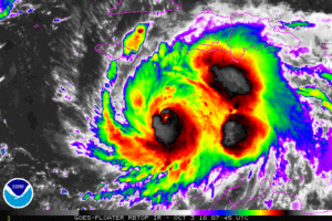
Major Hurricane Matthew is about to make a catastrophe across portions of Haiti, with Jamaica, Cuba, the Bahamas, and perhaps the US East Coast in its future sights.
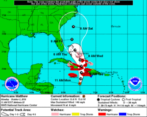
Hurricane Matthew is moving toward the north near 6 mph and this general motion is forecast to continue through Wednesday with an increase in forward speed expected tonight. On the forecast track, the center of Hurricane Matthew will approach southwestern Haiti tonight, move near eastern Cuba late Tuesday, and move near or over portions of the southeastern and central Bahamas Tuesday night and Wednesday.
Data from an Air Force Reserve Hurricane Hunter aircraft indicate that maximum sustained winds are near 140 mph with higher gusts. Matthew is a dangerous category 4 hurricane on the Saffir-Simpson Hurricane Wind Scale. Some fluctuations in intensity are possible during the next couple of days, but Matthew is expected to remain a powerful hurricane through Wednesday.
Hurricane-force winds extend outward up to 35 miles from the center and tropical-storm-force winds extend outward up to 185 miles. The latest minimum central pressure based on data from the aircraft is 941 mb (27.79 inches).
WIND
Hurricane conditions are expected to first reach Haiti tonight, eastern Cuba Tuesday, and the southeastern Bahamas late Tuesday. Tropical storm conditions are expected to first reach Haiti this afternoon, eastern Cuba tonight, and the southeastern Bahamas early Tuesday, making outside preparations difficult or dangerous. Preparations to protect life and property should be rushed to completion.
Tropical storm conditions are expected in Jamaica and along the southern coast of the Dominican Republic within the warning area beginning today.
Hurricane conditions are possible in the hurricane watch areas by Tuesday night with tropical storm conditions possible on Tuesday. Tropical storm conditions are also possible in the tropical storm watch area in the Dominican Republic by late today.

RAINFALL
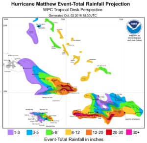
Matthew is expected to produce total rainfall amounts in the following areas:
- Southern Haiti and southwestern Dominican Republic: 15-25″ with isolated amounts up to 40″
- Eastern Cuba and northwestern Haiti: 8-12″ with isolated amounts up to 20″
- Eastern Jamaica: 5-10″, with isolated amounts of 15-20″
- Southeastern Bahamas: 8-12″ with isolated amounts up to 15″
- Turks and Caicos Islands: 2-5″ with isolated amounts up to 8″
- Northeastern Haiti and the Dominican Republic: 1-3″ with isolated amounts up to 5″
- Western Jamaica: 1-2″ of rain
Life-threatening flash floods and mudslides are likely from this rainfall in southern and northwestern Haiti, the southwestern Dominican Republic, and eastern Cuba. 2″ or more of rain will create life-threatening conditions in these areas; amounts 10x or greater than that will be completely catastrophic.
STORM SURGE
The combination of a dangerous storm surge and large
and destructive waves could raise water levels by as much as the
following amounts above normal tide levels…
- Southern Coast of Cuba east of Cabo Cruz: 7-11 feet
- South Coast of Haiti: 7-10 feet
- Northern Coast of Cuba east of Camaguey: 4-6 feet
- Jamaica: 2 to 4 feet
- Gulf of Gonave in Haiti: 3 to 5 feet
- Southern coast of the Dominican Republic: 1 to 3 feet
- Central and southeastern Bahamas: 10 to 15 feet
Surge-related flooding depends on the relative timing of the surge and the tidal cycle, and can vary greatly over short distances. Large waves generated by Matthew will cause water rises to occur well in advance of and well away from the track of the center.
SURF
Swells generated by Matthew will continue to affect portions of the coasts of Hispaniola, Jamaica, Aruba, Colombia, eastern Cuba, and the Caribbean coastline of Central America during the next few days. Swells from Matthew will begin affecting portions of the Bahamas on Tuesday. These swells are likely to cause life-threatening surf and rip current conditions. Wave heights this morning were reported in the 25-35 foot range.
FUTURE TRACK & HURRICANE ACTION PLAN
Significant uncertainty remains with regards to the future track of Hurricane Matthew. The storm may hug the US East Coast or make landfall anywhere from Florida to Maine; because of that risk, all East Coast residents should make sure their Hurricane Action Plans are in order.
Residents of -any- state that touches the Atlantic Ocean should have a Hurricane Action Plan. In general, you should completely understand where you live, how to identify it on a map, and understand the risks and threats a tropical cyclone brings to your area. If you live on the coastline or offshore islands, plan to leave. If you live near a river or in a flood plain, plan to leave. If you live on high ground, away from coastal beaches, consider staying. In any case, the ultimate decision to stay or leave will be yours. Study the following and carefully consider the factors involved especially the items pertaining to storm surge. As part of your Hurricane Action plan, learn the storm surge history and elevation of your area; learn safe routes inland; learn location of official shelters. If you have a boat, determine where to move it in an emergency. Well before a storm arrives, trim back dead wood from trees, check for loose rain gutters and down spouts, and check shutters should you have them to protect from storms. If your shutters do not protect windows or you have no shutters for your home, be sure to stock boards to cover glass or at least know the size(s) of boards you’d need should a storm threaten your area.Your Hurricane Action Plan should also inform you on what to do when a Hurricane Watch or Warning is issued for your area.
When a Hurricane Watch is issued for your area, check often for official bulletins from the National Hurricane Center and the National Weather Service. Fuel your car, check mobile home tie-downs, moor small craft or decide to move it to safe shelter, stock up on canned amd bottled provisions, check supplies of special medicines and drugs, check batteries for radio and flashlights, secure lawn furniture and other loose material outdoors, tape, board, or shutter windows to prevent shattering, and wedge sliding glass doors to prevent their lifting from their tracks.
When a Hurricane Warning is issued for your area, stay constantly tuned to National Hurricane Center and National Weather Service bulletins. If your home is sturdy and on high ground away from the coast, stay home and board up garage and porch doors; move valuables to upper floors; bring in pets; fill containers (such as a bathtub) with several days supply of drinking water; turn up refrigerator to maximum cold and don’t open unless necessary. In a Hurricane Warning, use phone only for emergencies; stay indoors on the down-wind side of a house away from windows. Be aware of the eye of the hurricane and where your home is in relation to it. If you’re in a mobile home, leave as quickly and as safely as you can. Leave other areas which may be affected by storm tide or stream flooding. Leave early in daylight if possible. If you’re leaving, make sure water and electricity are shut-off at main strations. Take small valuables and papers but travel light. Make a plan for pets: many storm shelters do not allow pets. If you’re evacuating, drive carefully to the nearest designated shelter using recommended evacuation routes. In evacuations, many roads will be closed while others are turned into 1-way highways away from storm danger areas.
As part of your Hurricane Action Planning now, you should walk yourself and your family through what you’d do if a Hurricane Watch or Warning were to be issued for your area. This practice will help inform you of what you need to do when a storm threat actually arrives. Acting smart and calm will save lives and property and being prepared now well in advance of any threat is the most smart thing you can do.

For the latest on Matthew and the rest of the tropics around the US in the Atlantic and the Pacific, visit our Hurricane & Tropical Weather page here: https://weatherboy.com/hurricanes-tropical-weather/