A dangerous, growing hurricane is headed to the United States; residents from Florida up the U.S. East Coast should be finalizing preparations ahead of Hurricane Michael’s arrival. Impacts to the U.S. will increase in the coming hours and days and time is running out for people to be properly prepared to protect life and property. If they don’t yet have one, people in Florida, Georgia, South Carolina, North Carolina, Virginia, Maryland, Delaware, New Jersey, and New York should make sure they have a Hurricane Action Plan in place immediately; those in watch/warning areas should execute that plan at once.
With landfall likely, various storm-related watches and warnings have been issued. A Hurricane Warning is in effect for the Cuban province of Pinar del Rio while a Tropical Storm Warning is in effect for the Cuban province of the Isle of Youth and the coast of Mexico from Tulum to Cabo Catoche, including Cozumel. A Hurricane Warning means that hurricane conditions are expected somewhere within the warning area. A Tropical Storm Warning means that tropical storm conditions are expected somewhere within the warning. A Storm Surge Watch is in effect for Navarre Florida to Anna Maria Island Florida, including Tampa Bay. A Storm Surge Watch means there is a possibility of life-threatening inundation from rising water moving inland from the coastline during the next 48 hours. A Hurricane Watch is in effect for the U.S. Gulf Coast from the Alabama/Florida border to the Suwannee River in Florida. A Hurricane Watch means that hurricane conditions are possible within the watch area. A watch is typically issued 48 hours before the anticipated first occurrence of tropical-storm-force winds; tropical storm force winds usually make outside preparations difficult or dangerous. A Tropical Storm Watch is in effect for the area extending from the Suwannee River in Florida to Anna Maria Island, Florida, including Tampa Bay. A Tropical Storm Watch is also in effect from the Alabama/Florida border to the Mississippi/Alabama border. A Tropical Storm Watch means that tropical storm conditions are possible within the watch area, generally within 48 hours.
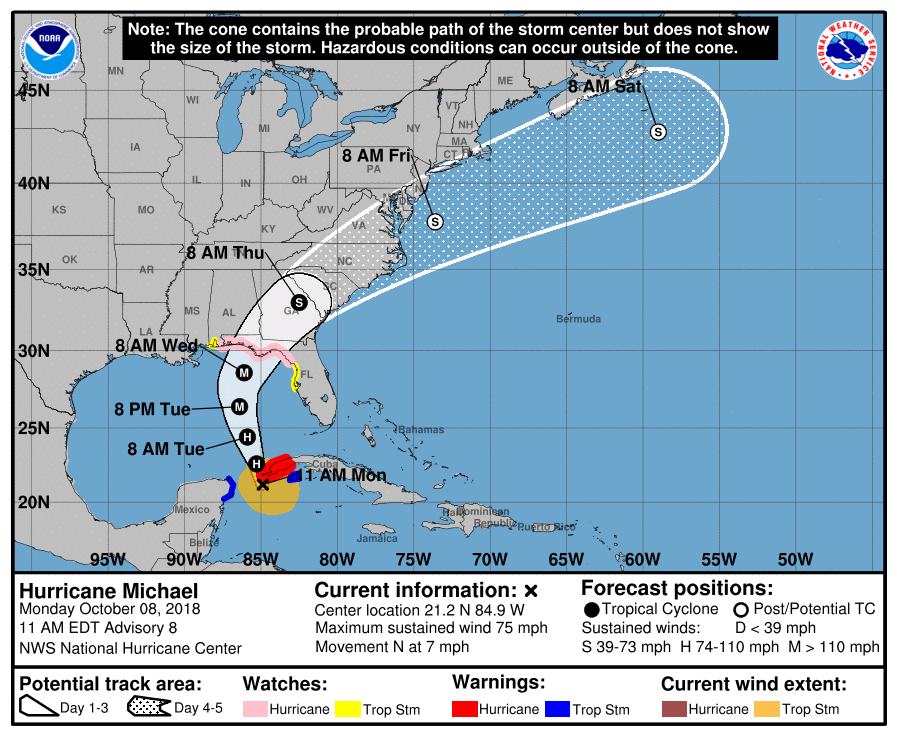
In the latest advisory from the National Hurricane Center, Hurricane Michael was the center of Hurricane Michael was located near latitude 21.2 North, longitude 84.9 West. Michael is moving toward the north near 7 mph. The National Hurricane Center (NHC) says a northward motion at a slightly faster forward speed is expected through Tuesday night, followed by a northeastward motion on Wednesday and Thursday. On the forecast track, the center of Hurricane Michael will move northward near the western tip of Cuba this afternoon and into the southeastern Gulf of Mexico by tonight. Michael will move across the eastern Gulf of Mexico Tuesday and Tuesday night, and is expected to move inland over the Florida Panhandle or Florida Big Bend area on Wednesday, and then move northeastward across the southeastern United States Wednesday night and Thursday.
Damaging winds and flooding rains could be seen as far north as New Jersey and New York from this hurricane as it moves up the Eastern U.S.; clearly, the threats and damage will be greatest in Florida, where the Governor has declared a State of Emergency.
Data from an Air Force Reserve Hurricane Hunter aircraft investigating the storm indicate that maximum sustained winds have increased to near 75 mph with higher gusts, making Hurricane Michael a Category 1 hurricane. Steady to rapid strengthening is forecast during the next day or so, and Michael is forecast to become a Major Hurricane by Tuesday or Tuesday night.
Based on the current analysis of the storm from the NHC, hurricane-force winds extend outward up to 30 miles from the center and tropical-storm-force winds extend outward up to 175 miles. The estimated minimum central pressure based on Air Force Reserve reconnaissance data is 982 mb or 29.00 inches.
Hurricane Michael will bring the threats of significant storm surge flooding, wind damage, and flooding rains to a large area in the eastern United States. Rough surf could also lead to coastal beach erosion and dangerous swimming and boating conditions far away from the storm.
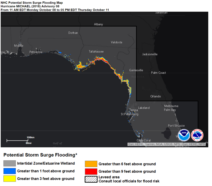
A potentially lethal and destructive storm surge is expected to impact Florida; residents are urged to follow evacuation recommendations there. In the latest storm surge guidance, a destructive 8-12′ storm surge is expected from Indian Pass to Crystal River; a 5-8′ storm surge is expected from the Okaloosa/Walton County Line to Indian Pass; a 4-6′ storm surge is expected from the Crystal River to the Anclote River; a 2-4′ storm surge is expected from the Anclote River to Anna Maria Island including Tampa Bay; a 2-4′ storm surge is expected from Navarre to the Okaloosa/Walton County Line too.
Winds will increase in the U.S. dramatically in the coming days. Hurricane-force wind conditions will spread across the far western part of the Cuban province of Pinar del Rio this afternoon and evening. Tropical storm conditions are expected across the remainder of the warning areas in Cuba and the Yucatan Peninsula later today. Hurricane conditions are possible within the hurricane watch area along the U.S. Gulf Coast by Wednesday, with tropical storm conditions possible by Tuesday night or early Wednesday. Tropical storm conditions are possible within the tropical storm watch area by Tuesday night or early Wednesday.
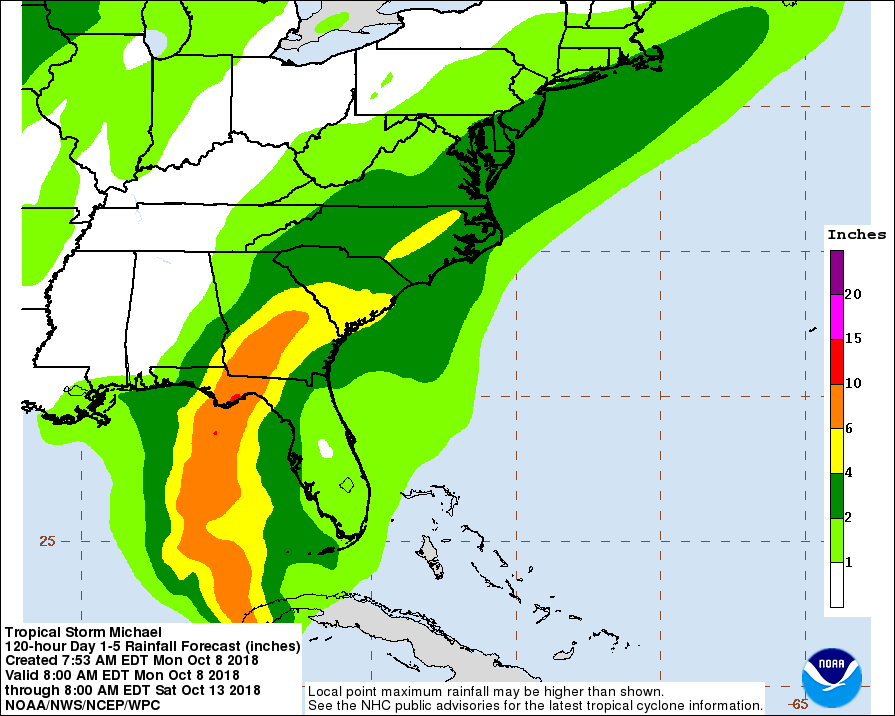
Flooding rains are expected over a large part of the eastern U.S. in the coming days. For now, Michael is expected to produce4-8″ over Western Cuba with isolated maximum amounts of 12 inches. This rainfall could lead to life-threatening flash floods and mudslides there. In the Florida Panhandle and Big Bend into the Carolinas, 4-8″ is expected with isolated maximum amounts of around a foot. This rainfall will lead to life threatening flash floods, including in areas hit hard by Hurricane Florence flooding. In the Florida Peninsula, Florida Keys, portions of the Mid-Atlantic States, and the southern New England coast, 2 to 4 inches with local amounts of 6 inches of rain is forecast. This rainfall could lead to life-threatening flash floods in places like Philadelphia, New York City, Atlantic City, Baltimore, and Richmond.
Swells generated by Michael are affecting the south coast of Cuba and the east coast of the Yucatan Peninsula. Swells are expected to begin affecting the coast of the eastern and northern Gulf of Mexico during the next day or so. These swells are likely to cause life-threatening surf and rip current conditions. Dangerous surf and rip currents are also possible later this week up the U.S. East Coast after the storm makes landfall on the Florida Gulf Coast.
