Image: Peter J. Haeussler, U.S. Geological Survey
A magnitude 3.9 earthquake shook a remote, mountainous stretch of the Alaska Range west of Denali on Monday afternoon, the U.S. Geological Survey said. The handful of people who reported feeling it described weak shaking.
The quake struck at 4:56 p.m. AKST Monday, which was 7:56 p.m. CST and 01:56 UTC on Tuesday, Nov. 17, according to the USGS. The agency located it about 51 kilometers (32 miles) south of Denali National Park, Alaska, a community near the park entrance, at 63.083 degrees north latitude and 151.538 degrees west longitude.
Based on those coordinates, the epicenter was about 17 miles west of the summit of Denali, North America’s highest peak.
The USGS listed the earthquake’s depth at about 1.4 kilometers, or just under a mile, in a solution marked as reviewed. Its magnitude was calculated as a local magnitude, and both the Alaska Earthquake Center and the USGS National Earthquake Information Center contributed solutions for the event.
The Alaska Earthquake Center at the University of Alaska Fairbanks, which monitors seismic activity across the state, named the event “Kantishna M3.9.” Its automated solution placed the earthquake 34 miles southwest of Kantishna, 70 miles northwest of Talkeetna, 140 miles north of Anchorage and 167 miles southwest of Fairbanks. That solution, which listed a depth of about 5 kilometers (3.1 miles), was marked as not yet reviewed by a seismologist; small differences between automated and reviewed locations are common.
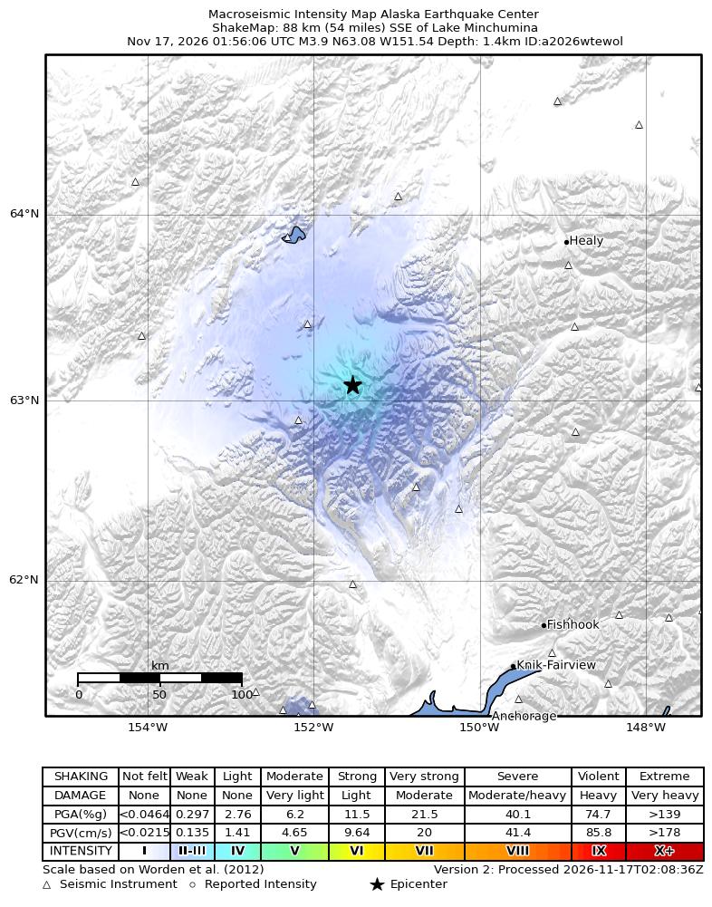
Image: Alaska Earthquake Center / U.S. Geological Survey
Weak Shaking, Sparse Population
The epicenter lies in rugged, glaciated terrain with few residents, which limited how many people could feel the quake.
The USGS “Did You Feel It?” system received two reports by Tuesday morning, both in the weak range, intensity II on the Modified Mercalli Intensity scale. The agency’s community intensity map showed responses from two ZIP codes.
A ShakeMap produced by the Alaska Earthquake Center estimated maximum shaking of about intensity IV, or light, in a small area around the epicenter, with weaker shaking spreading across the surrounding mountains and lowlands. On the ShakeMap scale, light shaking corresponds to no expected damage.
The USGS did not flag the event for tsunami potential. The epicenter lies far inland, more than 100 miles from the nearest coastline on Cook Inlet.
Earthquakes of this size are common in Alaska, the most seismically active state in the nation. The state recorded several other earthquakes of magnitude 3 or greater in the 20 hours before Tuesday morning, including a magnitude 3.9 in the Rat Islands of the western Aleutians, two magnitude 3.6 quakes south of Unalaska and a magnitude 3.6 near Akhiok on Kodiak Island, according to USGS data. None of those had any “Did You Feel It?” reports as of Tuesday morning.
In Hawaii, the USGS recorded small earthquakes of magnitude 2.5 and 2.7 near Pāhala on the Big Island early Tuesday, part of the routine seismicity monitored by the Hawaiian Volcano Observatory. One of them drew a single felt report.
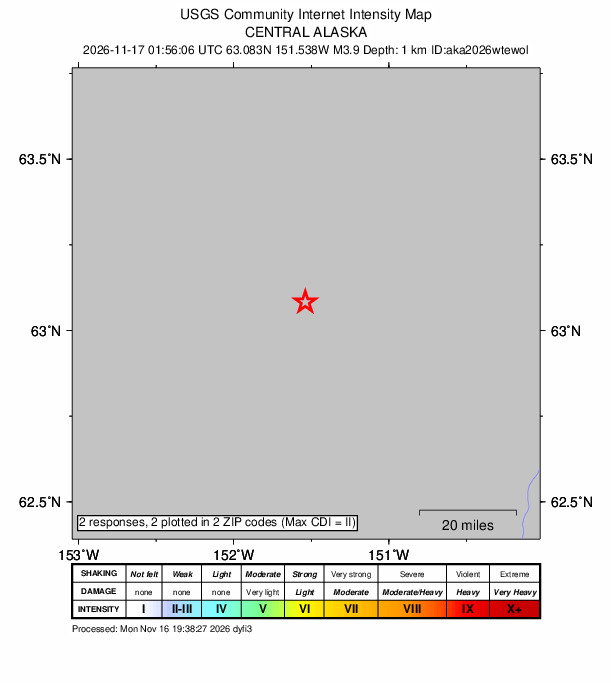
Image: U.S. Geological Survey
Busy Neighborhood
The area around Monday’s earthquake regularly produces small and moderate earthquakes.
A search of the USGS earthquake catalog for the year before Monday’s event found 33 other earthquakes of magnitude 3 or greater within 50 kilometers (31 miles) of the epicenter. The largest was a magnitude 4.5 on Jan. 7, located 64 kilometers southeast of Denali National Park. Others included a magnitude 4.2 on Sept. 28 and a magnitude 4.1 on Jan. 21. The most recent before Monday was a magnitude 3.5 on Nov. 9.
No smaller earthquakes of magnitude 0.5 or greater had been listed in the USGS catalog within 25 kilometers of the epicenter in the hours after the quake as of Tuesday morning.
The Denali Fault and Kantishna Cluster
The Alaska Earthquake Center’s regional summary describes the Denali Fault as “a major intracontinental right-lateral strike-slip fault” that partly accommodates the oblique collision of the Yakutat block with Alaska’s margin. The fault extends from northwestern British Columbia to central and western Alaska.
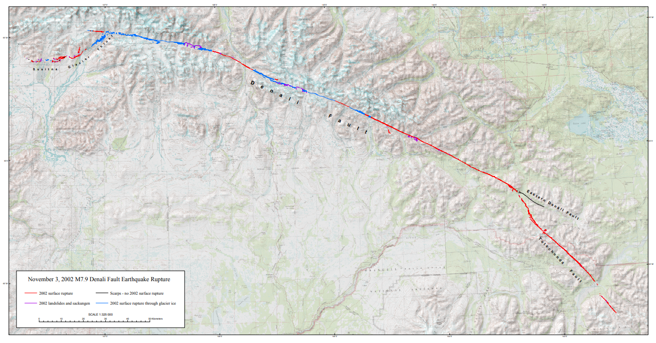
The largest earthquake recorded on the Denali Fault was a magnitude 7.9 on Nov. 3, 2002, the center said. That rupture extended for nearly 270 miles along the central Denali Fault system and was preceded by the magnitude 6.7 Nenana Mountain earthquake on Oct. 23, 2002, which ruptured 25 miles of the fault west of the larger quake.
“It is typical behavior of these major right-lateral faults in the Interior to produce very low background levels of seismicity between large ruptures hundreds of years apart that are followed by multi-year aftershock sequences,” the center said.
The center also noted the Kantishna seismic cluster, located just north of the main fault trace inside Denali National Park. The cluster “produces tens of small, shallow earthquakes every day,” with the largest known quakes there on the order of magnitude 5, which are rare, the center said. Scientists believe the cluster accommodates deformation between the Denali Fault and the Minto Flats Seismic Zone to the north, according to the center.
Neither the USGS nor the Alaska Earthquake Center had attributed Monday’s earthquake to a specific fault as of Tuesday morning.
How it Compares
At magnitude 3.9, Monday’s quake released far less energy than the large earthquakes that have shaped the region. Each whole-number step in magnitude represents about 32 times more energy release, meaning the 2002 Denali Fault earthquake released roughly a million times more energy than Monday’s event.
The quake ranked as the most notable U.S. earthquake or volcanic event in the 20 hours before 6:26 a.m. CST Tuesday because of its size, its location on the mainland near a national park and the felt reports it generated. A magnitude 3.9 in the Rat Islands, recorded at 10:27 a.m. CST Monday, matched it in size but occurred far offshore in the Aleutians and generated no felt reports.
A magnitude 3.0 earthquake about 7 miles east-southeast of Silver Springs, Nevada, at 12:32 a.m. CST Tuesday drew 11 “Did You Feel It?” reports, the most of any U.S. quake in the window, but it was much smaller.
Volcano Observatories Report No Alert Changes
No U.S. volcano changed alert level during the same period, according to USGS volcano notices.
The Hawaiian Volcano Observatory said Monday that the episodic eruption at Kīlauea’s summit remained paused after its 56th lava fountaining episode on Nov. 5, with the summit reinflating. The observatory set a forecast window of Nov. 18 to Nov. 21 for episode 57. Kīlauea remained at an advisory alert level and yellow aviation color code.
The Alaska Volcano Observatory issued a notice Monday morning that strong winds were picking up loose ash from the 1912 Novarupta-Katmai eruption and carrying it southeast. “This phenomenon is not the result of recent volcanic activity,” the observatory said, adding that no eruption was in progress.
Great Sitkin Volcano in the Aleutians remained at a watch alert level and orange aviation color code, unchanged since before the 20-hour window, according to the USGS.
People who felt Monday’s earthquake can submit reports through the USGS “Did You Feel It?” page, which helps scientists map shaking.
