
Image: NOAA/National Weather Service Weather Prediction Center
Days of heavy rain are forecast to pound Florida’s Atlantic coast beginning Tuesday, threatening new flooding in Brevard County and nearby communities where the St. Johns River remains at major flood stage two weeks after a record-breaking downpour.
The National Weather Service in Melbourne issued a flood watch for most of east-central Florida, including Volusia, Seminole, Orange, Osceola, Okeechobee, Brevard, Indian River, St. Lucie and Martin counties, from Tuesday afternoon through Friday evening.
“Repeated rounds of showers and isolated storms are forecast through Friday,” the watch said. Rainfall of 3 to 6 inches is forecast, with localized amounts of 8 to 12 inches. “The greatest potential for these higher amounts will be over the coastal counties,” forecasters said.
The Melbourne office said in its forecast discussion early Tuesday that the risk of excessive rainfall and flooding of roadways and low-lying areas “has increased beginning late today through Friday.”
The Weather Prediction Center, a branch of the weather service, placed east-central Florida in a marginal or slight risk for excessive rainfall each day and a moderate risk, level 3 of 4, on Wednesday for much of the coast, according to the Melbourne office.
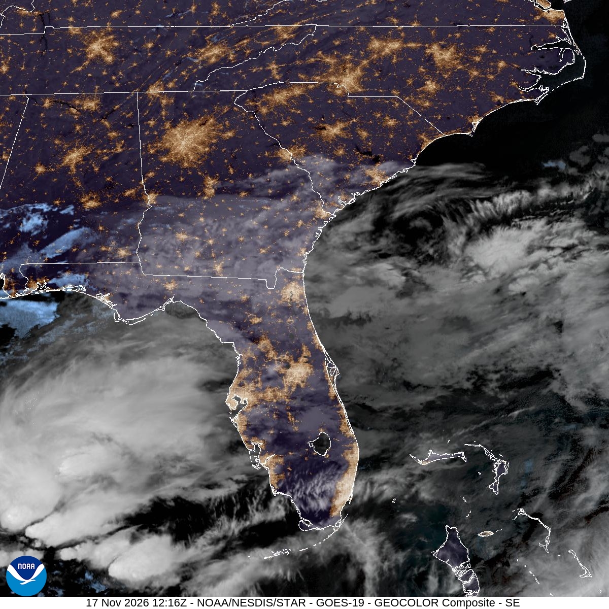
Image: NOAA/NESDIS/STAR
Watches Stretch Along the Coast
Neighboring offices issued their own watches.
The weather service in Jacksonville posted a flood watch for St. Johns and Flagler counties from Tuesday afternoon through Friday evening. “Waves of coastal showers with heavy rainfall at times” are expected along portions of the northeast Florida coast through the end of the week, the watch said, with 4 to 6 inches of rain likely and localized totals of 7 to 12 inches possible.
To the south, the weather service in Miami issued a flood watch for coastal and metro Palm Beach County from Tuesday afternoon through Thursday evening. Several rounds of storms may produce 2 to 4 inches of rain through Friday, with 6 to 8 inches possible and isolated amounts up to 10 inches, the office said. Rainfall rates of 1 to 2 inches per hour are possible in some storms.
Strong high pressure to the north and lower pressure over the Gulf and western Atlantic will keep steady onshore winds over the area, the Melbourne office said. A weakening low over the Gulf and a disturbance aloft will add moisture, with coverage of showers increasing Tuesday night and rain chances of 60% to 80% Wednesday and Thursday.
Forecasters said low-topped showers will develop over the coastal waters and push onshore. “Do not drive through flooded roadways if you encounter flooding!” the Melbourne office said.
A River Already Out of its Banks
The new rain comes as the St. Johns River, which flows north through east-central Florida, is still swollen from earlier storms.
The river near Cocoa was at 17.1 feet at 6:15 a.m. EST Tuesday, above the major flood stage of 17 feet and more than a foot above the 16-foot flood stage, according to National Water Prediction Service data. The weather service said “recent extreme rainfall over the headwaters of the St. Johns River” pushed the river to major flood stage, and its latest forecast shows the river near 17.2 feet by late in the week. The record at that site is 17.5 feet, according to the service’s hydrograph.
At 17.2 feet, the weather service said, “water enters homes along the St Johns River in the Lake Poinsett area west of Cocoa, also low lying homes in the Silver Pines subdivision in Rockledge and the Shakespeare Park area of Cocoa.” The Providence Road area west of Cocoa becomes impassable at that level, cutting off access to homes in the Mullet Lane and Bass Road area, the weather service said.
Farther downstream, the river near Geneva above Lake Harney in Seminole County was at moderate flood stage, at 9 feet Monday evening, a foot above flood stage. At that level, water enters the first story of homes on Whitcomb Drive between Crossover Lane and Lake Harney Road and covers Mullet Lake Park, according to the weather service.
At Astor, where flooding affects Volusia and Lake counties, the river was in minor flood stage at about 2.6 feet, with rises to moderate flood stage forecast later in the week because of the expected heavy rain. Points at DeLand and Sanford are forecast to stay in action stage but could approach minor flooding, the Melbourne office said.
“There is increasing confidence for additional heavy rainfall this afternoon through Friday, which could push all river levels higher,” forecasters wrote.
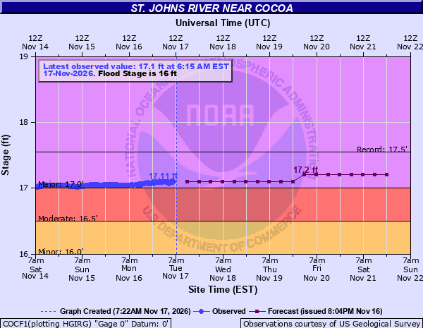
Image: NOAA/National Weather Service
Recovery From Record Rain
Brevard County is still recovering from flooding earlier this month, when more than 20 inches of rain fell in less than 24 hours in some places south of U.S. 192, Central Florida Public Media reported. In Palm Bay, the rain caused Turkey Creek to overflow its banks by more than 8 feet, according to UPI.
County officials said this week’s event is different because it is expected to unfold over several days.
“In this case, we have a rainfall event that’s going to be spread out over a period of days. And people have [an] opportunity right now to get prepared for that,” Brevard Emergency Management Communications Director Don Walker said, according to Central Florida Public Media.
The county planned to provide free sandbags Tuesday from 7 a.m. to 6 p.m., or until dark, at sites in Cocoa, Melbourne and Palm Bay. Titusville residents can fill sandbags at a self-service site at 385 N. Singleton Ave., according to the report.
Because the St. Johns flows north, more rain in Brevard County could eventually raise water levels farther downstream, including in Volusia County, where officials advised residents to review household emergency plans, Central Florida Public Media reported. Florida Today reported that the rain and the moon could combine to lift both the ocean and the river and threaten homes in Brevard County again.
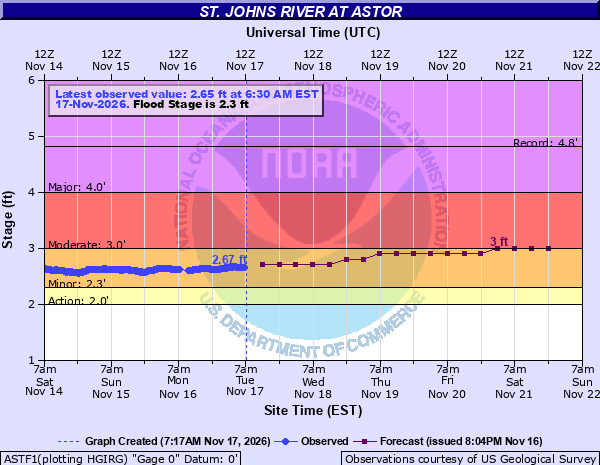
Image: NOAA/National Weather Service
Rough Surf and Beach Erosion
The same pattern is building dangerous conditions at the beaches.
A high surf advisory takes effect at 7 p.m. Tuesday and runs until 1 p.m. Thursday for the coasts of Volusia, Brevard, Indian River, St. Lucie and Martin counties, with large breaking waves of 5 to 10 feet expected in the surf zone. The Melbourne office said “rough, pounding surf will promote moderate to locally major beach erosion” and warned of a high risk of life-threatening rip currents. “Entering the rough and dangerous surf is strongly discouraged!” the office said.
Easterly winds are forecast to increase to 15 to 20 mph each day, with gusts to 25 to 30 mph and occasional gusts to 35 mph at the coast. Gusts of 30 to 45 mph are possible in some showers. Offshore, seas are forecast to build to 8 to 13 feet Wednesday and Thursday.
The Jacksonville office also reported a high risk of rip currents at all area beaches and a high surf advisory for northeast Florida beaches.
What Comes Next
Rain chances remain high Friday as an area of low pressure develops near the northern Bahamas and lifts north parallel to Florida’s east coast Friday and Saturday, the Melbourne office said. Rain chances are forecast to decrease gradually through the weekend and early next week, though hazardous coastal and marine conditions will continue.
The weather service urged residents in flood-prone areas to monitor later forecasts, be alert for possible flood warnings and be ready to act if flooding develops. Motorists should not drive through flooded areas, forecasters said.
