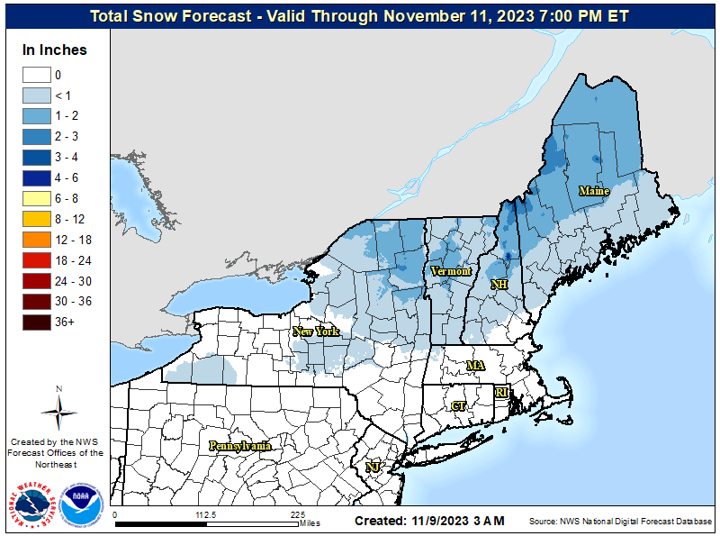
While the calendar says it is only early November, people across portions of the Northeast are experiencing a taste of an early winter season weather event which will bring light snow, sleet, and freezing rain to some in New York, New Hampshire, Vermont, and Maine. Due to the wintry weather, the National Weather Service has issued Winter Weather Advisories across the region.
Troughing over the Central U.S. will support the development of a mid-latitude cyclone over the Northeast today. The attendant cold front extends from the interior Northeast back down to the Southern High Plains. Scattered to isolated showers and thunderstorms are likely to develop around and behind this cold front today, especially over the Southern Plains and Lower Mississippi Valley. But in the colder region to the north and east, rain and snow showers will continue from the Northern Plains through the Great Lakes and into the Northeast. It is possible pockets of freezing rain may even occur over parts of the Northern Appalachians this morning.
The current HRRR high-resolution/short-duration forecast model shows light snow, sleet, & freezing rain making its way through portions of the northeast today.
Watch out for this slick early taste of winter weather!
#NYwx #VTwx #NHwx #MEwx pic.twitter.com/Me2dk5Srxy
— the Weatherboy (@theWeatherboy) November 9, 2023
Due to this wintry weather, the National Weather Service has issued a Winter Weather Advisory for many counties in the northeast at least through this afternoon. In the Winter Weather Advisory zone, mixed precipitation is expected. General total snow accumulations of up to an inch or two are expected while ice accumulations of around one tenth of an inch are possible too.
Beyond the wintry precipitation, winds could also become gusty later this morning into the afternoon. Winds could gusts up to 30 to 35 mph today as the cold front moves through.
The National Weather Service says people in the Winter Weather Advisory zone should plan on slippery road conditions. The hazardous conditions could impact the morning commute. A few power outages are also possible.
Precipitation types will evolve during the day. Snow will mix with sleet and freezing rain then turn to rain. Air and pavement temperatures will rise throughout the day, limiting freezing rain potential in the afternoon. Icy conditions are likely on elevated surfaces like bridges, overpasses, and untreated roadways. The strongest wind gusts will begin as precipitation exits the region. If any ice remains on powerlines, a few localized power outages may occur.
“Slow down and use caution while traveling,” the National Weather Service cautions. “Please allow extra time if travel is necessary.”