According to scientists with USGS’s Hawaiian Volcano Observatory (HVO), earthquake activity has increased from about 60 earthquakes per week to now 600 over the last five years near the town of Pahala. Tucked between Mauna Loa and Kilauea volcanoes, Pahala is a small community with roots as a former sugar plantation. With a population of only about 1,400, residents often feel the earthquakes beneath their feet -often several times per day.
In a 2015 study, USGS scientists located and classified the earthquakes that are occurring in this region into two camps: seismic tremor often linked to deep magma movement and volcano-tectonic earthquakes, indicative of rock breaking under the surface.
The frequent earthquakes that occur here are coming from a region deep underground, roughly 12-25 miles deep. Scientists interpreted the seismic tremor as the migration of magma from the deep Hawaiian hot spot to more shallow depths. Above that magma movement, the volcano-tectonic quakes appear from the tremor region to deep beneath Kilauea Volcano. Based on the linear trend of this earthquake activity, USGS scientists believed the distribution of earthquakes marked a path of magma migration underground the storage below Pahala towards Kilauea’s summit.
A recently released study by seismologists at the California Institute of Technology (CalTech) sheds new light on the processes occurring deep beneath Pahala. These scientists have employed newly developed machine learning to identify a large number of extremely small earthquakes occurring beneath the Pahala region that were previously uncatalogued by HVO. Such microseismicity is too small to be identified using automated methods typically employed to detect earthquakes.
Many of these events are volcanic-tectonic earthquakes located within the zone of deep Pahala seismicity previously identified by USGS scientists. This large number of newly identified volcanic-tectonic events outline what appears to be a region of horizontally layered magma storage deep beneath Pahala, called a sill complex. Adding support to this idea, long period earthquakes, indicative of the movement of fluids such as magma, are seen occurring within these sills. Together, these observations demonstrate that deep seismicity beneath Pahala is consistent with the migration and storage of magma within this sill complex.
Based on the CalTech study, it is believed that the distribution of earthquakes may represent a possible magma pathway from the deep Pahala sill complex into Kilauea’s magma reservoir. HVO cautions that more evidence and studies are required to support or refute such a hypothesis.
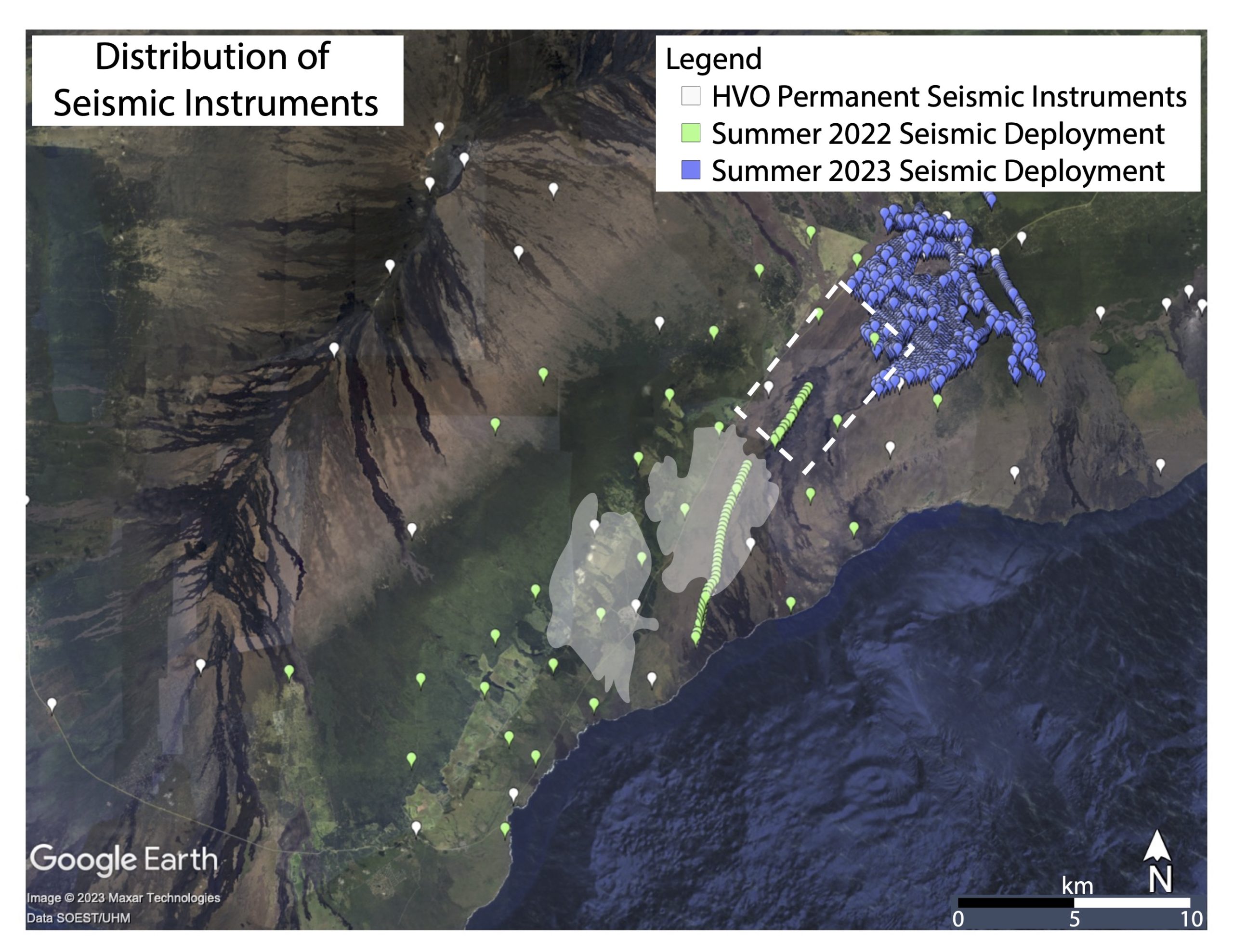
To better understand the seismic and volcanic activity in the area, HVO deployed 86 temporary seismic instruments across Pahala to record earthquakes occurring inside this region over a 3 month program. HVO has also proposed deploying another 1,600 temporary seismic instruments across Kilauea’s summit this summer to record seismic signals there over a 6 week period.
HVO writes in their latest Volcano Watch update that “These dense, temporary deployments will record seismic activity across the Kilauea and Pahala regions more accurately than HVO’s permanent network of instruments. Seismologists at HVO will analyze these seismic data to understand whether magma stored within Pahala’s active sill complex is connected to, and therefore a source of magma for Kilauea volcano.
HVO scientists continue to not only monitor the ongoing earthquakes in Hawaii, but the volcanic activity that is present now.
Right now, the Kilauea Volcano is erupting. Its summit eruption in Halemaʻumaʻu crater within Hawaii Volcanoes National Park continues, with vents erupting in the central eastern portion of the crater floor. Summit tilt has shown several deflation/inflation trends over the past week. Summit earthquake activity remains low and eruptive tremor. A sulfur dioxide emission rate of 3,500 tonnes per day was measured on January 9; these emissions are responsible for smog-like vog throughout the Aloha State.
Mauna Loa, the world’s largest active volcano, is currently not erupting. According to HVO, webcams show no signs of activity on the volcano which wrapped up an eruptive event last month. Mauna Loa. Seismicity remains low. Ground deformation rates and sulfur dioxide (SO2) emission rates are at background levels.
