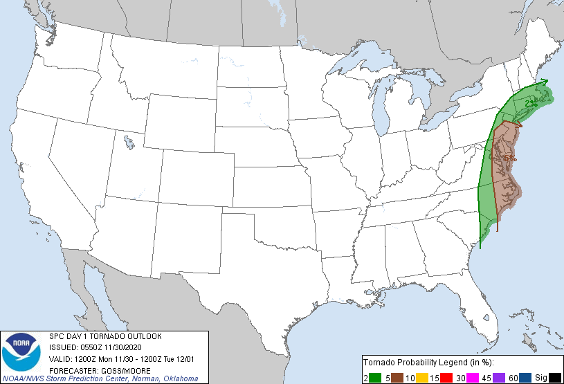
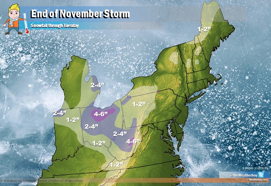
While a potent storm will bring the first widespread snowfall across portions of Ohio and West Virginia, it will also set the stage for isolated tornadoes in portions of the Mid Atlantic, with the greatest threat from New Jersey south to North Carolina.
According to the Storm Prediction Center of the National Weather Service, isolated strong to severe thunderstorms capable of producing damaging winds and a couple of tornadoes will be possible today from parts of Florida into the Carolinas, Mid-Atlantic and southern New England. The remnants of an upper low crossing the southern Appalachians will continue to be absorbed by a sharp northern-stream trough, forecast to be crossing the upper Great Lakes / Mississippi Valley today. As the upper flow field evolves around this storm system, a deepening surface low crossing western North Carolina / Virginia will move quickly northward, reaching central New York where it will then begin to occlude. The trailing cold front associated with the low will move across the Atlantic Coast states through the day, likely clearing the coast from the Mid Atlantic region to Florida through the evening, while a warm sector lingers onshore over southern New England into the overnight hours.
With this type of atmospheric set-up, widespread showers and embedded thunderstorms are forecast to be ongoing over the eastern U.S., with the main band of frontal convection stretching from West Virginia / western Virginia to the Florida Peninsula early today. A limited and local severe potential will be ongoing throughout the day, with a gradual, modest increase in threat expected through the afternoon hours from eastern North Carolina northward into the Mid
Atlantic region.
According to the Storm Prediction Center, a very strong flow through a deep layer suggests the potential for damaging winds, where stronger storms can transport momentum downward. Meanwhile, favorably increasing and veering flow with height through the lower troposphere will also support potential for low-level rotation. As such, a couple of tornadoes are possible where sustained supercell storms can evolve.
At this time, the greatest threat of tornadic cells stretches from north-central New Jersey south through Delaware and eastern Maryland, Virginia, and North Carolina. People in this area should stay alert for any severe thunderstorm or tornado warnings that could be issued during the day.
By mid evening, most thunderstorms will have largely moved off the Mid Atlantic Coast, while some severe risk lingers over southern New England into the overnight hours. Precipitation will gradually end from southwest to northeast on Tuesday in the Northeast.
