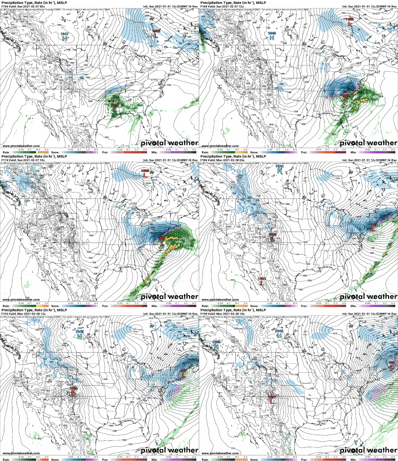
While portions of the Mid Atlantic and New England are getting ready for upwards of 1-2 feet of snow from a very significant snowstorm impacting the region from now through Wednesday, one computer forecast model is suggesting that an even more robust storm could impact the region next weekend. The afternoon European ECMWF forecast run suggests that a potent area of low pressure will form over the southeastern United States next weekend in time for the Superbowl. But is it right?
Before the big game kicks-off in Florida, the ECMWF depicts a strong low pressure system moving through South Carolina. As that happens, moderate snow would be falling over much of Tennessee, Kentucky, West Virginia, the higher mountains of western North Carolina, and much of western Virginia.
By kick-off time for the Superbowl, the ECWMF shows snow expanding in coverage and intensity into Pennsylvania, New Jersey, Delaware, New York, and southern New England. By Monday morning, the center of the storm system is just off the Maine Coast, with falling and blowing snow forecast from Maine to Delaware and from Massachusetts to eastern Ohio.

Unlike the storm impacting the region now, the ECMWF suggests a rapidly intensifying storm system with tightly packed isobars, which are lines of equal pressure. This would translate into very strong winds over a large area and the chance that blizzard criteria could be met. If that happened, this modeled nor’easter would be more impactful than the one in the region tonight.
While many people think a blizzard is simply a big snowstorm, they’re wrong. A blizzard is all about wind and visibility. According to the National Weather Service, three criteria must be reached before a storm is considered a blizzard. First, there needs to be sustained winds of 35 mph or frequent gusts over 35 mph. Second, due to the weather, the visibility must be reduced to 1/4 mile or less. This reduction can happen from falling heavy snow …or it could simply be previously fallen snow blowing about in the wind. You do not need fresh snow to be falling to reach blizzard criteria. Third, to count as a blizzard, the reduction in visibility and the strong winds must last for at least three hours. When all three of these conditions are met, you have more than a snowstorm: you have a full-fledged blizzard!
In addition to strong winds, it also has a colder system forecast than the system impacting / about to impact the region now. As a result, the dominant precipitation type for places like southern New Jersey, eastern Long Island, and extreme southeastern New England would be snow. Snow all around could be heavier than the current storm too, and fall over a shorter period of time.
However, it remains to be seen if the European forecast model is onto something. It is one of many computer models meteorologists use to assist in weather forecasting. While meteorologists have many tools at their disposal to create weather forecasts, two primary global forecast models they do use are the ECMWF from Europe and the GFS from the United States. While the models share a lot of the same initial data, they differ with how they digest that data and compute possible outcomes. One is better than the other in some scenarios, while the opposite is true in others. No model is “right” all the time. Beyond the ECMWF and GFS models, there are numerous other models from other countries, other academic institutions, and private industry that are also considered when making a forecast.
For now, this European run is an outlier: it does not align to its own run from last night nor does it align to the American GFS forecast model output, which suggests a completely different storm-less outlook. Nevertheless, it is worthy of keeping an eye on –especially because it was able to lock in on the storm impacting the Mid Atlantic now fairly early and relatively accurately.