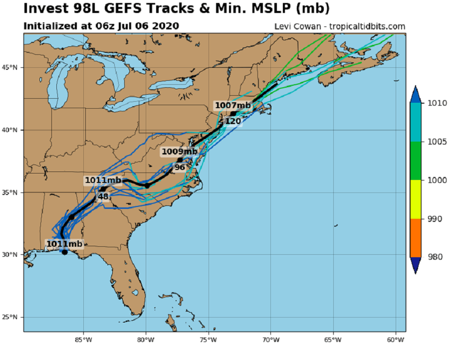
As Tropical Storm Edouard heads deeper into the central Atlantic, eyes are back on the U.S. East Coast for signs of possible tropical cyclone development this week. If the system were to develop into a Tropical Storm, it would be named Fay; if that were to happen, it would be the earliest on record the sixth tropical storm formed in an Atlantic hurricane season.
Currently, the area of concern is in the form of a low pressure system centered inland over southern Georgia. This low pressure formed yesterday over the northeastern Gulf of Mexico and moved inland near Pensacola, Florida. According to the National Hurricane Center, this low is forecast to move northeastward, near the coast of the Carolinas and the mid-Atlantic during the next few days. No additional development is expected while the low remains over land; for a tropical cyclone to take shape, it needs heat energy from the ocean surface to grow. However, should the low move just far enough east over the Gulf Stream in the western Atlantic Ocean just off the Carolina coast, some development will be possible. Computer forecast guidance is offering mixed solutions as to whether or not that’ll happen for now; the National Hurricane Center has upped odds to 40% that a tropical cyclone will form by Friday.
Regardless of development, the low is forecast to bring locally heavy rainfall that could cause flash flooding across portions of the southeast United States over the next several days. By Friday and Saturday, the storm should arrive in the New York City / New Jersey metro area, bringing at the very least heavy showers and gusty winds. If tropical cyclone formation does occur by then, conditions could even be worse.
Whether or not this becomes a tropical cyclone, the National Hurricane Center and the National Weather Service are urging residents in areas vulnerable to tropical cyclone impacts to stock up on essential supplies now well before a storm threatens them anytime in this season. With the ongoing COVID-19 Pandemic, it is important that people prepare to stock-up as far in advance as possible with supply chains broken, stores closed, and common household goods on short supply.
“You’re going to need supplies not just to get through the storm but for the potentially lengthy and unpleasant aftermath,” the National Weather Service advises. “Have enough non-perishable food, water and medicine to last each person in your family a minimum of three days. Electricity and water could be out for at least that long. You’ll need extra cash, a battery-powered radio and flashlights. Many of us have cell phones, and they all run on batteries. You’re going to need a portable crank or solar powered USB charger.”
FEMA encourages people to develop a list of supplies residents may need should disaster strike in hurricane season. “As you prepare your plan, tailor your plans and supplies to your specific daily living needs and responsibilities. Discuss your needs and responsibilities and how people in the network can assist each other with communication, care of children, business, pets, or specific needs like the operation of durable medical equipment,” says FEMA. They encourage that these factors are considered when developing a plan and thinking of supplies that’ll be needed:
- Different ages of members within your household
- Responsibilities for assisting others
- Locations frequented
- Dietary needs
- Medical needs including prescriptions and equipment
- Disabilities or access and functional needs including devices and equipment
- Languages spoken
- Cultural and religious considerations
- Pets or service animals
- Households with school-aged children
With the pandemic here this hurricane season, the CDC is recommending that people bring with them at least 2 cloth face-coverings for each person and if possible, hand sanitizer, if they need to go to a public shelter. If people are evacuating to other locations, such as a hotel that may be open or to a friend or family member’s home, it’s important to bring the same, especially with existing quarantine restrictions in place.