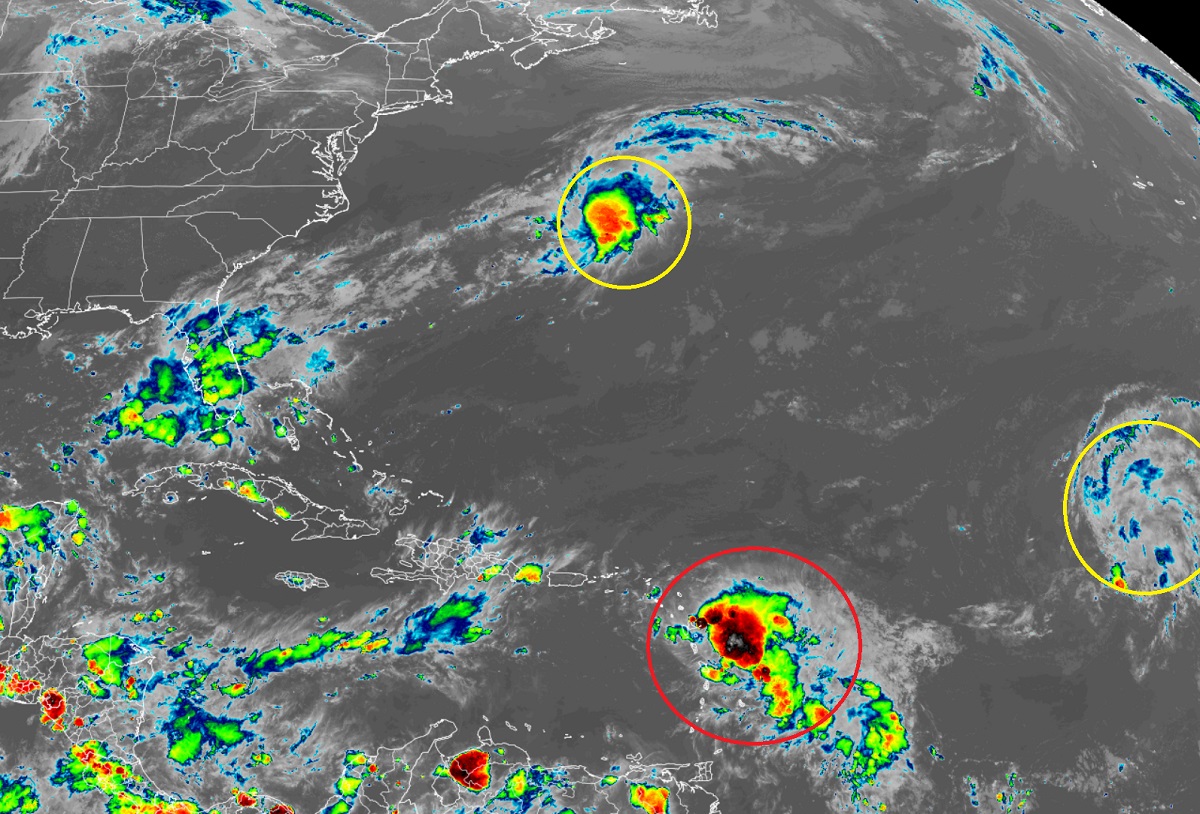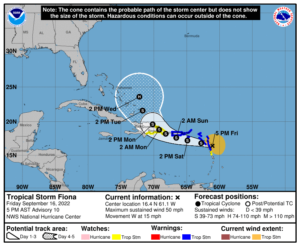
The latest forecast from the National Hurricane Center (NHC) in Miami, Florida calls for Tropical Storm Fiona to strengthen into a hurricane over the next five days. Beyond that, extended computer forecast models suggest the East Coast could see direct or indirect impacts from the hurricane; as such, people along the U.S. coast from Florida to Maine should make sure they have a Hurricane Action Plan in place, just as they should at anytime during the hurricane season.
As of the latest update from the NHC, Fiona, a middle-range tropical storm, was located about 20 miles east-northeast of Guadeloupe and about 260 miles east-southeast of St. Croix in the U.S. Virgin Islands. With maximum sustained winds of 50 mph, Tropical Storm Fiona was moving due west at 15 mph. Fiona’s minimum central pressure is at 1004 mb or 29.65″.
A variety of Tropical Storm Warnings and Watches are now in effect. A Tropical Storm Warning is in effect for Antigua, Barbuda, St. Kitts, Nevis, Montserrat, and Anguilla, Saba and St. Eustatius, St. Maarten, Guadeloupe, St. Barthelemy, and St. Martin, Puerto Rico, including Vieques and Culebra, the U.S. Virgin Islands, and the British Virgin Islands. A Tropical Storm Watch is in effect for Dominica, the south coast of the Dominican Republic from Cabo Engano westward to Barahona, and the north coast of the Dominican Republic from Cabo Engano westward to Cabo Frances Viejo. A Tropical Storm Warning means that tropical storm conditions are expected somewhere within the warning area within 36 hours. A Tropical Storm Watch means that tropical storm conditions are possible within the watch area, generally within 48 hours. The National Hurricane Center says that additional watches or warnings could be required tonight or on Saturday.

According to the NHC, a westward to west-northwestward motion with a decrease in forward speed is expected through early Monday, with a turn toward the northwest forecast for later Monday. On the forecast track, the center of Fiona is expected to move across the Leeward Islands during the next few hours, near or just south of the Virgin Islands and Puerto Rico Saturday into Sunday, and approach the southern or eastern coast of the Dominican Republic Sunday afternoon. Fiona is forecast to move across the Dominican Republic Sunday night and Monday. As it heads west, gradual strengthening is forecast during the next 48 hours or so before the center of Fiona reaches the Dominican Republic on Sunday.
The extended forecast from the NHC brings the storm north and west near the southern Bahamas by Wednesday afternoon, forecasting it to grow into a hurricane by then. Computer forecast models beyond the five day period are conflicted, with some models bringing the storm closer to Florida, the southeast or Mid Atlantic Coast, or simply out to sea, perhaps threatening Bermuda as it does so. At this time, it is just soon to tell where the developing storm will head beyond the National Hurricane Center’s current five day forecast. According to experts at the NHC, no future forecast scenario can be ruled out yet with where this storm may go, including direct impacts to the U.S. coast.
For now, Fiona is creating multiple hazards even as a mid-range tropical storm. Tropical storm conditions are beginning across portions of the Leeward Islands within the warning area and will continue through Saturday. Tropical storm conditions will spread westward to the U.S. and British Virgin Islands Saturday morning, and across Puerto Rico Saturday afternoon and Saturday night. Tropical storm conditions are possible on Dominica this evening or tonight and across the watch area in the Dominican Republic beginning Sunday afternoon.
Fiona is expected to dump very heavy amounts of rain; the Leeward Islands and Northern Windward Islands can expect 3-6″ while 4-6″ is possible in the U.S. and British Virgin Islands. In Puerto Rico, 4-8″ of rain is expected with some isolated heavier pockets of rain up to a foot possible. Such heavy rains could produce flash and urban flooding, along with mudslides in areas of higher terrain, particularly southern and eastern Puerto Rico and the eastern Dominican Republic.

Storm surge threats also exist. The combination of storm surge and the tide will cause normally dry areas near the coast to be flooded by rising waters moving inland from the shoreline. A 1-2 foot storm surge is possible along the southern coast of Puerto Rico. Localized coastal flooding is also possible elsewhere in Puerto Rico and the U.S. Virgin Islands. Storm surge will also raise water levels by as much as 1-3 feet above normal tide levels along the immediate coast in areas of
onshore winds in the Dominican Republic. On top of the surge, swells generated by Fiona are affecting the Leeward and northern Windward Islands, and are beginning to reach the Virgin Islands and Puerto Rico. Swells will then reach the northern coast of Hispaniola, the Turks and Caicos Islands, and the southeastern Bahamas over the weekend. These conditions could cause life-threatening surf and rip current conditions.