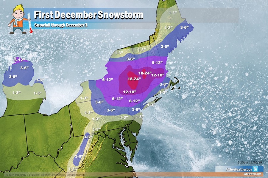
December is going to kick off on a wintry note in the northeast, with the first days of the new month featuring a potent early season snowstorm that’ll dump a foot or more of snow from New Jersey to Maine. Accumulating snow will fall from Philadelphia and portions of the Jersey Shore to central Maine, and from central Pennsylvania and Upstate New York to most points east.
A complex set-up with a Great Lakes storm re-developing into a strong coastal low pressure system is responsible for the wintry weather. Due to how the ingredients are coming together, many people will see a variety of precipitation types which will make pre-treating of roadways tricky.
A light wintry mix should develop on Sunday morning along and west of the I-95 corridor. This could result in some slippery travel conditions. This mixed precipitation should change to plain rain everywhere south of the I-80 corridor. Rain or a wintry mix of snow/sleet/freezing rain will change back to snow on Sunday night along and north of the I-78 corridor. Very heavy snow could fall along and north of the I-80 corridor into central New York state, southern Vermont, and northwestern Massachusetts.
Further south, the rain is expected to change to snow on Monday for portions of southeastern Pennsylvania, central and southern New Jersey, northern Delaware, and extreme northeastern Maryland. While snowflakes will fly, accumulations aren’t expected south of Philadelphia, in and around Wharton State Forest in New Jersey, and in and south of Galloway, New Jersey.
More rain or a mix of wintry precipitation types will also keep snow amounts low or non-existent across far eastern Long Island, Block Island, Nantucket, Martha’s Vineyard, and the Cape Cod area.
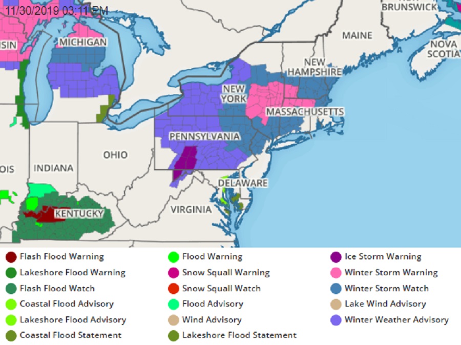
The heaviest snow will fall early Monday across southern interior New England. With high odds for a significant snowstorm, the National Weather Service has begun to issue Winter Storm Warnings for portions of the northeast; Ice Storm Warnings and Winter Weather Advisories are also in effect for portions of Pennsylvania.
Snow totals will be quite significant. 1-2 feet are likely across portions of east-central New York State, including New York’s capital district. 1-2 feet are also possible in the higher terrain of southern Vermont and northwestern Massachusetts near I-91. Heavy snow on Monday could make travel difficult if not impossible for this area.
The I-95 corridor from Philadelphia to Boston will also see accumulating snow. While an inch or two is possible in Philadelphia, Pennsylvania, especially on the north side of the city, 3-6″ are possible in New York City, New Haven, Connecticut, and Providence, Rhode Island. The Boston metre area will see more snow, with 6-12″ storm totals expected there, which significantly more just west of the Boston metro area in interior Massachusetts.
The higher terrain of western West Virginia could also see 3-6″ of snow; more is possible on remote, higher peaks there.
Because of the trajectory of the storm and the location of the coastal redevelopment, far northern New England will be spared from this storm. The northern New York border with Canada, along with the U.SS/Canadian border in Vermont, New Hampshire, and Maine may only see snow flurries with no accumulation.
In western and southwestern Pennsylvania, ice will be a bigger issue than snow, with a substantial glazing of ice possible, mainly Sunday evening, where an Ice Storm Warning is in effect.
Precipitation will end from west to east on Monday and early Tuesday, with fair high pressure building into the region. While most areas will remain dry, cold west winds traveling over the Great Lakes in the wake of this coastal storm will likely kick-up lake effect snow bands in the typical areas on Tuesday and Wednesday. While that could add to snow totals, especially in New York, that won’t be directly tied to the departing coastal storm.
