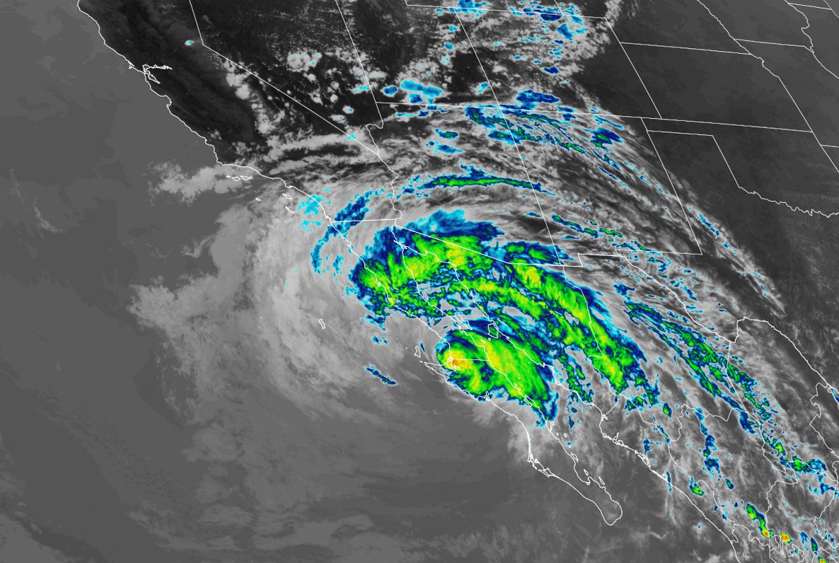
The center of Hurricane Kay made landfall along the west coast of the central Baja California peninsula this afternoon; what’s left of the storm will head towards southern California, increasing the flood threat there.

As of the latest advisory issued by the National Hurricane Center (NHC) in Miami, Florida, Hurricane Kay, a category 1 storm, was located roughly 70 miles southeast of Punta Eugenia, Mexico and roughly 420 miles south-southeast of San Diego, California. The hurricane was moving to the north-northwest up the Baja at 14 mph. The storm’s minimum central pressure is estimated to be 982 mb or 29.00″.
While the Government of Mexico has discontinued the Tropical Storm Warning for the east coast of the Baja California Peninsula from San Evaristo southward, and for the west coast of the Baja California Peninsula south of Puerto Cortes, warnings and watches remain up elsewhere. A Hurricane Warning remains in effect for north of Punta Abreojos to San Jose De Las Palomas while a Hurricane Watch is in effect for Puerto Cortes to Punta Abreojos. A Tropical Storm Warning is also in effect from Punta Abreojos south to Puerto Cortes, the area north of San Evaristo north along the entire coast of the Baja California peninsula and then south to Guaymas in mainland Mexico. A Tropical Storm Warning is also in effect from San Jose De Las Palomas to the U.S. / Mexico border not far from San Diego, California. A Hurricane Warning means that hurricane conditions are expected somewhere within the warning area, in this case in the next few hours. Preparations to protect life and property should be rushed to completion. A Hurricane Watch means that hurricane conditions are possible within the watch area, in this case within the next 12 to 18 hours. A Tropical Storm Warning means that tropical storm conditions are expected somewhere within the warning area.
Right now, Kay is moving toward the north-northwest near 14 mph and the NHC says that this general motion should continue through Friday. A slower northwestward to west-northwestward motion is forecast to begin by late Friday and continue into Saturday. Meanwhile, maximum sustained winds have decreased to near 75 mph with higher gusts and additional weakening is expected during the next couple of days, and Kay is expected to weaken to a tropical storm in the next few hours.
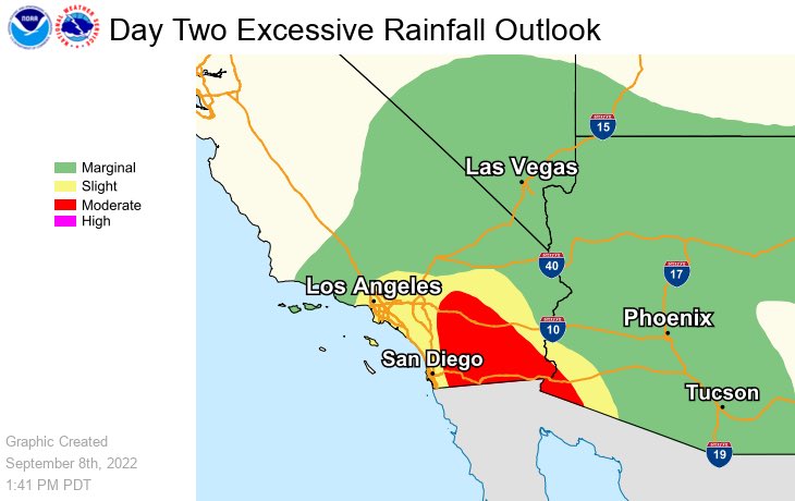
While the storm is weakening and the center is expected to move away from the U.S. and Mexican west coast, moisture from the system will spread north into southern California. There is a moderate threat of excessive rainfall which could lead to significant flood issues east of Los Angeles and San Diego in southern California. The threat of flooding rains from tropical downpours could reach into southern Nevada, southern Utah, and western Arizona too. 2-4″ of rain, with isolated amounts to 8″, are possible across southern California. Southwest Arizona could see 1-2″ of rain, with isolated amounts as high as 3″ possible. These rainfall amounts could lead to flash floods and landslides in mountainous terrain.
Hurricane conditions are expected within the Hurricane Warning for the next few hours, and are possible within the Hurricane Watch area this afternoon and evening. Tropical storm conditions are occurring over the Tropical Storm Warning area and are forecast to spread northward through Friday.
Strong winds not directly associated with Kay’s core wind field are expected across portions of southern California and extreme southwestern Arizona beginning on Friday, prompting high wind warnings to be issued there. Winds may topple branches and wires; winds could also fan wildfires in areas that aren’t getting heavy precipitation.
Swells generated by Kay will continue to affect portions of the coast of southwestern Mexico during the next day or so. Large swells are expected to spread northward along the Baja California peninsula coast, into the Gulf of California, and to southern California during the next couple of days. These swells will likely cause life-threatening surf and rip current conditions and surfers and swimmers are urged to avoid the water until the hazards from Kay pass.
