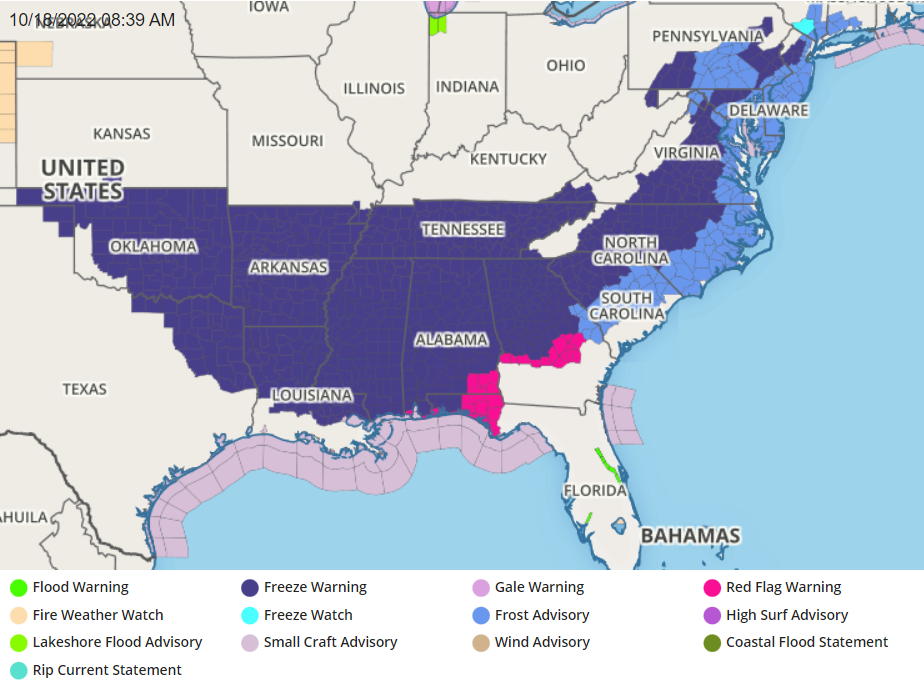
The National Weather Service has issued numerous Frost and Freeze Advisories as cold air is forecast to surge south and east across the United States tonight. Widespread record breaking cold to induce first freeze of the season will pour into the Middle and Lower Mississippi Valley and into the Central and Southern Appalachians and Southeast. This will bring the end to the growing season for many parts of the country, and in some cases much earlier than normal.
The upper low currently stationed over the Great lakes and southern Ontario and southern Quebec will begin lifting north and weakening over the next couple of days. In the meantime, rain and snow showers, wind, and isolated thunderstorms will continue to impact the region. Moderate to heavy snow is also expected over portions of northern Michigan and the Upper Peninsula today, while cold northwesterly flow on the backside of a deep area of surface low pressure generates lake effect snow.

As the low lifts north, surface high pressure will continue to expand across the Great Plains and Mississippi Valley over the coming days. A cold continental airmass will flow into the eastern half of the country today and Wednesday as a result. Widespread high and low temperature records may be tied or broken over the Middle and Lower Mississippi Valley and Southeast today and then over the Central and Southern Appalachians and Florida on Wednesday, with temperature anomalies being between 15-30 degrees below average.
Many places will experience their first freeze of the season over the next couple of nights, which will be particularly impactful to sensitive crops and livestock. Freeze warnings, watches and frost advisories are currently in effect from eastern Colorado to the Appalachians.
Typically, frost can occur when the temperature falls below 36°F, especially in rural areas. It is a localized phenomena and can be quite variable across a small area. While the National Weather Service does not keep track of “frost” in observations per se, they do keep track of when temperatures hit the freezing mark or fall below. Frost becomes more widespread when the temperature falls below 32°F with some freeze possible. A hard freeze is possible when temperatures fall below 28°F.
In a Freeze Warning, frost and freeze conditions will kill crops and other sensitive vegetation.
In a Frost Advisory, Frost could kill sensitive outdoor vegetation if left uncovered.
When a Watch is issued, it is possible warning criteria could be met and a warning could eventually be issued.
The National Weather Service wants people in the impacted areas to take steps now to protect tender plants from the cold. “To prevent freezing and possible bursting of outdoor water pipes they should be wrapped, drained, or allowed to drip slowly. Those that have in-ground sprinkler systems should drain them and cover above-ground pipes to protect them from freezing,” the National Weather Service said in a statement.