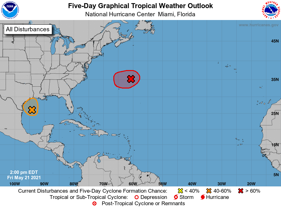
The National Hurricane Center (NHC) is busy tracking two storm threats just a day after NOAA released their seasonal outlook and 10 days before the official start of the 2021 Atlantic Hurricane Season. One system is in the Gulf of Mexico and the other is in the Atlantic Ocean not far from Bermuda.
The system with the greatest threat to the United States is in the Gulf of Mexico. According to the NHC, surface observations and recent satellite wind data indicate that a well-defined low pressure system over the western Gulf of Mexico has winds of 30-35 mph near and east of the center. The associated shower and thunderstorm activity remains limited, but any increase in this activity may result in the formation of a short-lived tropical depression or tropical storm before the system moves inland over the northwestern Gulf coast tonight. Due to that threat, the NHC may issue advisories for this system later today. For now, the NHC pegs the odds of tropical cyclone development to 60% today.
Even if this Gulf system doesn’t develop into a full-fledged tropical cyclone, it could produce heavy rainfall over portions of southeastern Texas and southwestern Louisiana through Saturday. Given the complete saturation of soils with ongoing river flooding along the Texas and Louisiana coastal areas, heavy rain could lead to flash, urban, and additional riverine flooding across this region.
The other system the NHC is tracking is centered about 300 miles northeast of Bermuda. According to the NHC, showers and storms associated with this system have diminished somewhat over the past several hours, and the system has not yet acquired subtropical storm characteristics. However, the low is producing gale-force winds, and according to the NHC, any increase in organization would result in advisories being initiated on the system later today or tonight as it moves westward to west-southwestward to the northeast of Bermuda. For now, the NHC believes there’s a 90% chance that a storm will form here.
Fortunately, even if a storm does form in the Atlantic, the low is forecast to move northeastward into a more hostile environment by Saturday night or Sunday. As such, any existence as a tropical or subtropical storm should be short-lived.
The 2021 Atlantic Hurricane Season officially kicks off on June 1, but storms do sometimes form before the start date of the season. Forecasters believe 2021 will be another busy season in the Atlantic Basin.
