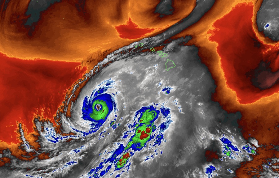
Hurricane and Tropical Storm Warnings are up for portions of Hawaii where Hurricane Lowell is expected to pass through within the next 36-48 hours. While the storm itself is only about 350 miles across, it will help influence the overall weather pattern around Hawaii, bringing wind and rain to areas far from the storm’s eye.
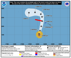
In the latest update from the Central Pacific Hurricane Center (CPHC) and the National Hurricane Center, Major Hurricane Lowell was located about 575 miles south-southwest of Lihue on the island of Kauai and 595 miles southwest of Honolulu on the island of Oahu. The minimum central pressure is down to 943 mb or 27.85″ while maximum sustained winds are up to 125 mph.
For now, a Hurricane Warning is in effect for the Papahanaumokuakea Marine National Monument from Nihoa to French Frigate Shoals while a Tropical Storm Warning is in effect for Kauai County which including the islands of Kauai and Niihau. A Hurricane Warning means that hurricane conditions are expected somewhere within the warning area. A warning is typically issued 36 hours before the anticipated first occurrence of tropical-storm-force winds, conditions that make outside preparations difficult or dangerous. The NHC warns that preparations to protect life and property should be rushed to completion. A Tropical Storm Warning means that tropical storm conditions are expected somewhere within the warning area within 36 hours.
Major Hurricane Lowell is moving toward the north-northwest near 5 mph now. The CPHC and NHC expect that a turn toward the north and north-northeast with an increase in forward speed is expected over the next couple of days, bringing the center of Lowell across portions of the Papahanaumokuakea Marine National Monument, just west of the main Hawaiian Islands, Monday night. Lowell is forecast to turn toward the north-northwest and slow down by Tuesday night after passing the Hawaiian Islands.
Lowell is currently a category 3 hurricane on the Saffir-Simpson Hurricane Wind Scale. The NHC says that some fluctuations in intensity remain possible through this afternoon, followed by gradual weakening beginning tonight. Lowell is expected to remain a major hurricane through Monday.
Hurricane-force winds extend outward up to 50 miles from the center and tropical-storm-force winds extend outward up to 175 miles.
The storm will lash Hawaii with strong winds, flooding rains, and pounding surf.
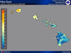
Tropical storm conditions are expected in Kauai County by Monday afternoon or evening. Hurricane conditions are possible in in the Papahanaumokuakea Marine National Monument between Nihoa and French Frigate Shoals Monday night, with tropical storm conditions beginning Monday afternoon. Wind speeds atop and on the windward and leeward sides of hills and mountains are often up to 30 percent stronger than the near-surface winds, and in some elevated locations could be even greater.
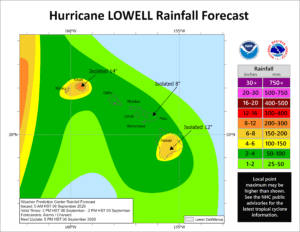
Hurricane Lowell is expected to produce rainfall totals of 6 to 10 inches for Kauai, with maximum totals of 14 inches possible. For the Big Island, 4 to 8 inches of rain is expected with isolated totals of 12 inches possible. For Maui, 2 to 4 inches of rain is expected, with isolated maximum totals of 8 inches possible. Across the remaining islands, rainfall of 2 to 4 inches is possible. This rainfall may produce significant flash flooding and mudslides, especially across Kauai County and portions of the Big Island.
The combination of storm surge and tide will cause normally dry areas near the coast to be flooded by rising waters moving inland from the shoreline. The water could reach 1-3 feet above ground in Kauai and up to 1 foot in Oahu if the peak surge occurs at the time of high tide. The deepest water will occur along the immediate coast near and to the right of the center, where the surge will be accompanied by large and destructive waves. Surge-related flooding depends on the relative timing of the surge and the tidal cycle, and can vary greatly over short distances. Meanwhile, swells from Lowell are likely to cause life-threatening surf and rip current conditions during the next several days across many of the Hawaiian islands.
Hurricane Lowell is also producing a threat of tornadoes and water spouts. The National Weather Service in Honolulu says that the threat of short-lived, fast-moving tornados/waterspouts will be present mainly near Kauai and Niihau as Lowell makes its closest approach to the islands. These would likely be embedded in rainbands.
“The threat for tornadoes is lower near the remaining islands, but not zero,” cautions the National Weather Service. “The threat for tornadoes should decrease quickly early Tuesday morning.”
Lowell is spreading a significant amount of moisture from the south across the entire state. Showers have already been focused over the windward sides of the islands in the trade wind flow. As the winds shift to the southeast tonight, showers will spread to additional areas of the islands. The interaction of the terrain with moisture spreading over the islands could lead to heavy rainfall which could cause some flooding. Because of this threat, a Flood Watch is in effect for all islands starting at noon today, and persisting through Tuesday afternoon.
With Kauai and Niihau being the closest to Lowell, rainfall totals are expected to be highest there, but due to the terrain influence on the Big Island, isolated areas could receive significant rain. Due to an unstable airmass moving over the islands, thunderstorms are possible starting tonight and persisting statewide through tomorrow. These thunderstorms could produce heavy rainfall which could also lead to some flooding.
After Lowell passes through Hawaii, the Aloha State should get a short break from tropical cyclone activity. The Central Pacific Hurricane Center says they expect no other tropical cyclone formation in the basin for at least the next 7 days.
