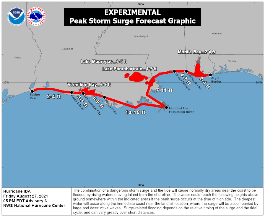
It appears an epic storm surge greater than 10′ is possible when Hurricane Ida slams into the U.S. coastline this weekend as a major hurricane, creating a catastrophic landfall situation for those in its path. Due to the life-threatening danger Ida brings about, Storm Surge Warnings and Hurricane Warnings have now been issued.
A Storm Surge Warning has been issued from east of Rockefeller Wildlife Refuge, Louisiana, to the Mississippi/Alabama border
including Vermilion Bay, Lake Borgne, Lake Pontchartrain, and Lake Maurepas. A Storm Surge Warning means there is a danger of life-threatening inundation, from rising water moving inland from the coastline, during the next 36 hours in the indicated locations. The National Hurricane Center (NHC) warns: “This is a life-threatening situation. Persons located within these areas should take all necessary actions to protect life and property from rising water and the potential for other dangerous conditions. Promptly follow evacuation and other instructions from local officials.”
In the latest update, the National Hurricane Center is forecasting the potential for a peak storm surge of 10-15′ across a large part of the Louisiana coastline; the area near New Orleans could also see a 7-11′ storm surge.
A Hurricane Warning has been issued for the coast of Louisiana from Intracoastal City to the Mouth of the Pearl River, including Lake Pontchartrain, Lake Maurepas, and Metropolitan New Orleans. A Hurricane Warning means that hurricane conditions are expected somewhere within the warning area. A warning is typically issued 36 hours before the anticipated first occurrence of tropical-storm-force winds, conditions that make outside preparations difficult or dangerous. According to the NHC, preparations to protect life and property should be rushed to completion.
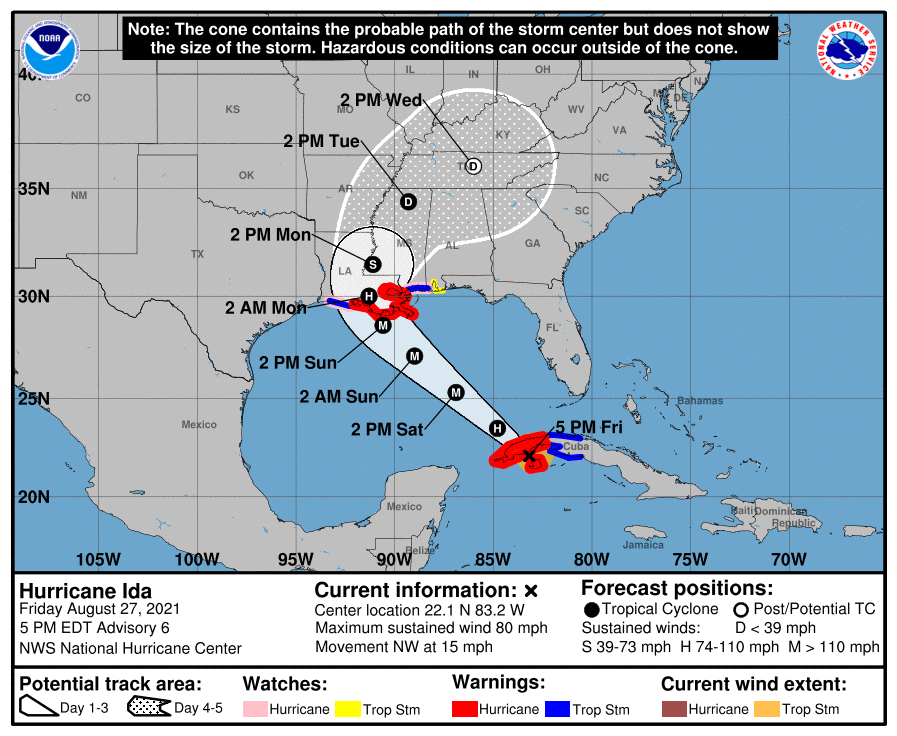
Ida is expected to be an extremely dangerous major hurricane when it reaches the coast of Louisiana. Hurricane-force winds are expected Sunday in portions of the Hurricane Warning area along the Louisiana coast, including metropolitan New Orleans, with potentially catastrophic wind damage possible where the core of Ida moves onshore. The NHC says actions to protect life and property should be rushed to completion in the warning area.
Ida is likely to produce heavy rainfall later Sunday into Monday across the central Gulf Coast from southeast Louisiana to coastal Mississippi and Alabama, resulting in considerable flash, urban, small stream, and riverine flooding impacts. As Ida moves inland, flooding impacts are possible across portions of the Lower Mississippi and Tennessee Valleys.
