• Skip to primary navigation
  • Skip to main content
  • Skip to primary sidebar

Weatherboy

Weatherboy Weather News, Maps, RADAR, Satellite, and Forecasts.

  • Local
  • Earth Science News
  • RADAR
  • Current Warnings
  • Satellite
  • Current Maps
  • Forecast Maps
  • Video

Hurricane Lane, Tropical Storm Ernesto

by Weatherboy Team Meteorologist - August 17, 2018

Like Hurricane Hector, Hurricane Lane is forecast to travel south of Hawaii. But unlike last week's storm, Hawaii could be hit be heavy rain. Image: NHC
Like Hurricane Hector, Hurricane Lane is forecast to travel south of Hawaii. But unlike last week’s storm, Hawaii could be hit be heavy rain. Image: NHC


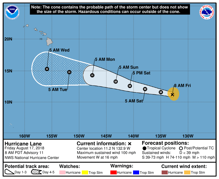
Hurricane Lane continues to chug across the eastern Pacific Ocean and is forecast to enter the Central Pacific Hurricane Basin as a Major Hurricane tomorrow. By the middle of next week, Lane is forecast to pass well south of Hawaii’s Big Island. Even so, heavy rains associated with the hurricane and a moisture plume that surrounds it could soak Hawaii with flood-inducing rains. While it’s too soon to say with certainty what impacts, if any, Lane could have on the Aloha State, the potential exists for 5″ or more of rain, especially on the Big Island, next week. People there should keep an eye on changing weather conditions, have a Hurricane Action Plan, and think-out what they’d do if life threatening floods impacted their region.


Ernesto is moving away from the U.S. while a new system is identified southeast of the Windward Islands. Image: NHC

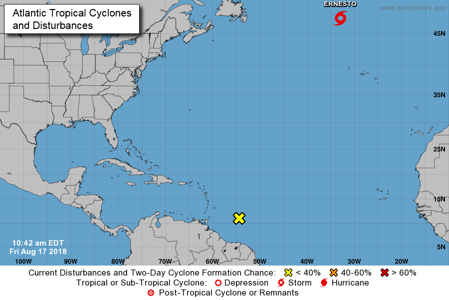
While Lane is getting closer to the U.S. with time, Ernesto is getting farther away. Tropical Storm Ernesto is forecast to transition to an extratropical system tonight as it moves away into the north Atlantic. No direct impacts to land are expected while Ernesto is a tropical system.

A tropical wave located about 400 miles east southeast of the Windward Islands continues to produce disorganized showers and thunderstorms. Environmental conditions are only marginally conducive, and significant development of this system is not anticipated. This disturbance is moving westward at about 15 mph and is forecast to move through the Windward Islands on Saturday, where it could bring locally heavy rainfall there according to the National Hurricane Center.

Elsewhere, there are no tropical cyclone threats to the US.

Primary Sidebar

Sponsored Ad

Search

Latest News

  • Tropical Storm Amanda Forms Well East of Hawaii
  • NASA Verifies Boston Bolide; South Carolina Explosion Remains Mystery
  • 2026 Hurricane Season Arrives Along with a Potential U.S. Threat Developing
  • Spectacular Volcanic Eruption Prompts National Weather Service to Issue Rare Ashfall Advisory
  • USGS Issues VOLCANO WATCH as Lava Reaches Surface; Large Eruption Likely Soon
  • Large Scale Explosion Felt Around Boston and Much of Massachussetts and Rhode Island; Bolide Likely
  • Pair of Unusual Earthquakes Strike South Carolina After Unexplained Explosion and Other Mysterious Quakes
  • Unrelated Explosions in New York, South Carolina, & Florida Light-Up Sky and Set-Off Earthquake Alarms
About | Careers | Contact | Contests
Terms | Privacy | Ad Choices
Weatherboy is a (R) Registered Trademark of isarithm LLC, All Rights Reserved.
All content herein is Copyright by Isarithm LLC 1997-2022

Insert/edit link

Enter the destination URL

Or link to existing content

    No search term specified. Showing recent items. Search or use up and down arrow keys to select an item.